FINDINGS OF FACT AND CONCLUSIONS OF LAW
Statement of the Proceeding and Jurisdiction
1 On March 18, 2016, Glen A. Wallace and Brenda Armentrout (collectively referred to as “Wallace/Armentrout”) submitted a Petition for Administrative Review (“Petition”) with the Natural Resources Commission (“the Commission”) Division of Hearings. The Petition seeks relief under 312 IAC 11-1-3 against Bob Stone, Jr. arising from a dispute involving Stone’s placement of a pier in the waters of Crooked Lake, a public freshwater lake located in Steuben County, Indiana.
2 In the Petition, Wallace/Armentrout failed to identify any potential Respondent by both name and address. Wallace/Armentrout were allowed the opportunity to supplement the Petition to identify the name and address for intended Respondents. On March 26, 2016, Wallace/Armentrout filed a supplement to the Petition and identified the names and addresses for the Respondents, Robert Stone (“Stone”) and Kevin and Cathy Summers (“the Summers”).
3 In the Petition, Wallace/Armentrout maintain that they are the owners of Lot #4 and Lot #5 in Rose Lawn subdivision and that Stone connected a pier to the Summers’ pier that encroached upon the riparian zone of Wallace/Armentrout. In addition, the Petition avers that Stone has no right to install a pier because no such right is identified in his deed.
4 The Petition, along with the supplement filed on March 26, 2016, initiated a proceeding governed by Indiana Code (“IC”) 4-21.5-3, sometimes referred to as the “Administrative Orders and Procedures Act” (“AOPA”) and the administrative rules adopted by the Commission at 312 IAC 3-1 to assist with the implementation of AOPA.
5 Administrative Law Judge (“ALJ”) Dawn Wilson was appointed under IC 14-10-2-2 to conduct this proceeding.
6 On March 30, 2016, the Department of Natural Resources (“Department”) filed its “Joint Appearance of Counsel for Department of Natural Resources for a Limited Purpose and Request for all Filings, Discovery Requests, Notices, Reports, and Orders”. For the reason that the Department is entrusted to hold and control public freshwater lakes for the benefit of the public pursuant to IC 14-26-2-5, the Department’s request was granted on March 31, 2016.
7 Following the issuance of service of notice to Wallace/Armentrout, Stone, Summers and the Department, ALJ Wilson set a Prehearing Conference for May 5, 2016. On April 14, 2016, a request to continue the Prehearing Conference filed by Stone was granted and the Prehearing Conference was reset for June 2, 2016. On June 1, 2016[1], an email request by the Summers to continue the Prehearing Conference was denied. The Prehearing Conference was conducted, as rescheduled, on June 2, 2016, in Columbia City, Indiana. During the Prehearing Conference:
a Wallace/Armentrout asserted that their lots front on Crooked Lake and are subject to three easements, including a 10 foot easement adjacent to their lot, upon which Stone placed a pier.
b Stone asserted that he is an off-lake lot owner with no deeded interest that would authorize him to install a pier. Stone asserted that he potentially possesses the authority to place a pier through a prescriptive easement. Stone asserted that he was told that he would have a right to install a pier lakeward of a 10 foot easement between Lot #5 and Lot #6 when he purchased Lot #2 in 2000.
c The Summers’ failed to appear at the Prehearing Conference and a Notice of Proposed Default was issued. The Summers filed a response and an Order Setting Aside Proposed Default was issued on June 13, 2016.
8 On July 5, 2016 and September 6, 2016, Status Conferences were held, with all parties present telephonically.
[VOLUME 14, PAGE 141]
9 On November 10, 2016, Michael Morrissey filed his appearance as counsel for Wallace/Armentrout.
10 On November 14, 2016 a Final Status Conference was held, with all parties present telephonically.
11 On November 17, 2016, an Administrative Hearing of the facts was conducted as scheduled, in Columbia City, Indiana. Wallace/Armentrout appeared in person and by counsel, Michael Morrissey. Respondent Stone appeared in person, self-represented.[2] Respondents Summers appeared by Kevin Summers, self–represented. The Department, by counsel Matthew Rea, observed.
12 Following the presentation of all evidence, the parties were offered the opportunity to present post hearing briefs on or before December 16, 2016. On December 16, 2016, Wallace/Armentrout, by counsel Michael Morrissey, filed their Proposed Findings of Fact, Conclusions of Law, and Judgment. Neither Stone nor the Summers filed any post hearing brief.[3]
13 The Lake Preservation Act places full power over public freshwater lakes in the State of Indiana. The State, through the Department, is responsible to “hold and control all public freshwater lakes in trust for the use of all the citizens of Indiana for recreational purposes.” IC 14-26-2-5(d), Indiana Dept. of Nat. Res. v. Lake George, 889 N.E.2d 361 (Ind. App. 2008) and Lake of the Woods v Ralston, 748 N.E.2d 396, 401 (Ind. App. 2001).
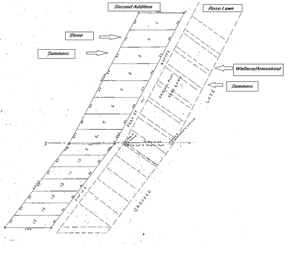
14 The Commission is responsible for controlling activities occurring “over, along, or lakeward of the shoreline or water line of a public freshwater lake”, IC 14-26-2-23, including the placement and maintenance of temporary structures, including piers. The Commission is also charged with resolving “a dispute among persons with competing riparian interests” associated with a public freshwater lake. Id.
15 The Commission has adopted a nonrule policy document under IC 4-22-7-7 to aid in determinations concerning riparian zones within public freshwater lakes. See Public Freshwater Lakes and Navigable Waters, Information Bulletin #56 (Second Amendment), Indiana Register, 20100331-IR-312100175NRA (March 31, 2010) (“Information Bulletin #56”).
16 The Commission is the “ultimate authority” for determinations under the Lake Preservation Act and has adopted rules at 312 IAC 11 to assist with administration of the Lake Preservation Act. IC 4-21.5-1-15 and 312 IAC 3-1-2.
17 The Commission has jurisdiction over the subject matter of this proceeding and over the persons of the parties and this matter is ripe for disposition.
Findings of Fact[4]
18 Crooked Lake is a public freshwater lake in Steuben County, as defined at IC 14-26-2-3 and 312 IAC 11-2-17 and is listed as such in the “Listing of Public Freshwater Lakes”, Information Bulletin #61 (Fifth Amendment), Indiana Register, http://www.in.gov/legislative/iac/20160127-IR-312160050NRA.xml.pdf (January 27, 2016), page 8.
19 In order to assist the reader’s understanding of the ownership of relevant lots and the proximity of each of these lots to Crooked Lake, a portion of Petitioners’ Exhibit 2, the plat for the Second Addition to Rose Lawn, is being reproduced. Text boxes have been added to assist the reader in identifying the two subdivisions and the lots relevant to this decision.
a Generally, the top of the reproduction represents north.
b The unnumbered lots, to the east of the road identified in the plat as Park St., having frontage of Crooked Lake, are in Rose Lawn subdivision. Only Lot #4 through Lot #17 to Rose Lawn appear in the Second Addition plat below.
c The numbered lots, to the west of Park St., are in the Second Addition.
d
20 On April 17, 1903, the plat for Rose Lawn subdivision (“Rose Lawn”) was recorded in Steuben County. Within Rose Lawn, the plat and deeds admitted at the administrative hearing reveal the following:
a The plat identifies 17 sequentially numbered lots with Lot #1[5] at the northernmost end of the subdivision to Lot #17 at the southernmost end of the subdivision. See Exhibit 1.
b In a generally westerly direction and adjacent to Lots #1-11 is Park St.[6] See Exhibit 1.
c Park St. is now known as “Sycamore Beach Rd.” See testimony of Wallace.
d In a generally easterly direction from Lots #4-16[7] is Crooked Lake. See testimony of Wallace and Exhibit 1.
e There are seven 10 foot alleys that connect Sycamore Beach Road to the Crooked Lake shoreline. Some lots are adjacent to alleys, but not all lots. The plat does not include a stated purpose for the alleys. See Exhibit 1.
f Lot #4 is owned by Glen Wallace (“Wallace”) and is bounded to the northwest by Sycamore Beach Rd. for 40 feet, to the northeast by Lot #3[8] for 134 feet, to the southeast by Crooked Lake for 40 feet and to the southwest by an alley. See testimony of Wallace and Exhibit 1.
g The 10 foot wide alley that is adjacent to Lot #4 to the northeast, is also adjacent to Lot #5 to the southwest. The alley connects Sycamore Beach Road and Crooked Lake. See Exhibit 1.
h Lot #5, owned by Wallace/Armentrout, is southeast of Lot #4. Lot #5 is bounded to the northwest for 40 feet by Sycamore Beach Rd., to the northeast by an alley, to the southeast for 40 feet by Crooked Lake and to the southwest by an alley. A deed to Wallace/Armentrout for Lot #5 was recorded on May 8, 2007. See testimony of Wallace, Armentrout and Exhibits 1, 3 and 9.
i The 10 foot wide alley that is adjacent to Lot #5 to the northeast is also adjacent to Lot #6 to the southwest. The alley connects Sycamore Beach Road and Crooked Lake. See Exhibit 1.
j Lot #6, owned by the Summers, is southeast of Lot #5. Lot #6 is bounded to the northwest for 40 feet by Sycamore Beach Rd., to the northeast by an alley, to the southeast for 40 feet by Crooked Lake and to the southwest by an alley. A deed to the Summers for Lot #6 was recorded on August 9, 2016. See Exhibits 1 and 5.
k Two houses appear on Lot #6. One house fronts on the Crooked Lake shoreline. The other house fronts on Sycamore Beach Rd. The topography of Lot #6 includes a steep incline from the shoreline to Sycamore Beach Rd. See Exhibit 9 and 10.
[VOLUME 14, PAGE 142]
21 On November 13, 1913, the plat for the Second Add. To Rose Lawn (“Second Addition”) was recorded in Steuben County. Within the Second Addition, the plat, deeds and surveys admitted at the administrative hearing the following is revealed:
a The recorded survey for the Second Addition does not include any directional indicator. However, the plat identifies the physical relationship of the Second Addition to the “ORIGINAL PLAT OF ROSE LAWN” and includes the outline of Rose Lawn, Lots #4-17.
b The Second Addition plat identifies 15 sequentially numbered lots, with Lot #1 at the northernmost end of the subdivision and Lot #15 at the southernmost end of the subdivision. See testimony of Wallace and Exhibit 2.
c No lot within the Second Addition fronts on Crooked Lake. See testimony of Wallace and Exhibits 1 and 2.
d The northern portion of Lot #2 is owned by Stone. A deed to Stone for his portion of Lot #2 was recorded on November 14, 2000. See Exhibit 5, 6 and 7.
e Photographs from a vantage on the waters of Crooked Lake reveal that Stone’s house on Lot #2 is at the top of a steep hill, west of Lot #5, Lot #6 and Sycamore Beach Rd. See testimony of Wallace and Exhibits 9 and 10.
f The southern portion of Lot #2 and all of Lot #3 are owned by the Summers. See Exhibit 5, 6 and 7.
22 Stone acknowledges that the deed to him from John Frank Heifner and Barbara Nell Heifner does not specifically state that he has any authority to place a pier lakeward of the alley situated between Lot #5 and Lot #6 within Rose Lawn. See testimony of Stone.
23 There are easements identified in Stone’s deed but none that reference the alley between Lot #5 and Lot #6 within Rose Lawn. See testimony of Wallace, Stone and Exhibits 7 and 8.
24 When Stone purchased the northern portion of Lot #2, he believed that the purchase included the opportunity to place a pier. Stone’s belief rests in someone telling him he had the right to place a pier and someone showing him where he could place a pier. In addition, Stone’s belief rests on the statements within an Initial Agreement to Sell Personal Property. See testimony of Stone.
25 Stone identified an “Initial Agreement to Sell Personal Property,” as Exhibit A.
a The word “Initial” is handwritten on the document, with the remainder of the title typed.
b The document states it is a “Purchase and sales agreement made by and between John & Barbara Heifner… (Seller) and Robert R. Stone, Jr (Buyer).”
c The document refers to the sale of a cottage and “Furnishings and property rights to all easements…sold in ‘as is’ condition.”
d Contrary to the assertion of Stone, the document is not notarized. Neither the seller, nor the person who signed the document appeared or otherwise testified at the administrative hearing. The document includes a signature above the line marked “seller” and has the following handwritten signature: “Mark O. Heifner on behalf of John & Barbara Heif[ner]”.
e The admitted document is a copy, not an original. The document is in two pages, with the bottom of page 1 stapled to the top of page 2. Page 1 of the document is shorter than page 2.
f An objection to the admission of Exhibit A was raised by Wallace/Armentrout on the following bases:
i) The document was offered after Stone completed his case in chief and was outside the scope of the Petitioners’ cross examination; and
ii) The nature of the document is hearsay.
g In the interest of justice and in reliance on IC 4-21.5-3-26(a) the document was admitted by the ALJ as Exhibit A.
h Stone relied on the statement within the document that refers to the “sale of property rights to all easements” to support his position that he was granted an easement to the alley through the sale.
See testimony of Stone and Exhibit A.
26 In 1989 or 1990, Kevin McKinsey purchased a lot and began to live at 3030 Sycamore Beach Rd. He is no longer lives at that address but still retains an interest in the lot.
a McKinsey became aware that Stone placed a pier “on the water” when he met Stone in 2000.
b McKinsey maintained an awareness that Stone placed a pier “on the water” until the time when McKinsey moved from his lot, approximately eight years later.
c McKinsey did not specifically identify the location of the Stone pier “on the water.” However, a reasonable conclusion is that the Stone pier was placed from 2000 until 2008 in a manner that provided Stone access to Crooked Lake.
d At some point in time, Stone informed McKinsey that the Stone pier was placed at Stone’s easement.
e When McKinsey lived at the lake, McKinsey installed a pier as an off-lake lot owner through an easement. McKinsey did not reveal if his easement was a deeded easement.
See testimony of McKinsey.
27 At the administrative hearing, Wallace acknowledged that in all years subsequent to 2007, the year when Wallace/Armentrout purchased Lot #5, Stone placed a pier lakeward of the 10 foot alley situated between Lots #5 and #6. See testimony of Wallace.
28 In 2015, Stone placed his pier lakeward of the 10 foot alley and changed the direction of the pier so that it was “four foot over where any pier should be.” At that time, the Summers filed an administrative appeal with the Commission that was later dismissed by the Summers[9]. See testimony of Wallace.
29 In March of 2016, Stone placed a three foot pier, with a one foot “bumper,” lakeward of the 10 foot alley between Lot #5 and Lot #6 within Rose Lawn. Stone shared this pier with the Summers and moored Stone’s eight foot pontoon on the Summers’ side of Stone’s pier. At that time, a span of only approximately 1½ feet separated the Stone pier and Wallace/Armentrout pier. See testimony of Wallace and Exhibit 10.
30 In November of 2016, Stone removed his seasonal pier. At the time of the administrative hearing, Stone was storing his pier and pontoon on the 10 foot alley between Lot #5 and Lot #6 within Rose Lawn. See testimony of Wallace.
31 In 2016, Stone installed his pier in a manner consistent with the Third Principle of Information Bulletin #56 and believes that the Third Principle is the most appropriate application of Information Bulletin #56 to delineate riparian zone boundary lines. See testimony of Stone.
32 In 2007, when Wallace/Armentrout bought their lot they installed the Wallace/Armentrout pier in a manner consistent with the Second Principle of Information Bulletin #56 and believe that the Second Principle is the most appropriate application of Information Bulletin #56 to delineate riparian zone boundary lines. See testimony of Stone.
[VOLUME 14, PAGE 143]
33 Subsequent to 2007, Wallace placed his pier lakeward of a point two feet in from his southern property line. Wallace determined the placement for his pier by:
a Determining a starting point at the survey stake placed at the southern boundary of Lot #4.
b Wallace measured 50 feet from Lot #4’s southern boundary in a generally southern direction along the shoreline to reflect both the 10 foot alley between Lot #4 and Lot #5 and 40 feet of Lot #5’s shoreline.
c Wallace then inset the Lot #5 southern boundary two feet from the survey stake.
d Wallace, being aware of an additional survey stake at the street, visually established a parallel line extending the southern boundary of Lot #5 into the waters of Crooked Lake and placed a pot two feet below the water line, marked with orange paint. Wallace placed this pot without the aid of surveying equipment. See testimony of Wallace.
34 No evidence was presented concerning the Summers’ pier placement.
35 Historically, some piers lakeward of properties within Rose Lawn have been placed from the center of property shorelines to avoid disputes over alley use. Other piers have been placed from the property lines. See testimony of Wallace.
36 No information was presented to show whether the historical placement of piers in the vicinity were extensions of a straight line at a perpendicular to the shore, consistent with the Third Principle, or extensions of onshore property boundaries into the public waters, consistent with the Second Principle of Information Bulletin #56.
37 The surveys within in the recorded plats of Rose Lawn and the Second Addition reveal a shoreline that approximates a generally straight line. See Exhibits 1 and 2.
38 The aerial photograph prepared by Chad Hoover as the “geographical representation of Land Ownership records on file in the Steuben County Auditor’s Office, and records in the Steuben County GIS Database” reveals a shoreline that approximates a generally straight line. See Exhibit 11.
39 The shoreline of Rose Lawn generally approximates a straight line, rather than an irregular shoreline at Lot #5, Lot #6 and the alley situated between those two lots.
40 No survey, expert testimony or other evidence was presented to show the degree of the angle at which the onshore property boundaries meet the shoreline for Lot #5, Lot #6 and the alley situated between those two lots.
41 It is acknowledged that no shoreline is exactly perpendicular to the shore, meeting the onshore properties at exactly 90 degrees at all points of contact. However, it is prudent to establish the meander line of the shoreline and the degree at which the onshore property boundaries meet the shoreline’s meander line. While no evidence was presented to show the specific angles at which the meander line meets the onshore property lines, the plats, the aerial photograph and the surveys from 2007 and 2015 reveal the general nature of the meander line of the shoreline. See Exhibits 1, 2, 4, 6 and 11.
42 Based on the plats for Rose Lawn and the Second Addition, the 2007 survey and the 2005 aerial photograph, the following factual conclusions are determined:
a The onshore property boundary between the Lot #5 and the adjacent alley to the south approach the shore at an acute angle on the Wallace/Armentrout property and an obtuse angle at the adjacent alley property.
b The on shore property boundary between Lot #6 and the adjacent alley to the north approach the shore at an obtuse angle on the Summers’ property and at an acute angle at the adjacent alley property.
43 The angle at which the onshore property boundaries meet the general meander line of the shoreline appears to exceed 10% of 90 degrees. See Exhibits 1, 2, 4 and 11.
Conclusions of Law
Commission Authority
44 Wallace/Armentrout dispute that Stone has any right to install, store or maintain a pier in the waters of Crooked Lake and claim that Stone’s pier placement encroaches into the riparian area of Wallace/Armentrout. See the Wallace/Armentrout Petition for Administrative Review.
45 Stone claims that he has sufficient authority through an easement to place a pier at the shoreline of Crooked Lake, within an area described by the plat for Rose Lawn as an alley. Stone claims a potential prescriptive easement for the shoreline of the alley.
46 The Commission’s responsibility to control activities over, along or lakeward of the shoreline of public freshwater lakes includes the placement of a pier. Piers placed within an Indiana public freshwater lake require, as a general premise, that a person may not place a structure “over, along, or lakeward of the shoreline or waterline of a public freshwater lake”, unless the person obtains a permit from the Department. IC 14-26-2-23.
47 Temporary structures may qualify for placement without a written license from the Department. A temporary structure, including a pier, qualifies for a general license by meeting the following criteria:
(b) In order for a temporary structure to qualify, the structure must satisfy each of the following:
(1) Be easily removable.
(2) Not infringe on the access of an adjacent landowner to the public freshwater lake.
(3) Not unduly restrict navigation.
(4) Not be unusually wide or long relative to similar structures within the vicinity on the same public freshwater lake.
(5) Not extend more than one hundred fifty (150) feet from the shoreline or water line.
(6) If a pier, not extend over water that is continuously more than six (6) feet deep to a distance of one hundred fifty (150) feet from the shoreline or water line.
(7) Not be a marina.
(8) Not be a group pier.
(9) Be placed by a riparian owner or with the written approval of a riparian owner.
312 IAC 11-3-1(b)
48 “A person may seek administrative review of the placement or maintenance of a structure under [312 IAC 11-3-1 or 1.2]…of this rule.” 312 IAC 11-3-2
49 “A riparian owner or the department may initiate a proceeding under IC 4-21.5 and 312 IAC 3-1 to seek resolution by the commission of a dispute among riparian owners, or between a riparian owner and the department, concerning the usage of an area over, along, or within a shoreline or waterline of a public freshwater lake.” 312 IAC 11-1-3(a)
50 Wallace/Armentrout sought administrative review on the following disputed issues within the jurisdiction and authority of the Commission:
a The placement and maintenance of Stone’s pier. 312 IAC 11-3-2
b The resolution of a dispute among competing riparian interests, including the riparian boundary lines for Wallace/Armentrout, the Summers and Stone, if applicable. 312 IAC 11-1-3(a).
[VOLUME 14, PAGE 144]
Stone’s Property Interest by Grant
51 The request for administrative review filed by Wallace/Armentrout includes disputed issues concerning whether Stone is a riparian owner or has riparian rights, including the right to place a pier at the shoreline of Crooked Lake. See the Wallace/Armentrout petition for administrative review.
52 During the administrative hearing, Stone correctly identified that Information Bulletin #56 states:
A riparian owner acquires rights to public waters from a fee title that extends at least to the shore. Riparian rights may be transferred in a deed or other real estate conveyance without special mention, but the person who grants the deed may specifically reserve riparian rights. If the grantor reserves riparian rights, the grantee owns land adjacent to the public waters but is not the riparian owner.
Information Bulletin #56, page 2
53 “Riparian rights do not necessarily constitute an independent estate and are not property rights per se. They are licenses or privileges. They constitute property rights of a qualified or restricted nature. A person must have a property interest in the land appurtenant to the water before the person can acquire rights to use the water.” Plymate v Patton, 13 CADDNAR 28, 33-34 (2012), citing Bass v Salyer, 923 N.E.2d 961, 971 (Ind. App. 2010) and Ctr. Townhouse Corp. v City of Mishawaka, 882 N.E.2d 762, 767-68 (Ind. App. 2008). See also Mueller-Brown v Caracci, 13 CADDNAR 156, 159 (2013).
54 “The term ‘riparian rights’ indicates a bundle of rights that turn on the physical relationship of a body of water to the land abutting it.” Plymate, supra, at 31.
55 "Riparian owner" means the “owner of land, or the owner of an interest in land sufficient to establish the same legal standing as the owner of land, bound by a lake….” 312 IAC 11-2-19
56 Stone is the current owner of a portion of Lot #2 in the Second Addition.
57 No portion of Lot #2 is bounded by Crooked Lake.
58 Stone does not assert that he holds fee simple title to property bordering on Crooked Lake.
59 Stone is not a fee title riparian owner.
60 A determination that Stone is not an owner of property that is adjacent to the shoreline of a public freshwater lake does not settle the question of whether Stone is “entitled to install and use a dock in the proper enjoyment” of an easement. Klotz v Horn, 558 N.E.2d 1096, 1097 (Ind. 1990), citing Farnes v Lane, 161 N.W.2d 297, 301 (Minn. 1968). “The issue is not whether the easement holder attains riparian ownership status, but rather, whether he is entitled to use the riparian rights of the servient tenant who has given him access to the body of water bordering the servient estate.” Emphasis supplied by the court in Klotz, at 1097.
61 The dominant owners of an easement may be entitled to use the riparian rights of the servient tenant in accordance with the conveyance by “the express language of the creating document.” Klotz, supra, at 1098.
62 No easement appears in either the plat for Rose Lawn or the Second Addition that specifically grants authority to the owner of Lot #2 within the Second Addition to exclusively use the 10 foot alley between Lot #5 and Lot #6 of Rose Lawn.
63 No easement appears in any deed presented as evidence in this matter that specifically grants authority to any owner of Lot #2 within the Second Addition, including Stone, to exclusively use the 10 foot alley between Lot #5 and Lot #6 of Rose Lawn.
64 No evidence supports that Stone has been granted an express easement in the alley between Lot #5 and Lot #6 to Rose Lawn that would authorize him, as an owner of Lot #2 to the Second Addition, to exercise riparian rights along the shoreline of Crooked Lake.
65 If the alley between Lot #5 and Lot #6 to Rose Lawn was set aside for public use, Stone, as a member of the public would have a nonexclusive right to use the alley.
66 If Stone, as a member of the public, is authorized to use the property set aside for public use, his authorization is not a property interest in the land adjacent to the water’s edge and is not a riparian right or authority to use the riparian rights of another. In that instance, any exercise of a public use right in the shoreline of the terminus of the 10 foot alley, must not interfere with the equal rights of other members of the public. “An owner in common of an easement may not alter or use the land in such a manner as to render the easement appreciably less convenient and useful for other co-owners.” Parkison v McCue, 831 N.E.2d 118, 132 (Ind. App. 2005), quoting Metcalf v Houk, 644 N.E. 2d 597, 601 (Ind. App. 1994).
67 “If access to a public freshwater lake is through a platted public road, an off-lake lot owner has no greater right to use the public road than any member of the general public. The easement is public and not private. Use of a public road to access the lake is a permitted use under the public easement and a non-exclusive right shared with the public. An off-lake landowner does not typically acquire the rights, even following continuous usage in excess of 20 years, to place a pier at the terminus of a public road on the shoreline of a public freshwater lake.” Lawson v. Halliwill, 13 CADDNAR 146, 152 (2013), citing Bass, at 969.
68 Insufficient evidence was presented by any party to establish the plat creator’s intended use for the alley between Lot #5 and Lot #6. However, any permissive right to public use of the alley would not provide Stone with the authority to extend a pier, to the exclusion of other members of the public.
69 Stone has shown no grant of a property interest that would allow him to place a pier at the shoreline of Crooked Lake.
Stone’s Property Interest by Prescriptive Easement
70 A property right through an easement may be created by grant or acquired by prescription. Brown, et al v Heidersbach, et al, 360 N.E.2d 614, 618 (Ind. App. 1977).
71 Stone asserts that he may have a prescriptive easement sufficient to provide him with a property interest in the shoreline terminus of the 10 foot alley between Lot #5 and Lot #6 to Rose Lawn that is appurtenant to Crooked Lake.
[VOLUME 14, PAGE 145]
72 For a party to acquire property by adverse possession, the party must establish these four elements by clear and convincing proof :
(1) Control–The claimant must exercise a degree of use and control over the parcel that is normal and customary considering the characteristics of the land (reflecting the former elements of “actual,” and in some ways “exclusive,” possession);
(2) Intent–The claimant must demonstrate intent to claim full ownership of the tract superior to the rights of all others, particularly the legal owner (reflecting the former elements of “claim of right,” “exclusive,” “hostile,” and “adverse”);
(3) Notice–The claimant's actions with respect to the land must be sufficient to give actual or constructive notice to the legal owner of the claimant's intent and exclusive control (reflecting the former “visible,” “open,” “notorious,” and in some ways the “hostile,” elements); and,
(4) Duration–the claimant must satisfy each of these elements continuously for the required period of time (reflecting the former “continuous” element).
Bass, supra, at 965, citing Fraley v. Minger, 829 N.E.2d 476, 486 (Ind. 2005).
73 The Indiana Supreme Court applied the same elements necessary to support a claim for adverse possession to a claim for a prescriptive easement. “This reformulation applies as well for establishing prescriptive easements, save for those differences required by the differences between fee interests and easements.” Wilfong v. Cessna Corp., 838 N.E.2d 403, 406 (Ind. 2005). Fraley and Wilfong were applied by the Commission in Havel & Stickelmeyer v Fisher, et al at 11 CADDNAR 110 (2007), at 121.
74 A person claiming a prescriptive easement must meet stringent requirements. “Prescriptive easements are not favored by the law.” Carnahan v Moriah Prop. Owners Ass’n, Inc., 716 N.E.2d 437, 441 (Ind. 1999).
75 On land, physical evidence can help establish adverse use, and “[a]n unexplained use for 20 years is presumed to be adverse and sufficient to establish title by prescriptive easement.” Id, at 442, citing Fleck v Hann, 658 N.E.2d 125,128 (Ind. App. 1995), (citing in turn Reder v Radtke, 177 N.E.2d 669, 672 (Ind. App.1961) (quoting in turn Mitchell v Bain, 42 N.E. 230, 231 (Ind. 1895).
76 There is not a similar presumption for a claim to establish a prescriptive easement for recreational use of a body of water. A special showing must be made that the activities were adverse “because recreational use (especially of a body of water) is of a very different character from use of a path or road for ingress and egress over land. Recreational use (especially of water which leaves no telltale path or road) seems to us likely to be permissive….” Carnahan, supra, at 442. Applied in Lawson, supra, at 155.
77 If adequately demonstrated, “the dominant estate holder of a prescriptive easement may use the riparian rights of the servient tenant.” Bromelmeier v Brookhart, 570 N.E.2d 90, 91-92 (Ind. App. 1991).
78 “The existence or non-existence of a prescriptive easement is a question of fact.” Whitman v Denzik, 882 N.E.2d 260, 264 (Ind. App. 2008), quoting Ballard v Harman, 737 N.E.2d 411, 418 (Ind. App. 2000).
79 To support a prescriptive easement in the land appurtenant to Crooked Lake, Stone would be required to show by clear and convincing evidence that he had established each of the four elements, properly viewed in the context of recreational waters, where the use may more likely be permissive, rather than adverse.
80 The “intent” element could be demonstrated by “intent to claim full ownership of the tract superior to the rights of all others, particularly the legal owner ....” Fraley, supra, at 486. To establish the requisite control, the claimant must “exercise a degree of use and control over the parcel that is normal and customary considering the characteristics of the land ....” Id. The notice element is established if the claimant's actions with respect to the land are sufficient to give actual or constructive notice to the legal owner of the claimant's intent and exclusive control. Id.
81 In Bass, the Indiana Court of Appeals concluded that a party seeking to establish a prescriptive easement would have to show that the party had no right to enter upon an area. In that case, the [party seeking to establish a prescriptive easement] had no right to enter on a drive but for a public easement.
We do not subscribe to the Trojan Horse argument that while the [party seeking to establish a prescriptive easement was] enjoying the use of the public easement, their permissive use concealed an adverse claim to a prescriptive easement over the same area. Having used the public easement for the intended purpose, to access the lake, the [party seeking to establish a prescriptive easement] cannot demonstrate that their use was at the same time under a claim of right, exclusive, hostile, or adverse to the fee simple title of the Lot Owners. [Citation omitted.] Because the [party seeking to establish a prescriptive easement has] not shown adverse use, they have not shown an intent to use the Drive in a manner superior to the rights of all others, including the Lot Owners.
Bass, supra, at 968.
82 Where a person’s access to a lake is by a public street the person does not satisfy the “intent” element for a prescriptive easement. “A right shared with the public is, by definition, non-exclusive.” Bass, supra, at 970. If a use is “not adverse, the easement cannot be expanded by prescription into an exclusive easement.” Id.
83 Consistent with the findings by the Court of Appeals in Carnahan, in the context of recreational waters, the Commission has previously determined, without evidence to the contrary, that a drive, alley, walk or avenue identified in a plat may support a finding of permissive use of the drive, alley, walk or avenue. Depending on the intent of the creator of the Rose Lawn plat, permissive use may reflect a private right for a specific group, such as owners of lots within a subdivision, or a public use right. Plymate, supra; Lawson, supra; and Bull v Trimmer, et al., 14 CADDNAR 10 (2015).
84 A review of the Rose Lawn plat recorded in Steuben County in 1903, reveals that there is no stated purpose for the alleys identified in the plat.
85 Insufficient evidence was presented by any party to establish the plat creator’s intended use for the alley between Lot #5 and Lot #6. However, any permissive right to public use of the alley would prohibit Stone from establishing a prescriptive easement in the alley.
86 To support is claim of a prescriptive easement, Stone was required to show that he had no right to enter upon the alley and that his adverse use was an expression of his exclusive control over the alley, which he failed to do. By failing to show that his use of the alley was not permissive, he failed to show the necessary elements of “notice”, “control” and “intent.”
87 Unlike a claim for adverse possession, a prescriptive easement “use must be uninterrupted for at least twenty (20) years.” IC 32-23-1-1.
88 Stone purchased Lot #2 in the Second Addition in 2000. Stone claims to have placed a pier lakeward of the 10 foot alley between Lot #5 and Lot #6 every year since that time. McKinsey was aware of Stone’s placement of a pier “on the water” from approximately 2000 until 2008 when McKinsey left his property. Wallace was aware of a pier placed by Stone lakeward of the alley since 2007, when Wallace purchased Lot #5. Even if Stone placed his pier from the shoreline of the alley for all of those years, his placement would not total 20 years.[10]
[VOLUME 14, PAGE 146]
89 Continuity of use in determining the 20 year period “may be established by tacking from the use of predecessors in title.” Downing v Owens, 809 NE 2d 444, 450, citing DeShields v Joest, 34 N.E.2d 168, 170 (Ind. App. 1941).
90 The Court of Appeals in the Downing case found that the evidence presented failed to show use by tacking the interests of the current owner with the current owners’ predecessors in title that would establish a 20 year period. In that case, the use asserted was deemed to have commenced when the current owner purchased the property and used the area in dispute. Id. at page 454.
91 As in the Downing case, here the term of ownership by Stone is less than 20 years.
92 As was done by the Court of Appeals in the Downing case, Stone could establish the duration of use by tacking use by a predecessor in interest.
93 Stone presented insufficient evidence to show a specific use of the shoreline of the alley between Lot #5 and Lot #6 to Rose Lawn by any predecessor in interest to Lot #2 of the Second Addition.
94 Therefore, there was insufficient evidence presented to show a use of the shoreline of the alley between Lot #5 and Lot #6 for a period of at least 20 years by Stone, tacked with use by a predecessor in interest.
95 Stone failed to show the element of duration necessary to prove a prescriptive easement by showing a use of at least 20 years.
96 Stone did not demonstrate that his use, including any applicable use by his predecessors in title tacked to Stone’s use, was sufficient to prevail on his prescriptive easement claim to riparian rights associated with the shoreline of the alley between Lot #5 and Lot #6 to the Rose Lawn.
97 Stone presented insufficient evidence to show the prescriptive easement elements of control, intent, notice and duration.
98 When Stone purchased Lot #2 to the Second Addition, Stone was told that he had the right to place a pier. However, Stone has not acquired the right to use the riparian rights associated with the shoreline of Crooked Lake at the shoreline terminus of the alley between Lot #5 and Lot #6 to Rose Lawn, including the placement of a pier, through a prescriptive easement.
Stone’s Alley Storage
99 Wallace/Armentrout also requested a determination on any right Stone might have to place the Stone’s pier and pontoon on the property known as the alley between Lots #5 and Lot #6 to Rose Lawn.
100 The Indiana Court of Appeals has acknowledged the responsibility of the Department and the Commission in implementing the statutory process for the issuance of permits for piers on public freshwater lakes. In addition, the Court has acknowledged the jurisdiction of the Commission to determine the scope of a landward property right, including an easement, “to the extent necessary to carry out the process of issuing permits for the placement of piers on public freshwater lakes.” Kranz v Meyers Subdivision, et al, 969 N.E.2d 1068, 1078 (Ind. App. 2012).
101 It is the practice of the Commission to exercise that authority with restraint. Bowman v Walls, 14 CADDNAR 85, 89 (2016).
102 It is not necessary to a decision concerning the riparian rights of the parties to this proceeding to reach a determination regarding the ownership or the rights of any party to use the alley landward of the shoreline.
103 No determination will be made regarding the ownership or use by any party to the alley property landward of the shoreline. Only the shoreline of the alley and any riparian rights lakeward of the shoreline are determined by this decision.
The Riparian Boundary Line between Lot #5 and the Adjacent Alley to the Southwest and between Lot #6 and the Adjacent Alley to the Northeast
104 Wallace/Armentrout also requested administrative review for a determination on whether the Summers’ pier, as configured to accommodate Stone, encroached upon the Wallace/Armentrout riparian zone area.
105 A riparian owner is an “owner of land, or the owner of an interest in land sufficient to establish the same legal standing as the owner of land, bound by a lake.” 312 IAC 11-2-19.
106 Wallace/Armentrout are the title owners of an interest in Lot #5 to Rose Lawn. Lot #5 fronts on Crooked Lake. Wallace/Armentrout are riparian owners.
107 Summers are the title owners of an interest in Lot #6 to Rose Lawn. Lot #6 fronts on Crooked Lake. Summers are riparian owners.
108 Wallace/Armentrout and Summers are not adjacent landowners. Lots #5 and #6 are separated by a 10 foot platted alley.
109 “A person with fee simple ownership along a lake has riparian rights.” Sims, et al. v Outlook Cove LLC, et al. 10 CADDNAR 258, 270 (2006).
110 “The rights associated with riparian ownership generally include: (1) the right of access to navigable water; (2) the right to build a pier out to the line of navigability; (3) the right to accretions; and (4) the right to a reasonable use of the water for general purposes such as boating, domestic use, etc.” Parkison, supra, at 128.
111 As the riparian owners of Lot #5 and Lot #6, Wallace/Armentrout and the Summers may exercise their riparian interests.
112 A riparian owner is the proprietor of only those riparian rights consequent to the owner’s fee title ownership of the shoreline and “the law ‘prohibits encroachments upon the riparian rights of another.’” Belcher & Belcher v Yager-Rosales, 11 CADDNAR 79, 82, (2007), citing Bath v Courts, 459 N.E.2d 72, 76 (Ind. App. 1984). Similarly, in a manner consistent with the placement of public freshwater lakes in trust for the benefit of the public “riparian right owners may build a pier within the extension of [their] shore boundaries only so far out as not to interfere with the use of the lake by others.” Id.
113 Riparian owners may build a pier within the extension of their onshore boundaries only so far out as not to interfere with the use of the lakes by others. Bath, supra, at 76. Consistent with this concept, a riparian owner may install a temporary structure under a general license in accordance with 312 IAC 11-3-1.
114 In order to determine the extent of any infringement or encroachment by the Summers pier, including any extension to the Summers’ pier authorized by the Summers, the common riparian boundary between Lot #5 belonging to Wallace/Armentrout and the northern riparian boundary of the alley must be determined. In addition, a determination of the common riparian boundary between Lot #6 belonging to the Summers and the southern riparian boundary of the alley must be determined.
115 The Indiana Court of Appeals has considered the complaints of neighbors who disagreed about the proper angle and location of their respective piers. The Indiana Court of Appeals determined that where the shore approximated a straight line, and where the onshore property boundaries were perpendicular to the shore, the appropriate way to determine riparian zones was to extend the onshore boundaries into the public waters. Bath, at 73.
116 The Court of Appeals’ legal conclusion in Bath has been incorporated as the “Second Principle” of Information Bulletin #56, stating: “Where the shore approximates a straight line, and where the onshore property boundaries are approximately perpendicular to this line, the boundaries of riparian zones are determined by extending the onshore boundaries into the public waters.” See Information Bulletin #56, page 3.
117 Information Bulletin #56 also states as a Third Principle, “Where the shore approximates a straight line, and where the onshore boundaries approach the shore at obtuse or acute angles, the boundaries of the riparian zones are generally determined by extending a straight line at a perpendicular to the shore.” This principle was utilized in Wisconsin and recognized in Nosek v Stryker, 309 N.W. 2d 868 (Wis. 1981), as referenced by the Indiana Court of Appeals in Lukis v Ray, 888 N.E. 2d 325 (Ind. App. 2008).
118 In a proceeding previously before the Commission, a determination was made that, in order for the angle of onshore property boundaries to be perpendicular to the shore, the angle should be within 10% of 90 degrees. See Yager v Ryan, 14 CADDNAR 50 (2016).
[VOLUME 14, PAGE 147]
119 In this proceeding, the angle of onshore property boundaries to the shore appears to exceed 10% of 90 degrees and it is determined that the angle of the shoreline is not perpendicular to the onshore property boundaries for the southern boundary of Lot #5 and the northern boundary of Lot #6. See similar analysis set forth in Sudlow v Slocum, et al., 14 CADDNAR 46 (2015).
120 Consistent with the Third Principle, the riparian boundary lines for the relevant riparian zone are generally[11] determined by extending a straight line at a perpendicular to the shore, from the point of intersection of the onshore boundaries. This conclusion is consistent with principles set forth in Information Bulletin #56, supported by the decision in Nosek v Stryker, cited favorably by the Indiana Court of Appeals in Lukis v Ray.
121 While the historical placement of piers would be relevant to this determination, insufficient evidence was admitted to show whether piers have been historically placed in the vicinity consistent with the Second Principle or the Third Principle.
122 Unique features of a shoreline may, in some circumstances, necessitate a different determination in order to preserve the rights of riparian owners. No evidence was presented to establish that the application of the Third Principle would deprive any riparian owner of reasonable access to public waters.
123 It is noted that no fee title owner of the land associated with the alley was a party to this proceeding and this decision is not binding on the current fee title owner or those who may have another property interest in the alley.
124 Information Bulletin #56 states, “To assist with safe navigation, as well as to preserve the public trust and the rights of neighboring riparian owners, there ideally should be 10 feet of clearance on both sides (for a total of 20 feet) of the dividing line between riparian zones. At a minimum, a total of 10 feet is typically required that is clear of piers and moored boats, although the area may be used for loading and unloading boats and for active recreation.” See Information Bulletin #56, page 2.
125 The Commission has routinely concluded that a buffer or clear space between piers and moored boats is necessary to provide for safe navigation. Information Bulletin #56, Roberts v BeachviewProperties, LLC, et al., 10 CADDNAR 125, 166 (2005), Sims, et al. v Outlook Cove, LLC and Outlook Cove Homeowners Ass’n, 10 CADDNAR 258. 279, (2006), Havel & Stickelmeyer v Fisher, et al., 11 CADDNAR 110, 119 (2007), Rufenbarger & Rufenbarger v. Blue, et al., 11 CADDNAR 185 (2007), and Xanders v Nixon Trust, 14 CADDNAR 33 (2015).
126 Information Bulletin #56 recommends that a total of 20 feet of clear space and minimally 10 feet of clear space is customary. Ideally, each riparian owner would bear the responsibility to contribute one half of the total required buffer.
127 Lot #5 includes approximately 40 feet of shoreline. There is sufficient space for a 5 foot buffer on either side of the riparian zone boundary between Wallace/Armentrout’s Lot #5 and the alley adjacent to the south property line of Lot #5, consistent with the survey admitted as Exhibit 5.
128 Lot #6 includes approximately 40 feet of shoreline. There is sufficient space for a 5 foot buffer on either side of the riparian zone boundary between the Summers’ Lot #6 and the alley adjacent to the north property line of Lot #6, consistent with the survey admitted as Exhibit 6.
129 It having been determined that Stone is without authority to extend a pier from the shoreline of Crooked Lake at the shoreline of the 10 foot alley between Lot #5 and Lot #6 within the Rose Lawn subdivision, no consideration of a buffer imposed upon Stone is appropriate.
[EDITOR’S NOTE: The original format of the Administrative Law Judge’s Findings of Fact, Conclusions of Law, and Final Order has been modified to correspond with CADDNAR format. The Final Order, Paragraphs 130 through 137, have been relocated to the “Final Order” section at the beginning of this document.]