CADDNAR
[CITE: Prosser v. DNR, 14 CADDNAR 163 (2017)]
[VOLUME 14, PAGE 163]
Cause #: 16-041W
Caption: Prosser v. DNR
Administrative Law Judge: Wilson
Attorneys: Prosser (Snyder); DNR (Gamboa)
Date: May 22, 2017
[NOTE: ON JUNE
20, 2017, PROSSER SOUGHT JUDICIAL REVIEW IN THE FULTON CIRCUIT
COURT (25C01-1706-MI-355). ON OCTOBER 4, 2018, THE FULTON CIRCUIT COURT
REVERSED THE COMMISSION. FULTON CIRCUIT
COURT ORDER. ON NOVEMBER 5, 2018 DNR FILED NOTICE
OF APPEAL IN THE INDIANA COURT OF APPEALS (18A-MI-02644) AND THE
DECISION OF THE TRIAL COURT WAS REVERSED ON AUGUST 1, 2019. COURT OF
APPEALS ORDER. ON FEBRUARY 24, 2020 THE
INDIANA SUPREME COURT DENIED THE PETITION TO TRANSFER. SUPREME
COURT ORDER.]
FINAL ORDER
The denial of the application for Permit PL-22836 issued by the Department is affirmed.
FINDINGS OF FACT AND CONCLUSIONS OF LAW
Statement of the Proceeding and Jurisdiction:
1. On February 16, 2016, Kevin Prosser (“Prosser”), by counsel Stephen Snyder, filed correspondence (the “Prosser Petition”) with the Natural Resources Commission (the “Commission”). Prosser sought administrative review of the denial of a permit by the Department of Natural Resources (“Department”).
2. Prosser sought approval from the Department to construct a new concrete seawall through a permit application, identified by the Department’s Division of Water as PL-22836 (“the Permit”).
3. The Department denied the Permit on the following bases:
a. [F]ailure to provide a complete application and the information necessary to adequately review the project as requested in the Incomplete Application Notice dated October 5, 2015, copy enclosed[.][1]
b. [T]he site is located in an area of special concern as defined in 312 IAC 11-2-2; pursuant to 312 IAC 11-4-2(c) [i]f a new seawall is to be placed in an area of special concern, the seawall must be comprised of either glacial stone or bioengineered materials[.]
c. [T]he project will result in unreasonably detrimental and cumulative effects upon fish, wildlife, or botanical resources.
See the Prosser Petition. See also Exhibit 1, page 2 and Exhibit A, page 2.
4. The Department issued a Notice of Right to Administrative Review of the Department’s determination to deny the Permit. The Notice of Right to Administrative Review states: “If an appeal is filed, the final agency determination will be made by the Natural Resources Commission following a legal proceeding conducted before an Administrative Law Judge….” See Exhibit 1, page 4.
5. The Prosser Petition avers that the Department’s decision to deny the Permit was in error on the following bases:
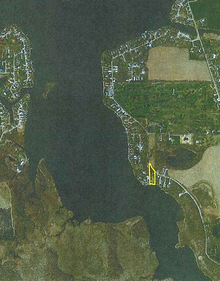
a.
The application and
information contained therein were adequate to allow the DNR to review the
project and any deficiencies in the application were cured.
b.
The site is not
located in an area of special concern as defined in 312 IAC 11-2-2, the area in
question having been dredged in 1948. The shoreline is not in a natural
condition.
c.
Installation of a
concrete seawall at the site will not result in unreasonable detrimental and
cumulative effects upon fish, wildlife, or botanical resources. The evidence in
the record fails to sustain the DNR’s determination on this issue.
d.
Claimant submitted
all information requested by the DNR and Claimant’s application was not
incomplete.
See the Prosser Petition, page 2.
6. The Prosser Petition initiated a proceeding governed by IC 4-21.5-3, commonly referred to as the Administrative Orders and Procedures Act (“AOPA”) and the administrative rules adopted by the Commission at 312 IAC 3-1 to assist with the implementation of AOPA.
7. Prosser and the Department are hereinafter collectively referred to as “the Parties”.
8. Administrative Law Judge (ALJ) Dawn Wilson was appointed under IC 14-10-2-2 to conduct this proceeding and to consider the Prosser Petition as a request for administrative review under AOPA and 312 IAC 3-1.
9. On February 29, 2016, Sean Wooding and Ed Harcourt filed a joint appearance on behalf of the Department.
10. Following the issuance of notice to Prosser and the Department, ALJ Wilson set a Prehearing Conference to be heard on March 17, 2016, in Peru, Indiana.
11. The Notice of Prehearing Conference was also served upon the service list of potentially interested persons, providing interested persons with the opportunity to request continued participation in the proceeding through a courtesy distribution. No person on the service list submitted any request or response.
12. Upon notice by the ALJ, the Prehearing Conference held on March 17, 2016, was converted to a telephonic event and both parties attended. During the Prehearing Conference, Prosser asserted a desire to conduct discovery. Also during the Prehearing Conference, a telephonic Status Conference was set for July 26, 2016.
13. During the Status Conference on July 26, 2016, with both parties present, a telephonic Second Status Conference was set for September 14, 2016, to allow Prosser a full opportunity to complete discovery.
14. The Department’s motion requesting a continuance of the Second Status Conference was granted and the Second Status Conference was reset and heard on September 15, 2016, with both parties present. Due to Prosser’s desire to conduct depositions, a telephonic Third Status Conference was set to be heard on October 27, 2016. Also, during the Second Status Conference the parties were orally notified and it was memorialized that a hearing on the facts was set to be heard on December 14, 2016.
15. Prosser’s motion requesting a continuance of the Third Status Conference was granted and the Third Status Conference was reset and heard on December 7, 2016, with both parties present. The Third Status Conference served as the final status conference.
16. The Department’s motion requesting a continuance of the scheduled hearing date, due to the employment obligations of a former Department employee, was granted and the hearing was rescheduled for February 8, 2017.
17. A hearing of the facts was conducted on February 8, 2017, in Peru, Indiana. Prosser appeared in person and by counsel, Stephen Snyder. The Department appeared by counsel, Sean Wooding[2] and by Jim Hebenstreit, Assistant Director of the Department’s Division of Water. Rodney Neese also appeared. Following the administrative hearing, the Parties were allowed the opportunity to submit written closing arguments or briefs on or before March 13, 2017. On March 13, 2017, Prosser, by counsel Stephen Snyder, submitted Claimant’s Brief and the Department, by counsel Sean Wooding, submitted Respondent Department of Natural Resources’ Post Hearing Brief.
18. Under IC 14-26-2 (sometimes referred to as the “Lakes Preservation Act”) and related rules at 312 IAC 11, the Department is the permitting authority for the placement of seawalls on public freshwater lakes. 312 IAC 11-1-2
19. The Department’s Division of Water coordinates the Department’s permitting functions for the Lakes Preservation Act and 312 IAC 11.
20. Lake Manitou, in Fulton County, is a “public freshwater lake” as defined at IC 14-26-2-3 and 312 IAC 11-2-17 and is listed as such in the “Listing of Public Freshwater Lakes”, Information Bulletin #61 (Sixth Amendment), Indiana Register, http://www.in.gov/legislative/iac/20170201-IR-312170046NRA.xml.pdf (February 1, 2017), page 2.[3]
21. The Commission is the “ultimate authority” for proceedings under AOPA for Department permitting decisions under the Lake Preservation Act. IC 4-21.5-1-15 and IC 14-10-2-3
[VOLUME 14, PAGE 164]
22. As the ultimate authority, the Commission must properly conduct proceedings de novo under IC 4-21.5 and 312 IAC 3-1. Rather than deferring to a Department permitting determination, de novo review requires the Commission to consider and apply proper weight to the evidence. Burke’s Vinyl Seawalls & Reynolds v DNR 11, CADDNAR 345, 346 (2008), citing DNR v United Refuse Co., Inc., 615 N.E.2d 100 (Ind. 1993). Upon completion of a proceeding, the Commission may affirm the initial Department determination. Faulk v. DNR, 11 CADDNAR 272 (2008). The Commission may reverse the Department determination. DNR v. Freeman Orchard Assoc., Inc., 11 CADDNAR 285 (2008). The Commission may amend the Department determination by imposing different conditions. Daniel v. Johnston & Fultz Excavating (Vinyl Seawall), 12 CADDNAR 317 (2011).
23. The Commission has jurisdiction over the subject matter and over the persons of the parties under IC 4-21.5 and rules adopted under 312 IAC 3-1 to assist with the implementation of IC 4-21.5.
FINDINGS OF FACT[4]
24. During the administrative hearing, prior to any testimony, the parties offered stipulated facts. The following stipulated facts were accepted by the ALJ as findings of fact in this proceeding:
a. Prosser is the owner of real property with the following street address: 2920 Country Club Road South, Rochester, Indiana (“2920”).
b. Prosser is the owner of real property with the following street address: 2922 Country Club Road[5] South, Rochester, Indiana (“2922”)
c. The Prosser properties, 2920 and 2922, front on Lake Manitou, a public freshwater lake in Indiana.
25. Prosser purchased 2920 in 2003. See testimony of Prosser. [6]
26. Prosser purchased 2922 in 2010. See testimony of Prosser.
27. Prosser’s current seawall at the 2920 and 2922 shoreline is constructed of riprap. See testimony of Prosser and Exhibit 3.
28. Prosser originally sought the Permit from the Department on August 24, 2015, to construct a “new concrete seawall” on 2922’s 50 feet of shoreline and 2920’s 70 feet of shoreline. See Exhibit 2.
29. The Department denied the Permit on February 1, 2016. The Denial Notice references the following project description: “A new concrete seawall will be constructed across 117' of the applicant’s 117' frontage. The lakeward face of the wall will be located along the lake’s legal shoreline. The existing rip rap will be removed. Details of the plans received at the Division of Water on August 24, 2015, September 30, 2015, October 1, 2015, November 4, 2015 and November 23, 2015.” See Prosser’s Petition, Exhibit A and Exhibit 1.
30. The project description refers to 117 feet of frontage in the Permit denial notice. The initial application submitted by Prosser totals 120 feet of shoreline. The difference in the total length of the proposed construction is not dispositive to any necessary determination or disputed issue in this proceeding.
31. For the convenience of the reader, an aerial photograph of the area of Lake Manitou that includes the Permit area has been reproduced below. The reproduction represents a portion of Exhibit B, admitted in this proceeding. In the lower right portion of the reproduction, 2920 and 2922 are highlighted:
32. James Hebenstreit (“Hebenstreit”) is the Assistant Director of the Department’s Division of Water. Hebenstreit oversees the water rights and water use section of the Division, including permitting. At the time of his testimony, Hebenstreit had been employed by the Department for 43½ years. He began his term of employment with the Department as a Lake Inspector reviewing violations and later developed the water use program. Over the most recent 16 years, Hebenstreit has served the Department as an Assistant Director within the Department’s Division of Water. In this role, Hebenstreit supervises the permitting of shoreline alterations and lake bed construction and enforcement of IC 14-26-2. Hebenstreit reviews proposed construction lakeward of shorelines through various applications. Hebenstreit reviews applications for seawall permits that are at or landward of the legal shoreline of public freshwater lakes and ensures that environmental reviews are completed and considered, when necessary. See testimony of Hebenstreit.
33. Hebenstreit reviewed the Permit application submitted by Prosser. See testimony of Hebenstreit.
34. Shortly after Prosser’s application was filed, Hebenstreit spoke with Prosser who verbally informed Hebenstreit that the area relevant to the application had been dredged. See testimony of Hebenstreit and Prosser.
35. Hebenstreit entered a message into the Department Application Tracking System on December 23, 2015. Hebenstreit stated that much of the lake near the Permit area was covered with wetland vegetation and that, over the years, vegetation was removed creating a larger open water area. In part, the entry states:
…Photographs from the 1940s indicate the presence of a channel along the applicant’s frontage. The photographs also support the fact that portions of this large wetland area were above the lake level: however, without more site specific data it is impossible to tell if the channel along the applicant’s property was cut into higher ground.…we aren’t convinced the area is the upland side of a manmade channel, the [aerial] photographs clearly confirm that the area was dredged and there is no way to determine if that dredging occurred in the lake or created a channel with high ground on both sides. As a result we agreed that we would treat this site as a developed area.
See Exhibit 7.
36. Generally, in the 1940s, dredging was commonly used to open up water for navigation. Before 1947, when the Lakes Preservation Act was passed into law, there was no permit required to dredge. See testimony of Hebenstreit.
[VOLUME 14, PAGE 165]
37. The Department’s predecessor, the Indiana Department of Conservation, approved multiple permit applications in the 1950’s on or adjacent to Lake Manitou. Insufficient evidence was provided to allow a determination as to whether any of the permits were for the Permit area or any area adjacent to the Permit area.
a. In 1956, a permit to Lee Strobe approved dredging a portion of Lake Manitou to “…deepen the channel or lake bed in front of this lot… [and]…if desired cut 30 to 35 feet from the shoreline [and] the point on the east side of the lot…. (base of triangle) then slope the bottom…from the cut to the shoreline on the west side of the lot and to the new shoreline…”
b. In 1957, a permit to Robert Scheid was approved, for property owned by Robert Scheid, to remove muck, aquatic vegetation and debris from the lake bed. “…across the frontage…disposing of the excavated material (by barge) above the normal water level…in the area.”
c. In 1957 and 1958, an additional permit to Robert Scheid was approved to remove “muck and aquatic vegetation” and to “extend or move by dredging or dragline and slackline, the shore line…” This permit covered 600-700 feet of lake frontage.
d. In 1958, a permit to Bryce Burton was approved to remove muck and aquatic vegetation in front of property located near the south end of Lake Manitou.
e. Multiple permits define the shoreline as “the line formed on the bank or shore of the lake by the water surface at its legal average normal level of 778.41 feet, elevation, sea level datum or 8.41 feet, gage reading.”
f. Permitting information does not identify whether the permitted activities actually occurred.
g. Permitting information does not reveal whether approved dredging was designed to increase or decrease any portion of the shoreline of Lake Manitou, including the Permit area.
See Exhibit 7.
38. Multiple permits from the 1950’s, identify the “legal average normal level” for the lake. No specific evidence concerning whether the legal lake level or the shoreline survey elevation for Lake Manitou has been established by a Circuit Court was submitted by either party. In addition, no indicator of the legal shoreline appears on any of the aerial photographs presented in this proceeding. See Exhibit 7 and Exhibits 13-17.
39. Rodney Neese (“Neese”) was employed as a Department surveyor from 1983 until his retirement in 2016. During his term of employment, Neese performed as a Field Surveyor of dams, lakes, swamps and floodways for permitting purposes. Neese also performed as a Department surveyor for proposed seawalls, beginning in 2012 or 2013, until his retirement. At the time of his testimony, Neese was a staff member of the Greencastle Community School Corporation. See testimony of Neese.
40. When Neese was employed by the Department, he reviewed the Permit application. Thereafter, Neese reviewed aerial photographs of Lake Manitou taken in 2011-2013, 1998, 1963, 1957 and 1940.
a. Neese obtained an Indiana Department of Transportation aerial photograph that was taken during the time frame that includes 2011-2013. This photograph was a digital orthometric photograph. Neese drew a red line on the photograph, electronically.
b. Neese rectified aerial photographs that he obtained from the violation and permitting section of the Division of Water. To rectify the photographs, he recreated the photographs to make the photographs the same scale in GIS. Once rectified, he digitally traced and then imposed a red line at the same digital coordinates on all of the rectified photographs.
c. Neese’s purpose in creating the rectified photographs and imposing a red line on each rectified photograph was to generally approximate the shoreline of the Permit area over time.
See testimony of Neese and Exhibits 13-17.
41. The use of aerial photographs to compare a shoreline over time is not an exact science and several factors could impact the accuracy of such an effort.
a. There is a certain amount of error in current aerial photographs that frequently increases for older photographs, especially when the photographs are manipulated and rectified. This error has been identified in prior proceedings before the Commission when aerial photographs were determined to be inaccurate and up to ± 10 feet off, when combined with property lines drawn by a third party. See Xanders v. Nixon Trust, 14 CADDNAR 33 (2015).
b. An inaccurate comparison could also result from:
i. Variations in the amount and variety of vegetation present at the site photographed. Aerial photographs taken at different seasons would likely reveal differences in the appearance of the shoreline based on the presence or absence of vegetation.
ii. The time of year when the photographs are taken. Comparisons would be more accurate for photographs taken at approximately the same time of the year.
iii. The time of day and the shadowing present when photographs are taken.
iv. The current elevation of a lake when photographs are taken.
See testimony of Neese.
42. Photographs taken at the Permit site in September of 2015, within the Technical Evaluation prepared by the Department, reveal masses of vegetation at the shoreline. During the winter, the masses most likely would be absent. This difference could impact the accuracy of a shoreline comparison over time using aerial photographs taken during different seasons. See Exhibit B.
43. While a comparison of the aerial photographs rectified by Neese provides for an approximate comparison of the shoreline of the Permit area, the comparison does not provide an exact comparison. Specifically,
a. The time of year when each photograph was taken is undetermined.
b. Neese observed a difference in the delineation of the approximate shoreline on the 1963 photograph, compared to the photograph from 2011-2013. The difference could be attributed to shadows appearing to the west of objects or a different elevation of water when the photographs were taken.
c. It is unknown whether any of the photographs were taken in times of high water. Neese provided his opinion that the photograph taken in 1963 was taken at a time of high water because he observed that, south of the location of the Permit area, the inlet feeding the lake appeared high enough for boats to traverse. Water levels within other photographs were not identified or otherwise described.
d. In comparing the 1957 photograph to the 2011-2013 photograph, a difference in the delineation of the approximate shorelines could be attributed to accretion. Neese described accretion as the gradual adding of soil or material at a slow pace.
e. The thickness of the red line that Neese added to each photograph covers a width equating to five feet or more. Even though the red line was applied digitally, the width of the line could impact an ability to perform an exact comparison of the shoreline of the Permit area over time.
See testimony of Neese and Exhibits 13-17.
44. In comparing the general shoreline represented by the red line on the photographs taken in 1940 and 1957, Neese concluded that dredging was primarily parallel to the shoreline at the Permit area. Neese’s observation suggests his evaluation that the Prosser shoreline did not appear to be in a significantly different location in the two photographs. See testimony of Neese and Exhibits 16-17.
45. Hebenstreit compared a map dated 1924 that was prepared by the Department’s predecessor, the Department of Conservation and compared it to various aerial photographs. At the Prosser shoreline, Hebenstreit recognized that black areas on the photographs were areas of open water. Hebenstreit determined that dredging could have occurred to remove emergent vegetation or floating vegetation from the shoreline in order to clear the water within the lake. See testimony of Hebenstreit and Exhibit D.
46. Hebenstreit reported that in his experience people may refer to dredging of a channel when they are actually referring to dredging of a lakebed within a lake. See testimony of Hebenstreit.
47. Joseph Mills (“Mills”) was deposed by Prosser on November 17, 2016. Mills did not otherwise provide testimony in this proceeding.
a. In 1947, when Mills was approximately nine years of age, his father owned 200 feet of shoreline. In 1947, his father’s shoreline was dredged, along with 100 feet of shoreline owned by his grandfather and 200 feet of shoreline owned by his uncle. See Exhibit 12, page 3.
b. Mills recalled that the dredging occurred in an area that now includes the Prosser property.
c. Mills reported that his first recollection of the area was that it was weedy. Before dredging, adjacent to the shoreline it was difficult to get a boat through in times of low water. After dredging, the water was deeper and it was easier to get a boat through the area. See Exhibit 12, pages 2, 3 and 7.
d. Mills recalled that the landward of the shoreline was solid but that people could not step on it because it was “just mucky”. See Exhibit 12, page 10.
e. As a child, Mills observed that the crane would sit on mats to keep it from sinking. The crane’s bucket would be thrown out and pulled back to the shore with mud, water, catfish and frogs in it. See Exhibit 12, page 4.
f. Mills opined that the dredging created more shoreline. Even if the recollection of Mills, as a nine year old boy, from approximately 70 years ago, is a valid recollection, Mill’s recollection that the shoreline was lengthened by the dredging was based on his recollection that when the bucket was dragged to the shoreline some portion of the shoreline was also removed by the bucket. Without more, his recollection would not support a conclusion that the length of the shoreline was actually increased by the dredging. Mills’ opinion was based on the faulty assumption that the mere removal of any part of the shoreline would increase the total length of the shoreline around the lake. Mill’s opinion is not accepted as a fact in this proceeding. Exhibit 12, page 5.
g. Mills also recalled that the Department, during an unstated time frame, used a vacuum to remove silt from the lake bed after the Mt. Zion Dam failed. Mills did not state that the Department altered the Lake Manitou shoreline during that dredging. While Mills recalled that the lakebed dredging was designed to create a channel, it is unclear from the evidence whether the dredging actually created a channel. See Exhibit 12, pages 7 and 13.
See Exhibit 12.
[VOLUME 14, PAGE 166]
48. Douglas Sampsel (“Sampsel”) was deposed by Prosser on November 17, 2016. Sampsel did not otherwise provide testimony in this proceeding.
a. During his childhood, Sampsel assisted his father with dredging projects performed by his father on Lake Manitou.
b. Sampsel was approximately 10 years of age when, in 1947, he assisted his father with dredging the lakebed lakeward of the property currently owned by Prosser.
c. Sampsel recalled that he assisted his father, when his father appeared ready to drive up, by hooking mats on a crane. The crane had to sit on mats “because [the ground] was so soft.” Exhibit 11, Page 3.
d. Sampsel recalled that the dredging was performed with the use of a dragline with a 40 foot boom that his father would cast out into the lake. His father would bring the bucket back full of mud, silt and vegetation. Exhibit 11, pages 2-5.
e. When the bucket was pulled back in, it was below the surface of the water and would hit the shoreline. Exhibit 11, Page 5.
f. As a part of the dredging effort, Sampsel’s father “cleaned up the shoreline” to make it straight and sloped, by using new soil when necessary, moving the shoreline a few inches in some places and several feet in others. Exhibit 11, Page 6.
g. Sampsel opined that by straightening the shoreline, his father straightened the shoreline northward and concluded that the straightening created a longer shoreline. Even if the recollection of Sampsel, as a ten year old boy, from approximately 70 years ago, is a valid recollection, Sampsel’s recollection, without more, would not support a conclusion that the shoreline was actually increased by the dredging. Sampsel’s opinion was based on the faulty assumption that straightening of the shoreline would result in an increase the total length of the shoreline around the lake. Sampsel’s opinion and his related conclusion is not accepted as a fact in this proceeding.
Exhibit 11, Page 6.
49. Based on the undisputed recollections of Sampsel and Mills that are deemed to be reliable, it is determined that the lakebed lakeward of the Permit area was dredged in 1947. See Exhibit 11 and 12.
50. Dredging increases the volume of a lake. Dredging does not necessarily increase or decrease the length of the shoreline of a lake. See testimony of Neese.
51. Dredging a lakebed may be completed in a manner that is parallel to a shoreline. Dredging that is completed parallel to a shoreline is not likely to increase the length of a shoreline. See testimony of Hebenstreit and Neese.
52. Dredging has the potential to move the location of a shoreline. See testimony of Hebenstreit.
53. Dredging of the Permit area in 1947 could have moved the shoreline of the Permit area. See testimony of Hebenstreit.
54. The aerial photographs taken in 1940 and 1957 were taken before and after the dredging that occurred in 1947. The photographs provide insufficient clarity and definition to show whether the shoreline of Lake Manitou was increased during the span of time between the two photographs, by dredging or any other means. See Exhibits 15 and 16.
55. A review of an aerial photograph within the Site Inspection-Documentation Checklist reveals that the waterline of the Permit area appears north of the property line at the shore. The property line appears to be submerged at the time of the photograph. The submerged property line could have resulted from dredging of the shoreline or another cause unrelated to dredging, such as high water at the time the photograph was taken. See testimony of Hebenstreit and Exhibit B.
56. In the Department’s Environmental Evaluation report, a biologist made no personal observation during his inspection that would support a conclusion that dredging “resulted in creating additional lake frontage.” See Exhibit C.
57. Following Hebenstreit’s review of information presented to him by Department staff, he concluded that he had insufficient information with which he could conclude that the Lake Manitou shoreline had been lengthened by dredging. See testimony of Hebenstreit.
58. Prosser failed to present sufficient evidence to show that dredging of the Permit area increased the shoreline of Lake Manitou.
59. Prosser referred to the dredged Permit area as a channel and reported that the tax rate for 2920 and 2922 is assessed at a channel property rate. See testimony of Prosser.
60. Hebenstreit was unable to specifically identify a well defined channel for the Permit area.
a. Multiple aerial photographs reviewed by Hebenstreit revealed that the area directly across the water from the Permit area was, most likely, a wetland area with emergent vegetation.
b. In the alternative, the area across the water from the Permit area could also be floating vegetative mats that would have the potential to break off and float.
c. Hebenstreit could not identify an area of “high and dry” ground on the south side of the water, across from the Permit area.
d. Hebenstreit reviewed the Department’s Environmental Review and determined, consistent with the determination of the Department’s biologist, that the Permit area is on the lake itself rather than part of any channel.
e. Hebenstreit determined that the area lakeward of the Permit area includes no defined banks and no well defined channel.
See testimony of Hebenstreit and Exhibit C.
61. A wetland area across the lake from the Permit area, known as the Manitou Islands Nature Preserve, is managed by the Department. See Exhibit C.
62. Prosser acknowledged his understanding that, in 1947, there was significant vegetation in the water on the opposite side of the lake from the dredged area. See testimony of Prosser and Exhibit 12, page 8.
63. Prosser acknowledged the recollection of Sampsel and Mills that the southernmost points where the 1947 dredging was conducted was in water, as far out as the boom could reach, where there was no solid ground. See testimony of Prosser, Exhibit 11, page 4 and 11 and Exhibit 12, pages 4 and 8.
64. While dredging occurred at the shoreline of the Permit area, no well-defined channel that includes the shoreline of the Permit area on one side is revealed by the evidence.
65. As a result of Hebenstreit’ s review of information that was compiled and presented to him by his own staff and the staff of the Department’s Division of Fish and Wildlife, Hebenstreit revised the conclusion he reached in December of 2015[7], that the Permit area was a developed area. Hebenstreit determined that the Permit area was not a developed area, defined as the upland side of a manmade channel for the following reasons:
a. the Permit area reveals no well-defined channel, required to qualify as a watercourse; and
b. because the Permit area is not a watercourse, it does not qualify as a manmade channel.
See testimony of Hebenstreit.
66. In his Petition, Prosser disputes that a concrete seawall at the Permit site would result in unreasonably detrimental and cumulative effects on fish, wildlife, or botanical resources. Prosser, provided no scientific evidence to support his conclusion.
67. Generally, Hebenstreit has observed that the environmental impacts of construction over the past ten to twenty years have become more of a consideration. Hebenstreit refers environmental reviews to the Department’s Division of Fish and Wildlife for completion by a biologist. While every project has an impact, a biologist’s review represents the Department’s recognition that, beyond some point, the impact on fish, wildlife and botanical resources is unacceptable. See testimony of Hebenstreit.
68. If a permit area is listed on the Heritage Database, Department protocol requires an automatic biologist review. While there was a “hit” on the Heritage Database for the Permit area that required a biologist review, no referral was initially made because the “hit” was not originally discovered. When Hebenstreit and his staff discovered that a review was required, a referral was made to the Division of Fish and Wildlife. See testimony of Hebenstreit.
69. Nathan Thomas (“Thomas”), Lakes Permitting Biologist, for the Department’s Division of Fish and Wildlife conducted an inspection of the Permit area and surrounding area on January 26, 2016. See Exhibit C.
70. Following his inspection, Thomas prepared an Environmental Evaluation dated February 1, 2016. In the Environmental Evaluation, Thomas reported his observation of a small amount of cattails adjacent to the Permit area but no emergent vegetation along or lakeward of the shoreline. Through submerged vegetation sampling, Thomas determined that coontail was often present in the area. In the Environmental Evaluation, Thomas observed that: “[d]ue to the time of year of the DFW inspection, no vegetation could be observed in the lake.” See Exhibit C, page 2.
[VOLUME 14, PAGE 167]
71. The Permit area is north of a main inlet where Rain Creek enters the lake. Landward of the shoreline, manicured grass and residential development are present. In the Environmental Evaluation, Thomas reports:
The frontage is not located along a manmade channel and bulkheads are more than 300 ft apart. No emergent vegetation is present lakeward of the shoreline…The landowner claims the project area should be considered as ‘the upland side of a manmade channel.’ While it is not unreasonable to assume that the area lakeward of the shoreline has been dredged, there was no definitive evidence presented to support the fact that the dredging resulted in creating additional lake frontage, or the creation of a watercourse as required in the definition of a ‘manmade channel’ in 312 IAC 11-2-11.8. The project area is on the main body of the lake, though in a shallow area. Therefore, the shoreline classification of the site is ‘area of special concern’. Pursuant to 312 IAC 11-4-2, new seawalls along Areas of Special Concern must be comprised of bioengineered materials or glacial stone. As such, the proposal to install a new concrete wall along this frontage as been determined to be inconsistent with the lakes rules.
Exhibit C, page 2.
72. For a developed area, a biologist would review only the area right in front of a proposed seawall. Based on a determination that the Permit area was a developed area, a biologist review of the environmental effects immediately lakeward of the proposed seawall would not prevent a new seawall of a concrete construction material. See testimony of Hebenstreit.
73. Compared to the environmental review necessary for a developed area, a more expansive environmental evaluation is required for an area of special concern. Thomas’ determination that the Permit area was an area of special concern required him to conduct a more expansive environmental evaluation. Following his review, Thomas recommended that the Permit be “denied due to significant environmental harm and direct and cumulative loss of fish, wildlife, and botanical resources.” See Exhibit C.
74. The reliable evidence included within the Environmental Evaluation of the Permit area supports a denial of Prosser’s application, if the Permit area is determined to be in an area of special concern.
75. A characteristic of an area of special concern is an altered shoreline. Dredging at the shoreline of the Permit area could have altered the shoreline. Even if dredging did not alter the shoreline, the shoreline at the Permit property was altered by placement of the current riprap seawall. See testimony of Hebenstreit.
76. The Permit area is determined to be an altered shoreline.
77. Another characteristic of an area of special concern is the distance between bulkhead seawalls. Bulkhead seawalls in the Permit area are over 300 feet apart. See testimony of Hebenstreit.
78. Prosser acknowledges that in the Permit area bulkhead seawalls are more than 250 feet apart. See testimony of Prosser.
79. Hebenstreit made a determination that the shoreline relevant to the Permit was an area of special concern because the Permit area represents an altered shoreline and the distance between bulkhead seawalls is more than 250 feet. See testimony of Hebenstreit and Exhibit B.
80. The Permit area contains characteristics of an area of special concern.
81. On behalf of the Department, Hebenstreit denied Prosser’s application for the Permit because the application proposed construction of a seawall in an area of special concern using an unapproved material, concrete. Based on Hebenstreit’s determination that the Permit area is an area of special concern, he also determined that the construction material proposed would have an unacceptable cumulative effect upon fish, wildlife and botanical resources. See testimony of Hebenstreit.
CONCLUSIONS OF LAW
Burden of Proof and Standard of Review
82. AOPA provides at IC 4-21.5-3-14(c) in pertinent part that “[a]t each stage of the proceeding, the agency or other person requesting that an agency take action…has the burden of persuasion and the burden of going forward with the proof of the request….” The burden of persuasion and the burden of going forward are sometimes collectively referred to as the “burden of proof”.
83. A person seeking a permit under the Lake Preservation Act has the burden to prove entitlement to the permit. Burke’s Vinyl Seawalls & Reynolds v. DNR, 11 CADDNAR 345, 347 (2008), and, generally, Ind. DNR and NRC v. Krantz Bros. Const., 581 N.E.2d 935 (Ind. App. 1991).
84. The standard of review under AOPA is generally “preponderance of the evidence”. Indiana Dept. of Natural Resources v. United Refuge Company, Inc., 615 N.E.2d 100 (Ind. 1993) and Burke’s Vinyl Seawalls, at 347. “Preponderance of the evidence” refers to evidence which, when considered and compared with that opposed to it, has more convincing force, and which produces in the mind of the trier of fact, a belief that what is sought is more likely true than not. Bivens v. State, 642 N.E.2d 928 (Ind. 1994).
85. Prosser has the burden of proof to demonstrate to the Commission by a preponderance of the evidence that the Department’s denial is in error in that he is entitled to the Permit.
Department Seawall Permitting on Lake Manitou
86. Lake Manitou is a “public freshwater lake” in Fulton County, Indiana. IC 14-26-2-3
87. The Lake Preservation Act prohibits certain activities over, along or lakeward of the shoreline of a public freshwater lake unless the person obtains a permit from the Department and conducts the activity in accordance with the terms of the permit. IC 14-26-2-23(a)
88. One activity that is prohibited without a permit from the Department is to: “Construct a wall whose lowest point would be: (A) below the elevation of the shoreline or water line; and (B) within ten (10) feet landward of the shoreline or water line, as measured perpendicularly from the shoreline or water line; of a public freshwater lake.” IC 14-26-2-23(a)(2)
89. The Lake Preservation Act authorizes the Department to issue a permit after investigating the merits of an application. The Department may consider any factor, including cumulative effects of the proposed activity upon “(1) The shoreline, water line, or bed of the public freshwater lake. (2) The fish, wildlife, or botanical resources. (3) The public rights described in section 5 of this chapter. (4) The management of watercraft operations under IC 14-15-1, et seq.. (5) The interests of a landowner having property rights abutting the public freshwater lake or rights to access the public freshwater lake.” IC 14-26-2-23(c)
90. As authorized by IC 14-26-2-23(e), to implement the Lake Preservation Act, the Commission adopted rules to assist in the administration of the Act.
91. Pursuant to 312 IAC 11-1-2, the Department is authorized to grant, condition or deny a license for an activity under IC 14-26.
92. The construction of a structure requiring a written license issued by the Department includes the construction of a new seawall. 312 IAC 11-3-3(f)
93. A “seawall” is “a manmade structure placed along the shoreline or water line of a public freshwater lake for the purpose of shoreline stabilization.” 312 IAC 11-2-2
94. In Patton and Sedgwick v. DNR, 12 CADDNAR 20 (2009), the Commission summarized its regulatory approach for implementing the Lake Preservation Act regarding the permitting of seawalls on public freshwater lakes. The decision summarizes a “three-tiered approach” as follows:
A ‘natural shoreline’ or a ‘significant wetland’ exhibits the most pristine characteristics. In these areas new seawall construction is limited to bioengineered materials. An ‘area of special concern’ exhibits an intermediate condition, and here a new seawall may be constructed of bioengineered materials or of glacial stone. 312 IAC 11-4-2(c). A ‘developed area’ exhibits the greatest disruption by human activities, and in a developed area a new seawall may be constructed of bioengineered materials, glacial stone, riprap, or an approved bulkhead material. Burke’s Vinyl Seawalls& Reynolds v. DNR, 11 Caddnar 345, 349 (2008). This regulatory approach seeks to preserve and protect public freshwater lakes for the enjoyment of all the public. Portions of shorelines exhibiting ‘natural scenic beauty’, and which are least affected by manmade additions or alterations, are accorded greater protections than those more disrupted. The approach is consistent with the Lakes Preservation Act and particularly IC 14-26-2-5.
Id at 23.
95. A new seawall constructed in an area defined as a “developed area” must be comprised of one, or a combination of, the following materials: bioengineered material, glacial stone, riprap, concrete or steel sheet piling. 312 IAC 11-4-2(d)
96. A new seawall constructed in an area defined as “an area of special concern” must[8] be comprised of bioengineered material or glacial stone. 312 IAC 11-4-2(b)
“Developed Area” or “Area of Special Concern”
97. To support his right to construct a seawall from concrete in the Permit area, Prosser must provide sufficient evidence to support a conclusion that the Permit area is a developed area and that the Department is in error in its determination that the Permit area is in an area of special concern.
98. The Department determined that the Permit area is not a developed area for three reasons.
a. The Permit area lacks defined banks or a well-defined channel.
b. The Permit failed to show that construction, in this instance dredging, increased the total length of the shoreline around the lake.
c. The Permit area has characteristics of an area of special concern.
99. A “developed area” is defined as “the upland side or sides of a manmade channel or an area that does not contain any of the following characteristics: (1) An area of special concern. (2) A significant wetland. (3) A natural shoreline.” 312 IAC 11-2-7.
[VOLUME 14, PAGE 168]
100. The “upland side of a manmade channel” is defined as “those sections of the shoreline along a manmade channel where less than six hundred twenty-five (625) square feet of contiguous emergent vegetation or rooted vegetation with floating leaves are present.” 312 IAC 11-2-27.5
101. Thomas reported in his Environmental Evaluation that he observed no vegetation in the lake. Thomas observed a small amount of cattails adjacent to the Permit area but no emergent vegetation along or lakeward of the shoreline. Thomas also concluded that coontail was often present in the area.
102. Vegetation is revealed within the photographs taken at the Permit site in September of 2015. However, the Environmental Evaluation supports a finding that the Permit area shoreline possessed a level of vegetation at the time of the inspection that qualifies the area as the upland side of a manmade channel pursuant to 312 IAC 11-2-27.5, if the Permit area is determined to be a manmade channel.
103. A "manmade channel" is defined as:
…a watercourse created by mechanical means that connects to the lake at one (1) or more points and by its construction increases the total length of shoreline around the lake. The term does not include any areas within the lake cleared by either chemical or mechanical means that do not result in an increase in the total length of shoreline around the lake.
312 IAC 11-2-11.8
104. For the Permit area to be defined as a manmade channel, construction of a watercourse, connecting to the lake at one or more points, must have increased the total length of the shoreline. In 1947, Lake Manitou was dredged. The dredging involved pulling a dragline along the bottom of the lake to scoop up whatever was in the bottom of the lake at or near the Permit area. There is no admitted evidence showing that the intent of the dredging was to construct a channel for a watercourse.
105. Evidence concerning whether the dredging in 1947 increased the length of the lake includes:
a. A red line imposed on the rectified aerial photographs created by Neese approximates the Prosser shoreline over time. Neese acknowledged that the red line itself approximated five feet in width and attributed various reasons for the visible differences in the location of the shoreline on the rectified photographs, including shadows, varying water levels, the time of year that the photographs were taken and accretion. Neese did not provide evidence to support that the shoreline had been lengthened by the dredging in 1947.
b. Hebenstreit attributed the differences in the apparent location of the shoreline in the aerial photographs to vegetation mats or other vegetation that may or may not have been attached to the lake bed. Hebenstreit did not provide evidence to support that the shoreline had been lengthened by the dredging in 1947.
c. The rectified photographs taken in 1940 and 1957 do not accurately allow a comparison of the shoreline or support a conclusion that the length of the shoreline of the lake was increased in 1947, by dredging or any other means.
d. Thomas reported, following his inspection of the Permit area, that he found no definitive evidence to determine that any potential dredging “resulted in creating additional lake frontage.” See Exhibit C.
e. The Depositions of Sampsel and Mills support a finding that the dredging in 1947 included some alteration of the shoreline to straighten the shoreline at or near the Permit area. Also, as the bucket was brought back to the shoreline, the full bucket would hit the shoreline, removing pieces of the shoreline by that action. However, while the shoreline was minimally impacted by Sampsel’s father straightening the shoreline, the use of new soil in cleaning up the shoreline does not support a finding that the shoreline was lengthened by the 1947 dredging.
106. Evidence does not support a finding that dredging in 1947 increased the length of the shoreline around the lake. Therefore, it is determined that the Permit area is not a manmade channel, as defined by 312 IAC 11-2-11.8.
107. Even if the lake was lengthened by dredging in 1947, for the Permit area to be a manmade channel, the area must also be a “watercourse.”
108. IC 14-8-2-304 defines “Watercourse” as follows:
(a) "Watercourse", for purposes of IC 14-25 through IC 14-29, means a channel that:
(1) has defined banks;
(2) is cut by erosion of running water through turf, soil, rock, or other material; and
(3) has a bottom over which water flows for substantial periods of the year.
(b) The term includes the following:
(1) The upstream and downstream parts of a watercourse that is lost in a swamp or a lake if the watercourse emerges from the swamp or lake in a well defined channel.
(2) A watercourse that has been improved by confining the watercourse in an artificial channel.
109. The Petitioner, in Claimant’s Brief, asserts that the definition of watercourse does not apply to the definition of a manmade channel and states: “the excavation adjacent to the Prosser property was created by mechanical means and could not come within the definition of ‘watercourse’ contained at I.C. 14-8-2-304.” See Claimant’s Brief.
110. The first task when interpreting a statute is to “give its words their plain meaning and consider the structure of the statute as a whole. West v. Office of Indiana Sec'y of State, 54 N.E.3d 349, 353 (Ind. 2016), as cited in ESPN, Inc. v. University of Notre Dame Police Dept. 62 N.E. 3rd 1192, 1195 (Ind. 2016).
111. The definition of watercourse is applicable to the Lakes Preservation Act, IC 14-26, in that the definition is “for purposes of IC 14-25 through IC 14-29”. IC 14-8-2-304.
112. Dredging in 1947 was an excavation lakeward of the Permit area that would not qualify as erosion under IC 14-8-2-308(a).
113. Prosser, in his testimony, affirmed his own belief that the Permit area does not qualify as a watercourse as defined by IC 14-8-2-304(a).
114. The Permit area could qualify under IC 14-8-2-308(b) if the area emerges from a swamp or lake in a well-defined channel. Consideration as to whether the Permit area includes a well-defined channel must be determined.
115. The Environmental Evaluation revealed that the shoreline of the project site was protected by a riprap seawall and that upland of the shoreline was “manicured grass and residential development.” However, the Environmental Report prepared by Thomas reports that he observed no evidence that the mechanical means of dredging created a “watercourse” so that the area met the definition of a “manmade channel” in 312 IAC 11-2-11.8.
116. The Technical Evaluation, the Environmental Evaluation, the Depositions of Mills and Sampsel and the testimony of Hebenstreit support a legal conclusion that there is no well-defined channel in the permit area. The dredging that occurred in 1947 scooped out the lake bed but did not create a channel. The opposite side of the area dredged was fully in the waters of Lake Manitou.
117. The other side of the lake from the Permit area is a wetland or vegetative mat that does not qualify as the opposite side of the upland side of a well-defined channel.
118. A determination was made by Hebenstreit and within the Environmental Evaluation that the Permit area was a part of the lake, not part of a channel within the lake.
119. Whether the Permit area is a part of a well-defined channel or not, the area is part of the lake. In a riparian rights dispute on a channel the Commission determined that the shoreline of a public freshwater lake is “any point in which the lake’s water creates a mark on the land.” The Lake Preservation Act governs construction along an island, to change an island to a peninsula, and within the shoreline whether or not a person performing construction seeks a permit from the Department. Bowyer v. Department of Natural Resources, 944 N.E.2d 972, 989 (Ind. App. 2011), cited in Allen v. LaSalle and DNR, 13 CADDNAR 236, 242 (2014).
[VOLUME 14, PAGE 169]
120. A “channel to a public freshwater lake is part of the lake if the channel’s shoreline is included within the uninterrupted close that includes the main body of the lake and the channel.” Id.
121. Upon a denial of a permit for an underwater beach, the Commission determined, that a “manmade channel or cove connected to a public freshwater lake is part of the public freshwater lake where the shoreline forms an uninterrupted close which includes both the main body of the lake and the channel or cove. Shaul v. DNR and Bailey, 13 CADDNAR 24 (2012) citing Sims, et al. v. Outlook Cove LLC, et al., 10 CADDNAR 258, 266 (2006), affirmed on judicial review by LaPorte Superior Court 4, 46D04-0608-MI-253 (2007). Fultz & Trenmoth v. DNR, 13 CADDNAR 46, 48 (2012).
122. At all points along the shoreline, the Permit area is a part of the lake, regardless of whether the area is also a part of a channel. The Permit area is on the lake.
123. Whether or not the Permit area is a channel for some other purpose, the weight of the evidence supports a finding that there is no well-defined channel for the Permit area, required to qualify the area as a watercourse under IC 14-8-2-304(b).
124. Because the area lakeward of the Permit area is not a watercourse, it does not qualify as a manmade channel.
125. Despite the determination that the Permit area does not qualify as the upland side or sides of a manmade channel, the area could be a developed area if it is an area that does not contain any of the characteristics of an area of special concern. 312 IAC 11-2-7
126. An area of special concern is defined as “an area that contains at least one (1) of the following characteristics: (1) An altered shoreline where bulkhead seawalls are at least two hundred fifty (250) feet apart. (2) Bogs, fens, muck flats, sand flats, or marl beaches identified by the division of nature preserves in the Natural Community Classification System. (3) More than six hundred twenty-five (625) square feet of contiguous emergent vegetation or rooted vegetation with floating leaves.” 312 IAC 11-2-2
127. For purposes of the Lakes Preservation Act, the Commission has determined that an unaltered shoreline is one that does not include lawful permanent structures. 312 IAC 11-2-26
128. The Commission previously determined that a “manmade channel into a public freshwater lake is a structure and placement of a seawall on such a channel would not be upon an unaltered shoreline.” Herr v. DNR, 9 CADDNAR 11, 11 (2001).
129. In T. Lusher, Jr. v. DNR, 11 CADDNAR 137, 141 (2007), a notice of violation following a permit denial by the Department to construct a seawall of sheet steel piling in an area determined to be an area of special concern was affirmed by the Commission. In that matter, deepening of the bed of a lake with the removal of minor projections of the land into the lake was performed by a crane on the land that dug dirt out of the lake and dumped it on the property adjacent to the lake. The construction raised the level of the property landward of the shoreline so it could be built upon. Before the dredging the area was swamp. The change created a defined shoreline and deepened the bed thereby providing a near shore boat lane used by the public for navigation of the channel. In that case, dredging resulted in an altered shoreline.
130. The Commission subsequently clarified its position that dredging that moves a shoreline can cause a shoreline to be altered. “A shoreline is altered if sediments, attributable to a ditch or other watercourse as a result of human intervention, form new land along the former natural shoreline. If dredging is limited to the bed of a lake and does not impact the shoreline, the shoreline is not altered by that dredging.” Peterson & Fultz v. DNR, 13 CADDNAR 16, 18 (2012). See also Fultz & Trenmoth v. DNR, 13 CADDNAR 46 (2012), in which the Commission determined that dredging limited to the lakebed did not impact the shoreline.
131. The Prosser Petition avers that the shoreline of the Permit area is not in a natural condition. The Prosser Petition, in this respect is correct. Alteration of the shoreline by the straightening of the shoreline in 1947 resulted in an altered shoreline.
132. In addition, Prosser’s current riprap seawall is a manmade structure placed along the shoreline or the waterline of Lake Manitou for the purpose of shoreline stabilization. Prosser’s current seawall also resulted in an altered shoreline for the Permit area.
133. No party disputes that the shoreline of the Permit area is an altered shoreline.
134. Hebenstreit determined that there was no bulkhead seawall within 300 feet of the Permit area. The evidence is not refuted that the Permit is for an area where there is a span of over 250 feet between bulkhead seawalls.
135. The Permit area is determined to be an area of special concern under 312 IAC 11-2-2(1), in that it has an altered shoreline where bulkhead seawalls are at least 250 feet apart.
136. Because the Permit area has characteristics of an area of special concern, the Permit area is not a developed area.
137. The Permit area is not a developed area because it is not the upland side or sides of a manmade channel. In addition, the Permit area is not a developed area because it has characteristics of an area of special concern.
Permit Denial
138. Prosser disputes the completeness of his application. This basis for denial rests on the lack of receipt by the Department of an application that includes an allowable construction material. The information included with in the Department’s records appears to be sufficient to enable the Department to reach a decision on the merits of the application. No evidence submitted shows that Prosser’s application was incomplete.
139. The Department’s determination that Prosser’s application was incomplete is in error. This basis for denial of the Permit is not supported by the evidence. This basis for denial of the Permit is reversed.
140. The Permit area is an area of special concern. As an area of special concern, not a developed area, the Department has no authority to issue a license for construction of a new seawall of concrete. 312 IAC 11-4-2(c).
141. Prosser’s application proposes an unallowable construction material for a new seawall in an area of special concern, concrete. Prosser’s application was correctly denied. The material allowable for an area of special concern is limited to glacial stone and bioengineered material.
142. As to the detrimental and cumulative effects of the project upon fish, wildlife or botanical resources, Prosser disputes that determination in his request for administrative review. However, Prosser submitted insufficient evidence to refute the conclusions reached by Thomas during his environmental review.
143. Prosser failed to meet his burden for this issue and the Department’s denial on this basis is supported by the evidence presented through the Environmental Evaluation prepared by Thomas.
144. Prosser failed to meet his burden of proof, by a preponderance of the evidence, to set aside the Permit denial issued by the Department.
145. Prosser is disqualified under 312 IAC 11-4 from receiving a permit to place a concrete seawall along the shoreline of Lake Manitou.
[1] As stated in the Denial Reasons portion of the Denial Notice. The Incomplete Application Notice is not enclosed as a part of this order and was not admitted as evidence in this proceeding.
[2] Ed Harcourt separated from employment with the Department prior to the administrative hearing date.
[3] The Listing of Public Freshwater Lakes, Information Bulletin #61 (Fifth Amendment) http://www.in.gov/legislative/iac/20160127-IR-312160050NRA.xml.pdf (January 27, 2016) was revised during the pendency of this proceeding. Both the Fifth and Sixth Amendments identify Lake Manitou as a public freshwater lake.
[4] Findings of fact that may be construed as conclusions of law and conclusions of law that may be construed as findings of fact are so deemed.
[5] The addresses for 2920 and 2922 Country Club Road were stipulated by the Parties. During the administrative hearing Country Club Road was also referred to as Country Club Drive by the Parties.
[6] Identification of evidence is provided as a reference to testimony or exhibits in the record. The reference may not be exhaustive.
[7] See paragraph 35.
[8]An exception to the requirement for specific materials of a new seawall in an area of special concern may be available to a person who demonstrates “vexing erosion problems” and who satisfies the requirements of 312 IAC 11-5-3. See 312 IAC 11-5-3 and Burke’s Vinyl Seawalls & Reynolds v. DNR, 11 CADDNAR 345, 353-354 (2008). No allegation of applicability for this exception was presented in this proceeding.