CADDNAR
[CITE: Allen v. LaSalle and DNR, 13 CADDNAR 236 (2014)]
[VOLUME 13, PAGE 236]
Cause #:12-176W
Caption: Allen v. LaSalle and DNR
Administrative Law Judge: Lucas
Attorneys: Snyder (Allen); Grossnickle, Gooden (LaSalle); Wells, Wyndham (DNR)
Date: March 19, 2014
FINAL ORDER
(1) The common property line of the Allens property and the Eastern LaSalle property shall be extended a reasonable distance in a straight line into the subject channel and Tippecanoe Lake to identify the boundary of the riparian zones of the Allens and LaSalle.
(2) In the vicinity of the boundary of the riparian zones of the Allens and LaSalle, a reasonable distance for the placement of structures and the mooring of boats does not exceed 23 feet from the eastern shoreline of the subject channel.
(3) The Allens and LaSalle must not place or authorize the placement of a structure or mooring of a boat nearer than eight feet from their common riparian boundary.
(4) The Allens and LaSalle must not interfere with active boating or with the use of their riparian areas by another person for lawful ingress or egress to the shoreline, a pier, or a similar structure.
(5) By May 1, 2014, the Allens and LaSalle must remove any structure or moored boat that does not conform to this Order. This requirement applies to LaSalle’s 150-foot pier and any other nonconforming structure or moored boat.
(6) After April 30, 2014, the Allens and LaSalle must not place or authorize a structure, and must not moor or authorize mooring a boat, which does not conform to this Order.
(7) A violation of this Order is a violation of the Lakes Preservation Act and 312 Ind. Admin. Code § 11 and may be enforced by the DNR. The Allens and LaSalle may enforce this Order in a civil action.
FINDINGS OF FACT AND CONCLUSIONS OF LAW
Statement of the Proceeding and Jurisdiction
1. The proceeding was initiated on September 28, 2012 when Thomas R. Allen and Debbie Allen (the “Allens”) filed their “Petition for Administrative Review” which sought relief with respect to the placement by Holly A. LaSalle (“LaSalle”) of a temporary pier in a channel and the open waters of Tippecanoe Lake in Kosciusko County. Tippecanoe Lake is a “public freshwater lake” that is subject to Ind. Code § 14-26-2 (sometimes referred to as the “Lakes Preservation Act”) and 312 Ind. Admin. Code § 11, rules adopted by the Natural Resources Commission (the “Commission”) to assist with its implementation of the Lakes Preservation Act. Plymate v. Paton and DNR, 13 Caddnar 28 (2012); Pier 343 and Muncie YMCA v. DNR, 12 Caddnar 312 (2011)[1]; and “Listing of Public Freshwater Lakes”, Natural Resources Commission, Information Bulletin #61 (Second Amendment), 20110601-IR-312110313NRA (June 1, 2011), p. 4.
2. The Lakes Preservation Act places full power over public freshwater lakes in the State of Indiana. The State holds public freshwater lakes in trust for all Indiana citizens to preserve the lakes’ natural scenic beauty and for recreational purposes. The Department of Natural Resources (the “DNR”) is the agency responsible for administering the trust. Indiana Dept. of Nat. Res. v. Lake George, 889 N.E.2d 361 (Ind. App. 2008) and Lake of the Woods v. Ralston, 748 N.E.2d 396, 401 (Ind. App. 2001). See particularly Ind. Code § 14-26-2-5.
3. The Commission is the “ultimate authority” for agency determinations under the Lakes Preservation Act, including those derived from competing interests among persons claiming riparian rights or interests in riparian rights that may be sufficient for the placement of piers and similar structures in public freshwater lakes. Ind. Code § 14-10-2-4 and Ind. Code § 14-26-2-23. Lukis v. Ray, 888 N.E.2d 325 (Ind. App. 2008).
4. The Lakes Preservation Act is derived from legislation originating in 1947. Statutory amendments made in 2000 included the addition of Ind. Code § 14-26-2-23. The amendments clarified the Commission is responsible for adopting rules to help implement a licensure program that includes temporary piers. The Commission was also charged with resolving disputes between “the interests of landowners having property rights abutting public freshwater lakes or rights of access to public freshwater lakes.” The Commission is to address “competing riparian interests”. Ind. Code § 14-26-2-23(e) and Ind. Code § 14-26-2-23(f).
5. An administrative law judge was appointed under Ind. Code § 14-10-2-2 to conduct this proceeding. The administrative law judge scheduled the initial prehearing conference for October 19, 2012 and informed the Allens and LaSalle. LaSalle moved to reschedule the initial prehearing conference due to her attorney’s scheduling conflict. The request was granted, the conference was rescheduled for November 2, and the conference was held as rescheduled.
6. During the November 2 conference, LaSalle reported her pier was removed from Tippecanoe Lake with the close of the boating season. The Allens and LaSalle discussed matters pertaining to a site survey and agreed to participate in a telephone status conference on December 14 to determine how to most effectively move forward.
7. On December 14, 2012, the telephone status conference was conducted as scheduled. In addition to the Allens and LaSalle, DNR participated through its attorney. Without objection by the Allens, LaSalle or the DNR, the DNR was added as a party. The Allens, LaSalle, and the DNR are collectively the “parties”.
8. The Commission has jurisdiction over the subject matter and over the persons of the parties.
[VOLUME 13, PAGE 237]
9. On about May 18, 2013, LaSalle returned her pier to Tippecanoe Lake in the same or a similar configuration as the 2012 placement that precipitated the Petition for Administrative Review. The Allens filed a “Motion for Order Requiring Removal of Pier” on May 28, and LaSalle filed the “Respondent’s Response to Claimants’ Motion for Order Requiring Removal of Pier” on May 31. The parties briefed the motion, and they participated with the administrative law judge in a site view on June 24. On June 25, the administrative law judge entered an “Interlocutory Order to LaSalle to Remove Portions of Pier”. With respect to the Interlocutory Order, LaSalle on July 9 filed a “Motion to Correct Error; and Motion to Reconsider and/or Clarify Order”. Oral argument on the motion was scheduled and conducted by telephone on July 15. Also on July 15, the administrative law judge entered a “Nonfinal Order to LaSalle to Remove Portions of Pier” and certified the Nonfinal Order for objections and for a party to seek review by the Commission. No party filed objections, and the Commission’s Secretary issued a “Final Order to LaSalle in Accordance with 312 IAC 11-3-2 to Remove Portions of Pier”. No party sought judicial review from the Final Order issued in accordance with 312 Ind. Admin. Code § 11-3-2.[2]
10. A hearing of the facts was set for Columbia City on August 7 and was conducted as scheduled. Following adjournment, the parties agreed to provide post-hearing briefs by October 31. The “Claimants’ Brief” and LaSalle’s “Argument Brief” were filed on October 31. The DNR did not file a post-hearing brief.
11. Following adjournment on August 7, and as described in an August 12 email, the administrative law judge requested guidance from the parties concerning two evidentiary matters. Guidance was provided in the “Claimants’ Brief” and in LaSalle’s “Argument Brief”. The administrative law judged addressed these matters in an “Interlocutory Order Regarding Admission of Respondent’s Exhibit A and Regarding Status of Channel as a Regulated Drain” entered on November 18. The Interlocutory Order is incorporated by reference into this Nonfinal Order as “Exhibit One”.
12. The parties do not dispute ownership or the riparian status of the Allens and LaSalle. The Allens are the owners of real estate commonly known as 79 EMS T49A in Syracuse, Indiana (the “Allens property”). LaSalle is the owner of real estate generally commonly known as 67 EMS T49A in Syracuse, Indiana (the “Eastern LaSalle property”). The Eastern LaSalle property is adjacent to and north of the Allens property. Both the Allens property and the Eastern LaSalle property front on the east shoreline of a channel leading to Tippecanoe Lake with a portion of the Allens property fronting on the open waters of Tippecanoe Lake. LaSalle is also the owner of seven contiguous parcels in an area which fronts on the west shoreline of the channel and a portion of the open waters of Tippecanoe Lake (the “Western LaSalle property”). The Allens are riparian owners with respect to the Allens property. LaSalle is a riparian owner with respect to the Eastern LaSalle property and the Western LaSalle property. “Claimants’ Brief” p. 1 and LaSalle’s “Argument Brief” pp. 1 and 15. The channel that separates the Allens property and the Eastern LaSalle property from the Western LaSalle property is an inlet to Tippecanoe Lake and is referenced as the “subject channel”. LaSalle direct testimony.
13. The proceeding is ripe for a final disposition by the Commission.
Evidence of Usage of the Subject Channel and Nearby Tippecanoe Lake
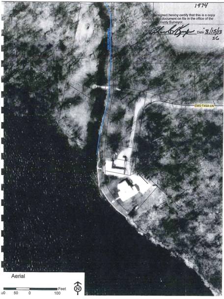
14. The subject channel is a natural inlet to Tippecanoe Lake. The preponderance of the evidence is the subject channel remained in essentially a natural condition until between 1965 and 1974 when it was dredged. The change in character of the subject channel between 1965 and 1974 is illustrated by Claimants’ Exhibit 14 and Claimants’ Exhibit 15. Until dredging, the subject channel was unsuitable for navigation. Claimants’ Exhibits 11 through 16 and Allens cross examination of LaSalle. Claimants’ Exhibit 14 and Exhibit 15 are as follows:
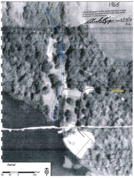
[VOLUME 13, PAGE 238]
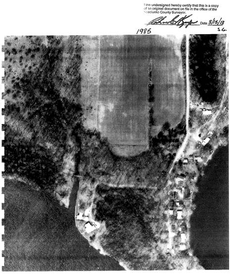
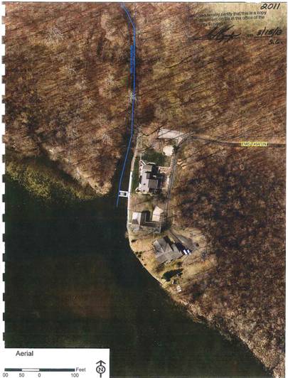
15. In 1985, the subject channel was identified by an aerial photograph (including a bridge over the subject channel that was also visible in 1974 in Claimants’ Exhibit 15) as set forth in Claimants’ Exhibit 16:
16. Holly LaSalle and her late husband, Dr. Robert LaSalle, Jr., purchased the Eastern LaSalle Property in November 1990. At that time, the subject channel “had filled in considerably…. There was no access whatsoever by boat”[3] to Tippecanoe Lake. To create access Holly LaSalle’s “intent was to dredge, which I did.” She participated three times in dredging to maintain the access. As long as she continues to dredge, she can access Tippecanoe Lake. Holly LaSalle direct examination and Allens cross examination of LaSalle.
17. At the expense of LaSalle and her late husband, the subject channel was dredged in 1991. Before the dredging, Holly LaSalle agreed “there was no navigation, so I guess…the dredging is a necessity to have navigation in that area whether it’s by [the subject] channel or lakefront properties.” LaSalle caused dredging in 1991 because she wanted navigational access to Tippecanoe Lake. LaSalle direct and Allens cross examination of LaSalle.
[VOLUME 13, PAGE 239]
18. Again at their expense, LaSalle and her late husband in 1994 dredged the subject channel “to the point”. LaSalle characterized this dredging project as being for maintenance and clean-up. Because the dredging equipment was already on Tippecanoe Lake, she did not have to pay set-up fees. LaSalle direct.
19. Sometime between 1994 and 2000, the Lake Tippecanoe Property Owners Association applied to the DNR for a Lake and River Enhancement grant for land treatment projects on all inlets to Tippecanoe Lakes, including the subject channel. A purpose was to help control sedimentation, and the Lake Tippecanoe Property Owners Association received and implemented the grant. The Hanna B. Walker Drain was rerouted to slow the velocity of water coming into Tippecanoe Lake. LaSalle direct.
20. In 2000, the Lake Tippecanoe Property Owners Association dredged a 20-foot wide segment of the lakebed southwest of the subject channel and dredged a channel into the lake that was 70-feet wide and 400-feet long. LaSalle again paid to dredge the subject channel. “That has held longer than the two previous dredgings,” but subsequently the subject channel “has filled in.” LaSalle direct.
21. Following the 2000 dredging, LaSalle moored a boat at a pier along the eastern shoreline of the subject channel. A U-shaped floating dock with a boat lift was located about 60 feet north of the pier. LaSalle kept a ski boat alongside and moored a pontoon on the front and to the south of the floating dock. LaSalle direct.
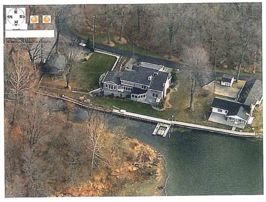
22. The Allens purchased the Allens property in April 2007. LaSalle’s U-shaped floating dock was parallel to the eastern shoreline of the subject channel, and the open end of the U was to the north. The U-shaped floating dock was directly in front of the residence on the LaSalle property. To the south, LaSalle also maintained a pier that extended west-southwest from the eastern shoreline and may have encroached on the Allens property.[4] The site as it existed in the 2007 boating season is depicted in a Google earth aerial photograph:
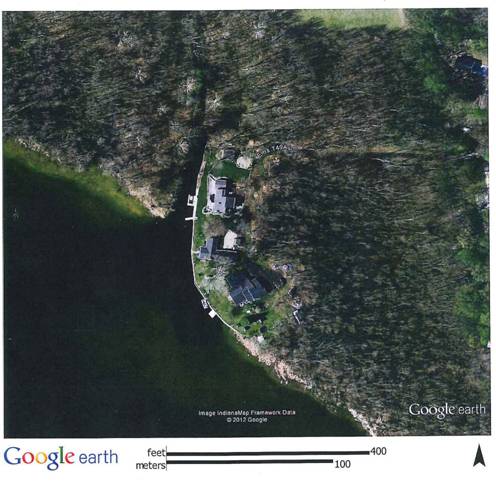
The Allens and LaSalle achieved an agreement with respect to the pier in 2007, which included sharing the pier, and LaSalle later relocated the pier farther north. Claimants’ Exhibit 1 and Thomas Allen direct.
23. In April 2008, LaSalle purchased the Western LaSalle property. Respondents’ Exhibit H.
24. In 2008 when the subject channel “started filling-in,” LaSalle had “more difficulty getting our floating lift to go down so you could get the boat off in the [subject] channel.” LaSalle direct.
25. In about 2010, LaSalle reoriented the U-shaped floating dock so that the open end was to the west. As depicted in Exhibit 22, the reorientation caused the U-shaped floating dock to extend farther into the subject channel than it had in 2007. In addition, LaSalle moved the U-shaped floating dock south so it was adjacent to the common line of the Allens property and the Eastern LaSalle property.
The absence of foliage indicates the photograph was taken other than in the boating season, and the pier is not depicted. Allen direct and Claimants’ Exhibit 22.
[VOLUME 13, PAGE 240]
26. Claimants’ Exhibit 26 is an oblique aerial image taken in 2010 which depicts the mouth of the subject channel on Tippecanoe Lake. In the lower left is a portion of the Western LaSalle property. Near the center of the image is the residence on the Eastern LaSalle property. Along the eastern shoreline is the U-shaped floating dock which was then almost abutting the common line of the Allens property and the Eastern LaSalle property. To the south of the U-shaped floating dock were two white posts to which the Allens tied their pontoon. The two white posts are approximately five feet south of the common property line extended in a straight line into the subject channel. The residence on the Allens property is located on the right edge of the oblique aerial image:
Direct examination of Thomas Allen.
27. In addition to increasing sedimentation another challenge to navigation in the subject channel, and more generally in this area of Tippecanoe Lake, was “aquatic weed growth and algae, and this is a new issue since about 2003-or-4.” The lyngbya genus of algae began to form mats in the subject channel. The mats are one foot to five feet thick. “Once you take a boat into the algae, you lose steering. You suck up the algae. You have no maneuverability so you’re just stuck.” Lyngbya algae are a benthic cyanobacterial genus that can contain toxins which are harmful to humans and animals. LaSalle direct; Beth Nelson Memorandum, July 12, 2013 (Respondent’s Exhibit B).
28. A drought in 2012 reduced significantly the water level in Tippecanoe Lake and the subject channel, as well as other public freshwater lakes in northern Indiana. Thomas Allen direct. LaSalle agreed the 2012 drought had an adverse effect on navigation, “but we already knew we were in trouble before the drought” because you had to stand and jump on the U-shaped floating dock “and then lift the boat up to get it off.” LaSalle testimony.
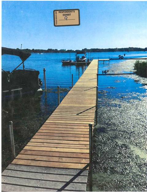
29. In 2012, LaSalle placed a new pier, at an angle from the generally north-south eastern shoreline of the subject channel, in a southeasterly direction and into the open waters of Tippecanoe Lake. The pier was four feet wide and approximately 150 feet long.[5] The U-shaped floating dock was removed from the subject channel and placed at the end of the 150-foot pier and on its south side. About six feet of clearance existed between the Allen’s pontoon boat, which was affixed to the two white posts depicted in Claimants’ Exhibit 26 and described in Finding 26, and LaSalle’s 150-foot pier. Thomas Allen testified the proximity of the 150-foot pier interfered with his attempts to navigate the pontoon into and from the two white posts. The 150-foot pier passed within approximately 14 feet of the shoreline of the Western LaSalle property. An aerial photograph was not available at hearing for 2012 or 2013, but the site is depicted from a ground view in Respondent’s Exhibit Q:
30. Jon Cook, a Conservation Officer with seven years of experience with the DNR’s Division of Law Enforcement, is assigned to Kosciusko County. One of his primary responsibilities is law enforcement on public freshwater lakes, including Tippecanoe Lake. During the boating season he patrols Tippecanoe Lake two or three times monthly. On the average, he performs annually four or five inspections of piers in Kosciusko County with respect to navigation consequences and boating safety. Cook direct.
31. During the drought in the summer of 2012, Officer Cook inspected the subject channel and the 150-foot pier, with emphasis upon potential consequences to boating safety and the environment. Boats in the area are required to be operated at idle speed, and he did not observe hazards to boating safety. The distance between the 150-foot pier and the Western LaSalle property was between ten and 13 feet. With the drought, the area could not be navigated by other than a canoe or small johnboat. Cook prepared a report of his 2012 inspection in a February 27, 2013 Memorandum (DNR Exhibit I). He expounded on the Memorandum during direct. He testified on cross examination by the Claimants, however, that his opinion would have been different had he been aware of the Claimants’ mooring and pontoon boat. See Finding 36.
[VOLUME 13, PAGE 241]
32. Officer Cook testified that if LaSalle kept the 150-foot pier closer to the shoreline when Tippecanoe Lake was at a normal level, a boat other than a large boat could probably navigate into the subject channel. Navigation would be easier without the 150-foot pier.
33. By early spring 2013, the elevations of Tippecanoe Lake and the subject channel had recovered completely from the drought. On June 8, LaSalle photographed a bass boat navigating around the 150-foot pier. “Affidavit of Holly LaSalle” filed June 19, 2013 with six images attached. In the Affidavit, LaSalle stated the images were “offered for consideration in this matter for determination of riparian boundaries of the parties as well as the issue of whether or not the pier…interferes with Claimants’ rights, Claimants’ access to the waters of Tippecanoe Lake or intrusion upon the public’s access to Tippecanoe Lake.” At hearing, however, LaSalle testified the bass boat could navigate the area only because the subject channel was then at “flood stage”. The six images were also introduced at hearing as Respondent’s Exhibit X and Exhibit Y.
34. When dredged, the depth of the subject channel was sloped from the center to the shorelines. Neither a bass boat nor a pontoon boat could pass between the 150-foot pier and the western shoreline at an ordinary water level. Because the subject channel has been filled by sediments and has an algal mat, only a flat bottom boat with no draft and no motor could navigate successfully in 2013. DNR cross of LaSalle.
35. Officer Cook attended the site view on June 24 that is referenced in Finding 9. Tippecanoe Lake was at a higher elevation than when he inspected LaSalle’s 150-foot pier during the summer of 2012. The distance between the 150-foot pier and the Western LaSalle property was a “little wider” than in 2012. He also observed similar conditions in August 2013 when the lake was slightly above normal.
36. When Officer Cook performed his inspections, the Allens’ pontoon boat (depicted in Finding 29 and also depicted in Claimants’ Exhibit 2) was not present. His opinion expressed in Finding 31 and DNR’s Exhibit I would have been different had the pontoon boat been present. The positioning of the 150-foot pier could cause a navigation problem to the Allens when seeking either to enter or to leave the mooring. Wind would also affect navigation of the pontoon boat entering or leaving the mooring. If the length of the 150-foot pier were reduced, the hazard would be lessened to the public entering the subject channel. Cook cross by the Allens.
37. Officer Cook testified LaSalle could extend a pier from the Western LaSalle property into the open waters of Tippecanoe Lake. LaSalle agreed she could extend a pier from the Western LaSalle property but only at additional cost, and the pier would be inconvenient to her residence. A reasonable inference is she owns the bridge (or a similarly located successor bridge) that crosses the subject channel and that was depicted in Claimants’ Exhibits 15 and 16 depicted in Finding 14 and Finding 15. The bridge connects the Western LaSalle property and the Eastern LaSalle property but is in disrepair and would require extensive rehabilitation. DNR cross of LaSalle.
38. Kevin R. Michel is an experienced Indiana registered land surveyor who has previously testified before the Commission. On direct examination and on cross examination by the DNR, he characterized the eastern shoreline of the subject channel as approximating a straight line. The common line of the Allens property and the Eastern LaSalle property intersect the eastern shoreline at an angle that is “close to 90º”. LaSalle testified she concurred with Michel that the terrestrial property line between the Allens and LaSalle reached the shoreline at approximately a perpendicular. See Claimants’ Exhibit 23. Thomas Allen testified similarly.
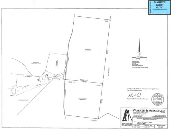
39. Beginning from the point of intersection of the common line of the Allens property and the Eastern LaSalle property with the eastern shoreline, the subject channel is 59 feet wide. A short red line depicts where Michel estimated the 150-foot pier would cross the center of the subject channel, and, as such, what he identified as the transition from the riparian zone for the Eastern LaSalle property to the riparian zone for the Western LaSalle property. Michel testimony applying the survey in Claimant’s Exhibit 44:
Michael agreed that depth patterns within a channel might be significant to determining how far a riparian area extends, but he was not employed to identify the depths of the subject channel and did not identify them.
40. LaSalle testified Debbie Allen objected verbally to LaSalle’s use of the waters, adjacent to the Allen property, for access to LaSalle’s pier and the U-shaped floating dock. She testified the objection was course and claimed exclusivity arising from the Allens’ riparian rights to those waters.[6]
41. In summer 2013, LaSalle wrote a grant application for another dredging study.
Conclusions Based on the Evidence
42. For consideration is a dispute between the Allens and LaSalle that is centered on the location of piers and mooring devices within a channel and the open waters of a public freshwater lake.
43. A riparian owner along a public freshwater lake typically enjoys rights that include: (1) access to the public water; (2) the placement of a pier to the line of navigability; (3) the use of accretions; and (4) reasonable use of the water for purposes such as boating and domestic use. The right to maintain a pier exists only so far out as not to interfere with the rights of the public or with the rights of other riparian owners. Parkison v. McCue, 831 N.E.2d 118, 128 (Ind. App. 2005) for public freshwater lakes, and Center Township Corp. v. City of Mishawaka, 882 N.E.2d 762, 767 (Ind. App. 2008) for navigable waters. See, also, “Riparian Zones within Public Freshwater Lakes and Navigable Waters”, Information Bulletin #56 (Second Amendment) (“Bulletin #56”), p. 2, posted in the Indiana Register at www.in.gov/legislative/iac/20100331-IR-312100175NRA.xml.pdf and admitted into evidence as DNR’s Exhibit II.
[VOLUME 13, PAGE 242]
44. Riparian rights and public “rights can co-exist only if the riparian right to build a pier is limited by the rights of the public and of other riparian owners.” A riparian owner can build a pier, within the extension of the owner’s shoreline boundaries, “only so far out as not to interfere with the use of the lake by others.” Bath v. Courts, 459 N.E.2d 72, 76 (Ind. App. 1984).
45. Acts 1947, c. 181 were antecedent to the Lakes Preservation Act and provided in part:
…For the purpose of this act, the water or shoreline of a public fresh water lake shall mean the normal water line which has existed during the past ten years from the time of the passage of this act where the presence and action of the water are so common and usual as marked upon the soil of the bed a character distinct from that of the banks in respect to vegetation as well as the nature of the soil….
46. Also antecedent to the Lakes Preservation Act were Acts 1947, c. 301, which provided in part:
...The natural resources and the natural scenic beauty of Indiana are declared to be a public right, and the public of Indiana are declared to have a vested right in the preservation, protection and enjoyment of all of the public fresh water lakes, of Indiana in their present state, and the use of such waters for recreational purposes.
...For the purpose of this act, the natural resources of public fresh water
lakes shall mean the water, fish, plant life and minerals and the natural
scenic beauty shall mean the natural condition as left by nature without
man-made additions or alterations.....
....
...It shall be unlawful for any person...to encroach upon the...shore line of any such lakes as now exist...by excavating...below the water or shore line which had existed during the past ten years from the time of the passage of this act, without first securing written approval of the Indiana Department of Conservation [now the DNR].
47. A natural channel or inlet that existed before the 1947 Acts was part of a public freshwater lake as defined by the shoreline that existed between 1937 and 1947. McCulloch v. Day, 12 Caddnar 85, 86 (2009).
48. The term “shoreline or water line” is today defined at IC § 14-26-2-4:
49. The shoreline of a public freshwater lake is “any point in which the lake’s water creates a mark on the land.” The Lakes Preservation Act governs construction along an island, to change an island to a peninsula, and within the shoreline whether or not a person performing construction seeks a permit from the DNR. Bowyer v. Department of Natural Resources, 944 N.E.2d 972, 989 (Ind. App. 2011).
50. A cove connected to a public freshwater lake is part of the public freshwater lake if the shoreline forms an uninterrupted close that includes both the main body of the lake and the cove. Sims, et al. v. Outlook Cove LLC, et al., 10 Caddnar 258, 266 (2006), affirmed on judicial review by LaPorte Superior Court 4, 46D04-0608-MI-253 (2007).
51. A manmade channel or improved inlet “connected to a public freshwater lake is part of the public freshwater lake where the shoreline forms an uninterrupted close which includes both the main body of the lake and the channel….” Fultz & Trenmoth v. DNR, 13 Caddnar 46, 48 (2012).
52. Even though a manmade channel to a public freshwater lake may be navigable only by canoe, the public trust established by Ind. Code § 14-26-2-5 requires its consideration. Shaul v. DNR and Bailey, 13 Caddnar 24 (2012).
53. Since 1947, a person seeking to construct a channel to a public freshwater lake has been required to dedicate any additional water to the public. See now Ind. Code § 14-26-2-23(b)(3). To similar effect for navigable waters is Ind. Code § 14-29-4-5 considered in Carter v. Nugent Sand and Gravel, 925 N.E.2d 356 (Ind. 2010).
54. Whether existing in 1947 or constructed after 1947, a channel to a public freshwater lake is part of the lake if the channel’s shoreline is included within the uninterrupted close that includes the main body of the lake and the channel.
55. Because a lake’s manmade channel or improved inlet is likely to be narrow, and may be compromised by siltation, there may be restrictions on the appropriate placement of piers and mooring of boats. These restrictions may be less significant if the pier is at the end of the channel since the impact to public navigation is of less consequence. Belcher & Belcher v. Yager-Rosales, 11 Caddnar 79 (2007).
56. The subject channel is public and governed by the Lakes Preservation Act. To satisfy the requirements of the Lakes Preservation Act, including those for navigation and to consider the riparian rights of others, the ability to place a pier or to moor a boat may be restricted within the subject channel.
57. “If a lake is significantly above or below its legally established elevation, the observed dimensions may be unsatisfactory.” Id. When evaluating the impact of uses subject to the Lakes Preservation Act, consideration should be based on when a lake or channel is at an ordinary elevation and not during a drought or flood.
58. An evaluation of the impact of LaSalle’s 150-foot pier should be based on when the subject channel was at an ordinary elevation and not during the 2012 drought nor during the flood stage experienced in early June 2013. During the drought, utility of the subject channel was curtailed. During the June 2013 high-water levels, the area between the 150-foot pier and the western shoreline could be negotiated by a bass boat. The better and more instructive period for evaluation was in the summer of 2013 when the subject channel was at an ordinary elevation.
59. Because the subject channel was filled by sediments and an algal mat, LaSalle testified navigation was limited in the summer of 2013 to canoes and johnboats. This usage would be enough to invoke the public trust of the Lakes Preservation Act. Officer Cook testified similarly to LaSalle but expressed the opinion the subject channel could be navigated by other than large boats. Navigation would be easier if not for LaSalle’s 150-foot pier. If the length of the 150-foot pier were reduced, the hazard would be lessened to the public entering the subject channel. During the summer of 2013, convincing evidence is that the subject channel could be navigated by other than larger boats. LaSalle’s 150-foot pier interfered with the rights of public usage of the waters of the subject channel.
[VOLUME 13, PAGE 243]
60. Where the shore approximates a straight line, and where the onshore property boundaries are approximately perpendicular to this line, the boundaries of riparian zones are determined by extending the onshore boundaries into the public waters. Bath v. Courts, 459 N.E.2d 72, 73 (Ind. App. 1984) and the “second principle” in Information Bulletin #56, p. 3.
61. The eastern shoreline of the subject channel approximates a straight line. The common line of the Allens property and the Eastern LaSalle property intersect the eastern shoreline at approximately a perpendicular.
62. The second principle should be applied to delineate the riparian areas adjacent to the Allens property and the Eastern LaSalle property in the vicinity of their common property line. Their common property line should be extended in a straight line into the subject channel.
63. About six feet of clearance exists between the Allen’s pontoon boat, which was affixed to the south side of two white posts depicted in Claimants’ Exhibit 26 and described in Finding 26, and the 150-foot pier. Allen testified proximity of the pier interfered with his attempts to navigate the pontoon into and from the two white posts. The 150-foot pier is almost at the extended common property line for the Allens property and the LaSalle Eastern property. Allen’s two white posts are off-set from the common property line by approximately five feet. Officer Cook testified the 150-foot pier could cause the Allens navigation problems when seeking either to enter or leave the mooring. Wind could also affect navigation of the pontoon boat. These testimonies are persuasive. LaSalle’s 150-foot pier interfered with the rights of neighboring riparian owners, the Allens.
64. Resolution of the riparian dispute is also subject to the “reasonableness” test:
…Instead of a rigid application using a measure of depth or length to determine riparian boundaries, the better view would be to apply a “reasonableness” test to accommodate the diverse characteristics of Indiana’s numerous freshwater lakes.” The reasonableness determination “should be decided on the basis of the facts and circumstances of each particular case so that a court can treat each affected riparian owner equitably.”
Lukis v. Ray, 888 N.E.2d 325, 332 (Ind. App. 2008) citing Zapffe v. Srbeny, 587 N.E.2d 177, 181 (Ind. App. 1992).
65. Citing Zapffe v. Srbeny, the Commission underlined applicability of the reasonableness test in Information Bulletin #56:
A “reasonableness” test is applied to how far a pier may extend from the shore. The installation of a pier by a riparian owner is unreasonable if the pier interferes with the use of a public freshwater lake by others. “One point is well-settled...the boundaries of riparian property do not extend to the middle of the lake….” Any extension of a pier beyond the point required for the mooring and launching of boats may be considered unreasonable.
66. Just as the riparian boundaries do not extend to the middle of a lake, they do not extend to the middle of a channel.[7] Riparian boundaries on opposite sides of a channel in a public freshwater lake cannot be merged to support the placement of a long pier or another obstruction to public navigation. On a public freshwater lake, a pier that merges riparian boundaries from opposite banks gives the appearance and perhaps the reality of a navigational barricade.
67. LaSalle’s positioning of the 150-foot pier forces a member of the public, who may wish to enter the subject channel, to navigate along the western shoreline. A reasonable person may be reluctant to enter what appears a private space. Also, a corridor that is roughly 13 feet wide, and along the western shoreline, is likely to be shallow and problematic for navigation by all but the smallest boats.
68. As a matter of law, the 150-foot pier failed the reasonableness test of Zapffe v. Srbeny, and underlined in Information Bulletin #56, when it crossed the center of the subject channel from the riparian area of the Eastern LaSalle property to the Western LaSalle property.
69. The Commission has ruled that 20 feet of clearance is preferred for boats navigating between structures, but ten feet is sometimes sufficient. Walther, et al. v. Pier 343 Condominium Owners Assoc., 12 Caddnar 16 (2009). A minimum of twelve feet should be maintained for navigation at the center of the subject channel (six feet on both sides of the center). From the point of intersection of the common line of the Allens property and the Eastern LaSalle property with the eastern shoreline, the subject channel is 59 feet wide. At this portion of the subject channel, and applying the centerline of the subject channel as the thalweg, a pier and any mooring should not extend more than 23 feet from either shoreline. As a matter of fact, the 150-foot pier failed the reasonableness test when it extended more than 23 feet from the shoreline of the Eastern LaSalle property.
70. As a riparian owner, LaSalle is generally entitled to cause the placement of a pier to the line of navigability. She is not necessarily entitled to the most convenient access. LaSalle may develop access from the Western LaSalle shoreline, either by rehabilitating the existing bridge over the subject channel or by using a smaller craft for transport to a pier extending from the Western LaSalle shoreline into the open waters of Tippecanoe Lake.
71. Perhaps more importantly, when LaSalle acquired the Eastern LaSalle property access to Tippecanoe Lake did not exist there. The immediate causation was that sedimentation of the subject channel prohibited navigation. But the antecedent causation was the subject channel was developed following dredging of an inlet that did not afford access in its natural condition. A reasonable expectation when she acquired the Eastern LaSalle property was that maintenance dredging would be required for continued access through the subject channel. The expectation has proven a reality. Continued dredging may pose an expensive burden for addressing sedimentation, and the cyanobacterial algal mat is an aggravating circumstance, but it may be a necessity if LaSalle is to enjoy the convenient access she desires to her multiple large boats. Deflecting the burden to the Allens and to the general boating public by installation of LaSalle’s 150-foot pier was unreasonable.
[VOLUME 13, PAGE 244]
72. The common property line of the Allens property and the Eastern LaSalle property should be extended a reasonable distance in a straight line into the subject channel to identify their respective riparian areas. In the vicinity of the common property line, a reasonable distance for the placement of structures and the mooring of boats does not exceed 23 feet.[8] With the narrow conditions existing at the mouth of the subject channel, and considering the history between the Allens and LaSalle, neither party should be authorized to place a structure or to moor a boat nearer than eight feet from their riparian boundary. Riparian rights do not authorize exclusion of the general public or a neighboring riparian owner, and neither the Allens nor LaSalle should interfere with active boating or the use of riparian waters for lawful ingress or egress to the shoreline, a pier, or a similar structure. Any structure or moored boat that does not conform to these requirements should be ordered removed by May 1, 2014 and prohibited from return to Tippecanoe Lake and the subject channel.
“Exhibit One”
INTERLOCUTORY ORDER
REGARDING ADMISSION OF RESPONDENT’S EXHIBIT A
AND REGARDING STATUS OF CHANNEL AS A REGULATED DRAIN
1. Admission of Respondent’s Exhibit A
At hearing, Holly A. LaSalle offered into evidence Respondent’s Exhibit A. The exhibit is a July 31, 2013 “Certification Authorization Affidavit” by Kenneth R. Smith, P.E., Assistant Director for the Division of Water of the Department of Natural Resources. Also, attached to the Affidavit is a January 8, 2013 “Memorandum” from Robert W. Wilkinson, LS, to Eric Wyndham, attorney for the Department of Natural Resources. Wilkinson died on May 19, 2013. The Claimants objected to admission of Respondent’s Exhibit A.
During the hearing, the administrative law judge took the admission of Exhibit A under advisement. Immediately following adjournment on August 7, the parties were invited to brief admissibility. The invitation was memorialized in an August 12 email, with exercise of the invitation to be through the filing and service of briefs by October 31. “Claimants’ Brief” and Respondent’s “Argument Brief” were filed on October 31. The Agency Respondent elected not to file a brief.
312 Ind. Admin. Code § 3-1-10 provides that unless inconsistent with Ind. Code § 4-21.5 or other aspects of 312 Ind. Admin. Code § 3-1, an administrative law judge may apply the Indiana Rules of Evidence. Pierson v. DNR and American Aggregates d/b/a Martin Marietta, 9 Caddnar 19 (2001).
Indiana Rule of Evidence 801(c) defines “hearsay” as “a statement, other than one made by the declarant while testifying at the trial or hearing, offered in evidence to prove the truth of the matter asserted.” Indiana Rule of Evidence 802 indicates “hearsay is not admissible except as provided by law or by these rules.” Indiana Rule of Evidence 803 identifies several hearsay exceptions. Matters which qualify are exempted from the general prohibition on the admission of hearsay.
LaSalle urged Respondent’s Exhibit A is admissible because it qualifies for two exceptions identified in Indiana Rule of Evidence 803. These exceptions are in Indiana Rule of Evidence 803(6) and Indiana Rules of Evidence 803(8).
Indiana Rule of Evidence 803(6) applies to the records of regularly conducted business activity:
A memorandum, report, record, or data compilation, in any form, of acts, events, conditions, opinions, or diagnoses, made at or near the time by, or from information transmitted by, a person with knowledge, if kept in the course of a regularly conducted business activity, and if it was the regular practice of that business activity to make the memorandum, report, record, or data compilation, all as shown by the testimony or affidavit of the custodian or other qualified witness, unless the source of information or the method or circumstances of preparation indicate a lack of trustworthiness. The term “business” as used in this Rule includes business, institution, association, profession, occupation, and calling of every kind, whether or not conducted for profit.
A summary of issues affecting admissibility under Indiana Rules of Evidence 803(6) include factors that should be considered. Among these factors, two that suggest a document should not be admitted include affirmative findings to questions: (1) Was a record was made in anticipation of litigation? (2) “Is this a governmental agency’s factual findings or investigation report that should be analyzed under Rule 803(8) as a public record or report?” Miller, Courtroom Handbook on Indiana Evidence (2001 Ed.), West Group, pp. 273-4. Wilkinson’s Memorandum was made in anticipation of litigation. Smith’s affidavit characterizes the Memorandum as a “public record” of a state agency. The Memorandum is an investigation report. The Memorandum should be analyzed under Indiana Rules of Evidence 803(8) rather than Indiana Rules of Evidence 803(6).
Indiana Rule of Evidence 803(8) applies to public records and reports:
Unless the sources of information or other circumstances indicate lack of trustworthiness, records, reports, statements, or data compilations in any form, of a public office or agency, setting forth its regularly conducted and regularly recorded activities, or matters observed pursuant to duty imposed by law and as to which there was a duty to report, or factual findings resulting from an investigation made pursuant to authority granted by law. The following are not within this exception to the hearsay rule: (a) investigative reports by police and other law enforcement personnel, except when offered by an accused in a criminal case; (b) investigative reports prepared by or for a government, a public office, or an agency when offered by it in a case in which it is a party; (c) factual findings offered by the government in criminal cases; and (d) factual findings resulting from special investigation of a particular complaint, case, or incident, except when offered by an accused in a criminal case.
The hearsay exception for investigation reports in public records is based on the assumption public officials perform duties properly without motive or interest other than to submit accurate and fair reports. Sparkman v. State, 722 N.E.2d 1259, 1263 (Ind. App. 2000). As set forth in the “Certification Authorization Affidavit”, the Memorandum was a public record Wilkinson prepared in the regular course of duties as the Head of the Mapping and Surveying Section of the Division of Water. “Wilkinson regularly prepared reports or memoranda when request to perform riparian boundaries or zones determinations” by the Division of Water or its attorney. Consistent with Smith’s affidavit concerning Wilkinson’s regular course of duties are Lawson v. Halliwill, 13 Caddnar 146 (2013) and Rademaker v. Wells, 12 Caddnar 224 (2010). These citations also underline the trustworthiness of Wilkinson’s expertise.
Documents which are otherwise qualified in Indiana Rule of Evidence 803(8), as exceptions to hearsay, are disqualified by parts (a) through (d). In the Memorandum, Wilkinson applied Commission’s Information Bulletin #56 to his understanding of the configuration of the property lines relative to the lake and channel, based on a Kosciusko County G.I.S. (which he specified yet needed accurate location by a professional land survey). Wilkinson made factual findings resulting from a special investigation of a particular proceeding. As a result, part (d) places the Memorandum outside an exception to the hearsay rule otherwise provided by Indiana Rules of Evidence 803(8). “…[N]ot within this exception to the hearsay rule [are] factual findings resulting from special investigation of a particular complaint, case, or incident, except when offered by an accused in a criminal case.” The proceeding is not a criminal case. The Memorandum does not qualify for an exception to the hearsay rule under Indiana Rule of Evidence 803(8).
[VOLUME 13, PAGE 245]
In one respect, the Indiana Rules of Evidence are inconsistent with Ind. Code § 4-21.5. As provided in Ind. Code § 4-21.5-3-26(a), an administrative law judge may admit hearsay evidence even though it is properly objected to and does not fall within a recognized exception to the exclusion of hearsay. But “the resulting order may not be based solely upon the hearsay evidence.” Respondent’s Exhibit A was properly objected to and does not fall within a recognized exception to the exclusion of hearsay. Pursuant to Ind. Code § 4-21.5-3-26(a), Respondent’s Exhibit A is admitted for the limited purpose of supporting other evidence that has not been excluded.
2. Status of Channel as a Regulated Drain
A portion of the site at issue is within a channel as opposed to the main body of Lake Tippecanoe. Although perhaps not a central matter of evidence, the proceeding included discussion of the channel being potentially part of a regulated drain. In his August 12, 2013 email, the administrative law judge invited the parties to express perspectives concerning the “status of the channel as part of a regulated drain, and, if a regulated drain, any legal consequences.” Again, “the Claimants’ Brief” and Respondent’s “Argument Brief”, both of which were filed on October 31, responded to the invitation. The Agency Respondent elected not to file a brief.
The Claimants urged “[a]ll parties agreed that the channel adjacent to Respondent’s property is part of the Walker Hanna County Regulated Drain.” They cited to Ind. Code § 36-9-27-72(c):
A private crossing, control dam, or other permanent structures may not be placed over or through an open drain unless the plans and specifications for the structure are first approved by the county surveyor. The surveyor shall disapprove the plans and specifications if they do not show that the structure will meet hydraulic requirements that will permit the drain to function properly.
The Claimants concluded “it is unlikely that the pier posts of Respondent’s pier would restrict the hydraulic function of the Walker Hanna ditch, [but] it is possible that the pier, boat lifts and boats moored at the pier could obstruct an otherwise open flow of water. No evidence in this regard was submitted by any party nor, to the knowledge of Claimants, was the [Kosciusko] County Surveyor contacted to obtain his opinion regarding placement of the pier. It is suggested by Claimants that the question of placement of the pier in a public drain is a non-issue.”
The Respondent urged a different view with respect to whether the channel is a regulated drain.
The evidence presented at hearing does not provide much insight for the ALJ to determine whether or not the channel at issue herein is part of a regulated drain. Very little, if any, evidence was submitted on this point by the parties. What little evidence presented at hearing on this issue indicates that the channel is not part of a regulated drain (i.e. a drain maintained by Kosciusko County or State authorities).
The Respondent outlined what they believed to be most germane:
Claimants in their initial Petition for Administrative Review…allege that both they and Respondent are riparian owners and the evidence at hearing supports this. Therefore, Respondent submits that [whether the channel is a regulated drain] is largely, if not entirely, irrelevant to these proceedings and should not have an effect on the outcome…. Further, and for the purposes of these proceedings, the parties, as well as the ALJ, have treated both Claimants and Respondent as riparian owners throughout and Respondent contends that there would have been additional or other measures and proceedings to address this issue specifically prior to trial had it been raised by anyone and/or made a focus of these proceedings.[9]
Although the Claimants and the Respondent have different views regarding whether the channel is a part of a regulated drain, they agreed the issue was irrelevant or nearly so. With these riparian owners and the Department of Natural Resources as parties, a disposition can be made that applies Ind. Code § 14-26-2 and 312 Ind. Admin. Code § 11. Neither the Kosciusko County Surveyor nor a drainage board is a party. Whether the channel is part of a regulated drain is unnecessary to this proceeding. As non-parties, any authority of the Kosciusko County Surveyor or a drainage board would be unaffected.
[1] As provided in Ind. Code § 4-21.5-3-32, an agency is required to index final orders and may rely upon indexed orders as precedent. Caddnar is the Commission’s index of final orders.
[2] See Allen v. LaSalle Application of 312 IAC 11-3-2, 13 Caddnar 191 (2013).
[3] The court reporter has not been requested to prepare a transcript of the hearing. If a witness is shown as quoted in these Findings, the statement is as nearly verbatim as could be determined by the administrative law judge. A stutter or similar repetition may be omitted. If a transcript is subsequently prepared that indicates different wording, the transcript is the official record and a quotation here shall be considered paraphrasing testimony.
[4] The Allens and LaSalle seemingly dispute whether the pier encroached on the riparian area of the Allens property. A disposition of whether an encroachment existed in 2007 is unnecessary to this proceeding.
[5] Both attorneys and witnesses refer to the “150-foot pier” which LaSalle placed for the 2012 boating season. Conservation Officer Cook testified his informal measurements indicated this pier is “slightly less” than 150 feet long. Although not dispositive, the survey depicted in Respondent’s Exhibit D seems to support Cook’s testimony. A pier that is longer than 150 feet from the shoreline of a public freshwater lake is disqualified from a general license and requires an individual license. 312 Ind. Admin. Code § 11-3-1(b)(5). Disqualification of a general license under subdivision (b)(5) is not at issue. For convenience and to conform to the references used at hearing, the new pier placed by LaSalle in 2012 is referenced as the “150-foot pier”.
[6] No conclusion is made concerning the alleged confrontation. LaSalle’s testimony is cited because this Order consequentially addresses temporary usage of riparian waters by neighbors and the public.
[7] The thalweg is the imaginary line that is the deepest part of a channel and the main navigable portion of a waterway. 5 Wester-Mittan, Waters and Water Rights, “Glossary of Water Related Terms”, G-57 (LexisNexis 2009). The construction of a pier or similar structure should not be allowed to interfere with the functionality of the thalweg. The record suggests the subject channel was reconstructed with designed sides sloping to the center (Finding 34) but is insufficient to identify the location of a thalweg. Without using the term “thalweg”, and without applying the concept to his analyses, Michel recognized the limitation to riparian rights posed by the need to preserve a navigable channel. For the purposes of this proceeding, the center of the subject channel is considered equivalent to the thalweg. If a new dredging project is conducted, a thalweg could potentially be designed that provides more flexible alternatives to riparian owners than reference to the center of the subject channel.
[8] Both the Allens and LaSalle enjoy riparian rights along portions of the shoreline of open waters of Tippecanoe Lake which are well outside the subject channel and which would seemingly allow a longer pier or other similar structure that would satisfy the reasonableness test.
[9] Whether the channel is a regulated drain is not thought to determine whether adjoining properties owners have riparian rights. For examples, the Marshall County Drainage Board has claimed for another public freshwater lake “full jurisdiction of all regulated drains flowing into and out of the Lake of the Woods and the Lake of the Woods itself which are part of the Drainage Board’s drainage system….” Drainage Board Resolution No. 2013-02 (March 18, 2013) filed in the Proposed Lake of the Woods Conservancy District, Commission Administrative Cause No. 13-064C. Major portions of the Kankakee River in Indiana are regulated drains. Status as a regulated drain may well add to the complexity of management, particularly for public waters, but the status should not deprive adjoining property owners of riparian rights.