CADDNAR
[CITE: Sowers v. DNR, 13 CADDNAR 143 (2013)]
[VOLUME 13, PAGE 143]
Cause #: 12-126W
Caption: Sowers v. DNR
Administrative Law Judge: Lucas
Attorneys: pro se (Sowers); Wyndham (DNR)
Date: April 24, 2013
FINAL ORDER
The denial by the Department of Natural Resources of the application by Elizabeth Sowers for PL-22092 is affirmed.
FINDINGS OF FACT AND CONCLUSIONS OF LAW
A. Statement of the Proceeding and Jurisdiction
1. On August 9, 2012, Elizabeth A. Sowers (“Sowers”) filed correspondence with the Natural Resources Commission (the “Commission”) in which she sought administrative review under Ind. Code § 4-21.5 (sometimes referred to as the “Administrative Orders and Procedures Act” or “AOPA”) and rules at 312 Ind. Admin. Code § 3-1 from a decision by the Department of Natural Resources (the “DNR”) to deny a license application sought under IC 14-26-2 (sometimes referred to as the “Lakes Preservation Act”) and rules adopted at 312 IAC 11 to assist with implementation of the Lakes Preservation Act. The DNR’s Division of Water administers the licensure provisions of the Lakes Preservation Act and designated the Sowers license application PL-22092. Sowers and the DNR are collectively the “parties”.
2. With the application for PL-22092, Sowers sought authorization to place a 30’ x 20’ underwater beach across 30 feet of her frontage within Jimmerson Lake in Steuben County, Indiana. The underwater beach would consist of a uniform six-inch layer of pea gravel on the lakebed.
3. Jimmerson Lake is a “public freshwater lake” and is subject to the Lakes Preservation Act and 312 IAC 11. McCulloch v. Day & Schramm, 12 Caddnar 40, 41 (2009); Scharlach v. Doswell, 11 Caddnar 420 (2008); Kinder v. Department of Natural Resources, 8 Caddnar 23 (1998); and Halstead v. Department of Natural Resources, 7 Caddnar 71 (1993).[1] See, also, “Listing of Public Freshwater Lakes”, Natural Resources Commission, Information Bulletin #61 (Second Amendment), 20110601-IR-312110313NRA (June 1, 2011), p. 8.
4. The Commission is the “ultimate authority” for administrative review of a licensure disposition under the Lakes Preservation Act. Tersigni v. Osbon & Wright, 13 Caddnar 60 (2012) citing IC § 14-10-2-4 and IC § 14-26-2-23.
5. An administrative law judge was appointed under IC § 14-10-2-2 to conduct this proceeding. The administrative law judge notified the parties of an initial prehearing conference to be held September 28, 2012. The conference was conducted as scheduled. Sowers participated in person, and the DNR participated through its attorney. The parties agreed to exchange information and to participate in a telephone status conference on December 3, 2012.
6. A telephone status conference was conducted as scheduled on December 3, 2012. The parties agreed most or all relevant facts were undisputed and could be stipulated. Sowers sought the application for PL-22092 for a portion of Jimmerson Lake at which the DNR Division of Fish and Wildlife manages a Wetland Conservation Area[2]. The administrative law judge recollected the DNR previously denied applications under the Lakes Preservation Act because projects were in the Wetland Conservation Area, but he was unaware of any person completing administrative review following denial. Sowers expressed an interest in having the Commission adjudicate the consequences of the Wetland Conservation Area. The parties determined and were ordered to complete an exchange of documents and to consider their stipulation into evidence. They also agreed upon a schedule for briefing their legal positions. Documents were exchanged, stipulations were entered, and briefing was completed on April 1, 2013.
7. The Commission has jurisdiction over the subject matter and over the persons of the parties. The proceeding is ripe for disposition.
B. Licensure under the Lakes Preservation Act within the Lake Conservation Area
8. Construction of the original dam for a millpond in Jamestown Township, Steuben County, started soon after 1837. The dam was 14 feet high and had two gates and flumes. Purposes included a woolen mill, grist mill, sawmill, cider mill, blacksmith, distillery, and hydroelectric plant. The grist mill remained in operation until the 1930s when it was sold to the Northern Indiana Public Service Company (“NIPSCO”).[3]
9. On August 30, 1945, NIPSCO sold the millpond to the State of Indiana, for use by the Indiana Department of Conservation (a predecessor to the DNR[4]), through a Warranty Deed that was recorded with the Steuben County Recorder on June 7, 1946.
10. The Warranty Deed from NIPSCO provided in substantive parts as follows:
THIS INDENTURE WITNESSETH that NORTHERN INDIANA PUBLIC SERVICE COMPANY, a corporation organized and existing under the laws of the State of Indiana, conveys and warrants to the STATE OF INDIANA, for and in consideration of the sum of One Thousand Dollars ($1000.00), the receipt whereof is hereby acknowledged, the following described real estate in Steuben County in the State of Indiana, to-wit:
A parcel of land in Section Thirty (30), Township Thirty-eight (38) North, Range Thirteen (13) East, described as follows: Commencing at a point on the west line of said Section Thirty (30), twenty (20) chains south of the northwest corner of said Section Thirty (30), thence east seven (7) chains and seventy-eight (78) links to the north and south highway, thence south to the mill pond at high water mark; thence easterly and southerly following the meanderings of the mill pond to the south line of Section Thirty (30); thence west on the section line about sixteen (16) chains to the west line of the mill pond at high water mark; thence following said mill pond in a northwesterly direction to the northeast corner of a lot conveyed by Wallace Clark to the M. E. Church; thence northwesterly along the north line of said lot and land owned by Jamestown township and lots owned by Neutz to the west line of said Township; thence north seventy-nine (79) links to the place of beginning, including all right-of-flow pertaining to said mill property.
The above described property is convened subject to all unpaid taxes and also subject to any and all existing public highways upon and across the premises conveyed.
The Grantee, by accepting this deed, agrees that the premises conveyed shall not be used for generating and selling electrical energy.
This deed is referred to here as the “DNR Warranty Deed”.
[VOLUME 13, PAGE 144]
11. Sowers and her husband received a Warranty Deed on September 18, 2002 from Gene E. Roady for the property where the license application for PL-22092 would be exercised. This Warranty Deed provided in substantive parts:
THIS INDENTURE WITNESSETH GENE E. ROADY…CONVEYS AND WARRANTS TO RICHARD M. SOWERS and ELIZABETH A. SOWERS, husband and wife, to hold as tenants by the entireties…in consideration of One Dollar ($1.00) and other valuable consideration, the receipt and sufficiency of which are hereby acknowledged, the following Real Estate in Steuben County, State of Indiana, to-wit:
A part of the Southwest Quarter of Section 29, and a part of the Southeast Quarter of Section 30, all in Township 38 North, Range 13 East, Jamestown Civil Township, Steuben County, Indiana, more fully described as follows:
Beginning at a County Surveyor’s monument marking the Southeast corner of Section 30; thence Westerly along the South line of said Southeast Quarter of Section 30, a distance of 113.00 feet to a concrete monument on a stake line near the shore of Jimmerson Lake; thence Northeasterly along said survey stake line a distance of 132.00 feet more or less to a ½ inch rebar marking the South line of real estate described in Deed Record 99-10-0835; thence North 88 degrees 46 minutes 00 seconds East along the South line of said Deed Record 99-10-0835, a distance of 112.00 feet to a 5/8 inch rebar on the Westerly right-of-way of Jimmerson Lake Lane #340; thence South 08 degrees 36 minutes 00 seconds West (assumed basis) along the West right-of-way of said Lane #340, a distance of 129.50 feet to the Point of Beginning, containing 0.34 acre, more or less, within said staked area; but to also include all that real estate lying West of the stake line to the shore of Jimmerson Lake along the side lines extended, subject to any and all applicable legal easements and rights-of-way of record.
Said description is taken from a survey executed by James L. Russell, RLS#11679, State of Indiana, dated April 4, 2002, Job Number 0207-324.
This deed is referred to here as the “Sowers Warranty Deed”.
12. The area within the boundaries of the DNR Warranty Deed is today managed by the DNR’s Division of Fish and Wildlife as a Wetland Conservation Area. The boundary is depicted with a yellow line on an aerial photograph as set forth below:
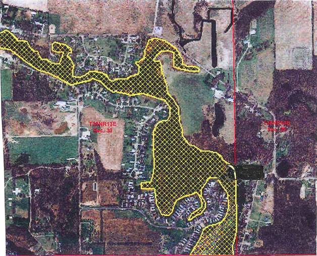
The parties agreed the Sowers Warranty Deed references an area that is immediately outside the yellow line which forms the boundary of the Wetland Conservation Area.
13. The system of law dominant in Great Britain and in the eastern United States, including Indiana, in which owners of lands along a river, stream or lake have the right to reasonable use of the waters, and a correlative right protecting against unreasonable use by others, is riparian doctrine. Spaw v. Ashley, 12 Caddnar 233, 240 (2010).
14. Property rights associated with rivers and streams were traditionally known as “riparian rights”, while those associated with lakes were traditionally known as “littoral rights”. In Indiana, the single term “riparian rights” is today used widely to describe the rights of property owners along rivers, streams, or lakes. Kranz v. Meyers Subdivision Property Owners, 969 N.E.2d 1068, 1081, Footnote 2 (Ind. App. 2012).
15. Reference in the DNR Warranty Deed to a millpond and its boundary at the high water mark is likely a documentary artifact of early regulation of riparian rights through the mill acts. “The mill acts originated in colonial times when waterpower often was the only significant source of energy available to early industry. Waterpower continued to have cost advantages over steam power, at least for smaller mills, late into the nineteenth century.” The primary problem that confronted a would-be mill owner was backflooding behind a dam. “As such backflooding generally constituted a continuing trespass on the land of other owners, the invaded owners could enjoin the backflooding, thereby closing the mill or forcing the mill owner to pay the complaining landowners’ price for the right to backflood.” Although the mill acts imposed restrictions on milldams to protect public interests in the waters, “the primary function of a mill acts was to confer special rights on mill owners. Foremost among those rights was the power to condemn land needed for a milldam, a pond, and a head or tailrace.” Dellapenna, 1 Water and Water Rights, 3rd Ed., §9.02(a) (LexisNexis 2012).
[VOLUME 13, PAGE 145]
16. The record in this proceeding does not disclose how NIPSCO (or a predecessor in title to NIPSCO) acquired the property rights associated with ownership of the millpond and management of the mill. But the State of Indiana purchased NIPSCO’s property rights through the DNR Warranty Deed, and they are now exercised by the DNR in managing the Wetland Conservation Area.
17. In documents filed with the Commission, the DNR describes the pertinent portion of the Wetland Conservation Area as a “54-acre area…within the elevation of 965.84 and is generally the high water mark on a 965-elevation contour.” Jimmerson Lake topographic depiction attached to Respondent Department of Natural Resources’ Filing of Stipulated Documents Provided to Claimant and Statement of Stipulation.
18. Sowers does not contest the geographic delineation of the DNR Warranty Deed or the Wetland Conservation Area. Based on the regulatory definition for an “underwater beach”, she urges the location for which the application for PL-22092 is sought could reasonably be “used for a recreational purpose, such as wading or swimming.” She adds that “[w]ading and swimming are as common to lake usage as boating and fishing, which are both afforded to all individual and allowed by the DNR throughout” the Wetland Conservation Area. “Furthermore, if you look at the purpose of a conservation area, it is to protect and enhance aquatic habitat for fish and wildlife, and to insure the continued viability of public accessible lakes and streams for multiple uses, including recreational opportunities.” Position of Claimant.
19. The Indiana General Assembly changed the legal status of Jimmerson Lake and the millpond with enactment of the Lakes Preservation Act. This enactment was public trust legislation that modified common law riparian rights by recognizing the public’s right to preserve the natural scenic beauty of our public freshwater lakes and the recreational values of the lakes. Indiana Dept. of Nat. Res. v. Lake George, 889 N.E.2d 361, 365 (Ind. App. 2008) citing Lake of the Woods v. Ralston, 748 N.E.2d 396, 401 (Ind. App. 2001).
20. The Lakes Preservation Act is a limitation on the DNR in its capacity as proprietor of the Wetland Conservation Area. The authority of the DNR to control boating, fishing, wading, and swimming within Jimmerson Lake are now balanced by the public’s right to preserve the natural scenic beauty of our public freshwater lakes and the recreational values of the lakes.
21. The Lakes Preservation Act does not extend the geography of one set of property rights over the geography of another set of property rights. The Sowers Warranty Deed does not supersede the DNR Warranty Deed. The DNR has a responsibility in Jimmerson Lake as the trustee for the Lakes Preservation Act and 312 § IAC 11. Its authority for management of the Wetland Conservation Area is a proprietary function derived from the DNR Warranty Deed and not from the Lakes Preservation Act.
22. If Sowers had riparian rights within the Wetland Conservation Area, a hearing of the facts would likely be needed to determine whether DNR’s denial of the application for PL-22092 was unreasonable. Sowers has not demonstrated, however, that she has riparian rights within the Wetland Conservation Area.
23. At its root, the basis for the denial of the application for PL-22092 is not the exercise of a DNR Division of Water regulatory function but rather the recognition of a DNR Division of Fish and Wildlife proprietary function. The Commission lacks a legal basis to set aside Division of Fish and Wildlife’s exercise of this proprietary function.
[1] As provided in IC § 4-21.5-3-32, an agency is required to index final orders and may rely upon indexed orders as precedent. The Commission adopted Caddnar in November 1988 as its index of agency decisions.
[2] The site has been described as the “Jimmerson Lake Wetland Conservation Area” or the “Nevada Mills State Conservation Area or Park” but is here referred to simply as the “Wetland Conservation Area”.
[3] “Reflections on Jimmerson Lake”, Jimmerson Lake Association, PO Box 402, Angola, Indiana.
[4] Ind. Acts 1965, c. 44.