CADDNAR
[CITE: Lawson v. Halliwill, 13 CADDNAR 146 (2013)]
[VOLUME 13, PAGE 146]
Cause #: 10-127W
Caption: Lawson v. Halliwill
Administrative Law Judge: Lucas
Attorneys: pro se (Lawson); Reidy (Halliwill/Dauscher); Patterson (Ellis); Wyndham (DNR); Miller (Schumann); pro se (Schaefer/Hull)
Date: April 26, 2013
FINAL ORDER
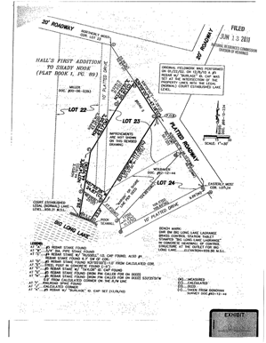
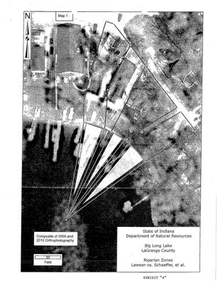
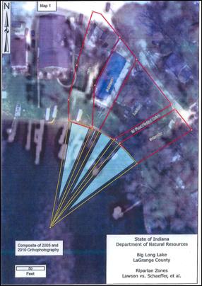
¶1. The delineation of riparian zones among the parties is as described in the Findings of Fact and Conclusions of Law. The delineations are depicted generally as follows:
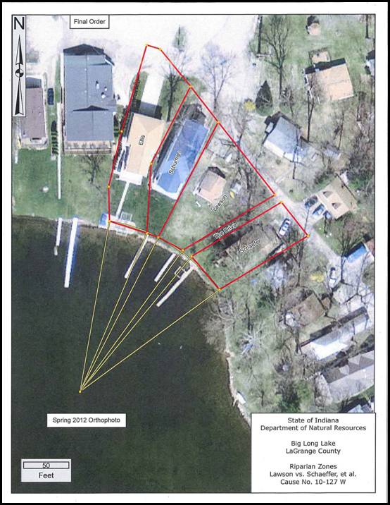
In the depiction, the red lines indicate notable property lines and the boundaries of the Drive landward of the shoreline of Big Long Lake. The yellow curved line approximates the portion of the shoreline needed to determine the lines separating the riparian zones of the parties. The six straight yellow lines that originate from property lines of the parties on the shoreline and the Drive, which converge at the center of the circle referenced in Stipulation 3 of Finding 15, and depict the boundaries of the riparian zones. These include the zone at the terminus of the Drive where the developer of the Shady Nook First Addition and the Shady Nook Second Addition provided an opportunity for pier placement to owners of back lots.
¶2. Except as provided in ¶4, the Final Order inures to the benefit of the heirs and assigns of the parties who are also bound by its terms.
¶3. Except as provided in ¶4, a party may seek to enforce any term of this Final Order through a court of general jurisdiction and preferred venue.
¶4. Application of the “Joint Stipulation of Property Rights” set forth in Finding 11 and the “Joint Stipulation of Property Rights” set forth in Finding 12 are as set forth Finding 11 and Finding 12, respectively.
¶5 To the extent a failure to comply with a term of this Final Order violates the Lakes Preservation Act or 312 IAC § 11, the Department of Natural Resources may seek enforcement through the Lakes Preservation Act or through IC § 14-25.5.
FINDINGS OF FACT AND CONCLUSIONS OF LAW
A. Statement of Proceeding and Jurisdiction
1. Marsha J. Lawson and Jerry M. Lawson (the “Lawsons”) initiated this proceeding on June 30, 2010, under Ind. Code § 4-21.5 (sometimes referred to as the “Administrative Orders and Procedures Act” or “AOPA”) and 312 Ind. Admin. Code § 3-1, when they filed a petition (the “petition”) for a disposition of riparian rights pertaining to usage, and particularly the placement of temporary piers, along a portion of Big Long Lake in LaGrange County.
[VOLUME 13, PAGE 147]
2. Big Long Lake is a “public freshwater lake” as the phrase is defined at Ind. Code § 14-26-2-3 and 312 Ind. Admin. Code § 11-2-17. Spaw v. Ashley, 12 Caddnar 233, 234 (2010).[1] See, also, “Listing of Public Freshwater Lakes”, Natural Resources Commission, Information Bulletin #61 (Second Amendment), 20110601-IR-312110313NRA (June 1, 2011), p. 4.
3. The waters of Big Long Lake within its “shoreline or water line”, as the phrase is used in IC 14-26-2-4, are public waters and subject to IC 14-26-2 (sometimes referred to as the “Lakes Preservation Act”) rules adopted by the Natural Resources Commission (the “Commission”) at 312 IAC § 11 to assist with implementation of the Lakes Preservation Act. Id.
4. The Department of Natural Resources (the “DNR”) is the licensing authority for the Lakes Preservation Act and 312 IAC § 11. Temporary piers and other forms of temporary structures may qualify for a general license if they meet specifications set forth in 312 IAC § 11-3-1. These specifications include that the temporary pier must not infringe on the access of an adjacent landowner to the public freshwater lake and that the temporary pier is placed “by a riparian owner or with the written approval of a riparian owner”. 312 IAC § 11-3-1(b)(2) and 312 IAC § 11-3-1(b)(9).
5. The Commission is the “ultimate authority” for the DNR for licensure decisions under the Lakes Preservation Act. IC § 14-10-2-4 and IC § 14-26-2-23. Lukis v. Ray, 888 N.E.2d 325 (Ind. App. 2008), transfer denied.
6. The DNR and the Commission are responsible for implementing the statutory process of issuing licenses for piers on public freshwater lakes. In adopting rules and issuing licenses, “the DNR is charged with considering a variety of factors, including the public rights listed in [IC § 14-26-2-5] and the interests of landowners who own property abutting the lake.” IC § 14-26-2-23(c) and IC § 14-26-2-23(e)(2). “The DNR is also charged with creating a process ‘for the mediation of disputes among persons with competing interests,’ and the DNR has the authority to resolve the issues if the parties do not reach a settlement.” IC § 14-26-2-23(e)(3). The DNR is charged “generally with enforcing the ‘laws for the conservation and development of the natural resources of Indiana.’” IC § 14-11-1-6. The Commission “has jurisdiction to determine the scope of a lake access easement or riparian rights to the extent necessary to carry out the process of issuing permits for the placement of piers on public freshwater lakes.” Kranz v. Meyers Subdivision Property Owners, 969 N.E.2d 1068, 1078 (Ind. App. 2012).
7. After the petition was filed, an administrative law judge was appointed under IC 14-10-2-2 to conduct a proceeding under AOPA and 312 IAC 3-1. In the course of the proceeding, the Lawsons, Richard D. Schaefer and Marilyn Schaefer (the “Schaefers”); Fred Schuman and Mary Schuman Revocable Trust, Fred Schuman, and Mary Schuman (the “Schumans”); Ron Dauscher and Emily Dauscher (the “Dauschers”); Steve Van Wye and April Van Wye (the “Van Wyes”); Dan Woenker and Anne Woenker (the “Woenkers”); and, Robert Ellis and Cinthia Ellis (the “Ellises”) were identified as parties needed for just adjudication. Each of these persons were served with notice of the proceeding, made a party, and provided an opportunity to participate.
8. The Commission has jurisdiction over the subject matter and over the persons of the parties.
B. Mediation, Stipulations of Property Rights among Particular Parties, and Stipulation of Parties with Respect to Delineation of Riparian Zones
9. The parties agreed to participate in mediation. Sandra Jensen was appointed mediator on December 2, 2010. Although not a party, the DNR also assisted with efforts to achieve an accord among the parties, including sharing the services of Robert W. Wilkinson, LS (“Wilkinson”), who is Head of the Surveying and Mapping Section of DNR’s Division of Water.
10. A mediation session was conducted. The mediator provided an interim report to the administrative law judge on April 12, 2011 that the session resulted in preliminary agreements by some parties for action which she hoped would result in settlement of the proceeding, in whole or in part.
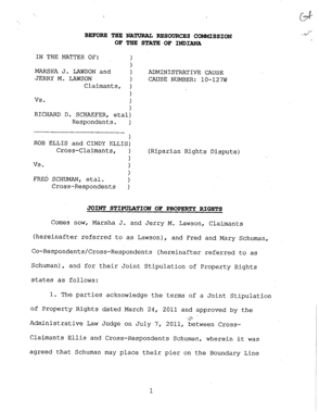
11. On June 13, 2011, a “Joint Stipulation of Property Rights” was filed by the Ellises and the Schumans as follows:
|
|
|
|
|
|
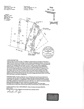
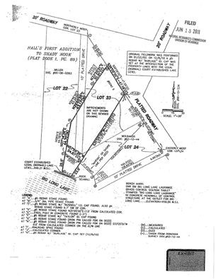
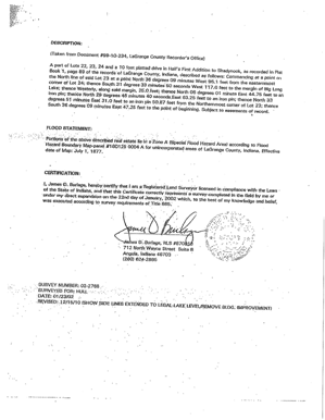
|
|
|
|
|
|
[VOLUME 13, PAGE 148]
A “Notice of Final Order of the Natural Resources Commission approving Joint Stipulation of property Rights among Robert Ellis, Cinthia Ellis, Fred Schuman, and Mary Schuman” was entered and served on the parties on July 7, 2011. No party sought judicial review of this final order.
12. On October 12, 2011, another “Joint Stipulation of Property Rights” was entered between the Lawsons and the Schumans as follows:
|
|
|
|
|
|
|
|
|
|
|
|
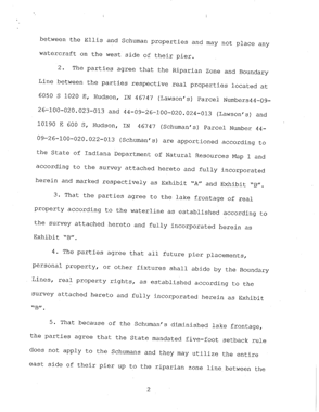
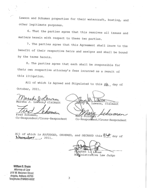
A “Notice of Final Order of the Natural Resources Commission Approving Joint Stipulation of Property Rights among Marsha Lawson, Jerry Lawson, Fred Schuman, and Mary Schuman” was entered and served on the parties on November 21, 2011. No party sought judicial review of this final order.
[VOLUME 13, PAGE 149]
13. During a telephone status conference held on June 16, 2011, the parties agreed that Wilkinson should analyze and delineate particular riparian zones from data provided by the parties. Wilkinson prepared a written report on August 4, 2011 of his analyses and delineations. During a telephone status conference held on November 18, 2011, “the parties agreed and stipulated in principle that the opinion in Wilkinson’s August 4 written report, as depicted by yellow lines within Big Long Lake on Map 1, as the appropriate delineation of riparian boundaries among them.” The stipulation included “the common boundary between the Ellises and the Van Wyes, as well as the common boundary between the Schaefers and the Woenkers. As among the Lawsons, the Schaefers, the Halliwills, and the Dauschers, the delineation of riparian boundaries” was made “subject to a disposition of the ‘Written Narrative of Claim for Access and Rights to Place a Pier’” that was filed on behalf of the Halliwills and the Daushers. The DNR on November 21, 2011 caused the “Filing with Administrative Law Judge of Revised Riparian Zones Report of Robert Wilkinson, LS, Dated August 4, 2011” with the Commission.
14. On November 23, 2011, the administrative law judge entered an “Order Expressing Intention to Approve Stipulation of Parties with Respect to the Delineation of Riparian Zones”. On November 28, the administrative law judge entered an “Order Expressing Intention to Approve Stipulation of Parties with Respect to a Corrected Determination of Riparian Zones”. The parties were provided until December 14, 2011 to file any objection to the six stipulations identified in the two Orders. No party filed an objection.
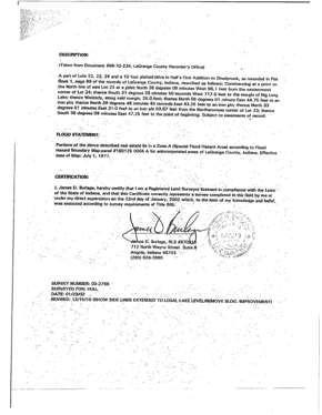
15. On December 20, 2011, an “Order Approving Stipulations of Parties with Respect to the Delineation of Riparian Zones” was entered as follows:
- As
described in these stipulations, the “parties” are Marsha J. Lawson and
Jerry M. Lawson (the “Lawsons”); Richard D.
Schaefer and Marilyn Schaefer (the “Schaefers”);
Fred Schuman and Mary Schuman Revocable Trust, Fred Schuman, and Mary
Schuman (the “Schumans”); Ron Dauscher and Emily Dauscher
(the “Dauschers”); Steve Van Wye
and April Van Wye (the “Van Wyes”); Dan Woenker and Anne Woenker
(the “Woenkers”); and, Robert Ellis and Cinthia Ellis (the “Ellises”).
- Robert
W. Wilkinson, LS, applied “Riparian Zones within Public Freshwater Lakes
and Navigable Waters”, Natural Resources Commission Information Bulletin
#56 (Second Amendment), 20100331-IR-312100175NRA (March 31, 2010) in his
August 4, 2011 report to determine the riparian zones among the parties
within Big Long Lake, LaGrange County, a “public freshwater lake” governed
by IC 14-26-2 and 312 IAC 11.
- To
determine the boundaries of the riparian zones, Wilkinson followed the
part of the Third Principle in Information Bulletin #56 that says the
riparian zones should be perpendicular to the shoreline if that is the
historic practice in the area. Wilkinson followed the part of the
Fourth Principle that says the area of the riparian zones should be
proportionate to the length of the shoreline and the part of the Fourth
Principle that says the riparian zone should be allotted by radial lines
on a round lake. At this location, the curved part of the shoreline
is about one-eighth (1/8) of a circle with a radius of one-hundred
eighty-nine and 76/100ths (189.76) feet.
- Map 1
attached to Wilkinson’s August 4, 2011 report, and also attached here and
incorporated by reference, is an aerial photograph that truly and
accurately depicts the site. The yellow curved line approximates the
portion of the shoreline of Big Long Lake needed to determine the lines
separating the riparian zones of the parties. The six straight
yellow lines that originate from property lines of the parties on the
shoreline, and that converge at the center of the circle referenced in the
previous Finding, depict the riparian zones as determined by Wilkinson.
- Each of
the analyses and conclusions by Wilkinson in Finding 2 through Finding 4
correctly determine the lines between the riparian zones of the parties
applying standard principles used by land surveyors and are consistent
with Information Bulletin #56.
- Shaded
zones described by Wilkinson and depicted within Big Long Lake are
unnecessary to a determination of riparian boundaries and are disregarded
for the purposes of the stipulations. Map 2 and Map 3 are not made
part of these stipulations. Also, as among the Lawsons,
the Schaefers, the Halliwills,
and the Dauschers, the determination of riparian
boundaries in these stipulations is subject to a disposition of the
“Written Narrative of Claim for Access and Rights to Place a Pier” filed
on behalf of the Halliwills and the Dauschers.
Map 1 was incorporated by
reference in the December 20, 2011 Order and is as follows:
In the December 20, 2011 Order, the administrative law judge also stated the stipulations would govern all subsequent stages of this proceeding and would be modified only upon a showing that a modification was required to prevent manifest injustice. No modification was subsequently sought to any stipulation referenced in this Finding.
C. Disposition of Claim by Halliwills and Dauschers for Access and Rights to Place a Pier in the Waters of Big Long Lake Adjacent to the Drive
(i) Summary Judgment Framework
16. Among the Lawsons, the Schaefers, the Halliwills, and the Dauschers, Stipulation 6 of Finding 15 made the stipulations subject to a disposition of the Halliwills’ and the Dauschers’ “Written Narrative of Claim for Access and Rights to Place a Pier”.
17. The parties were notified of a telephone status conference to be held on March 22, 2012. The Lawsons and the Schaefers appeared in person. The Halliwills and the Dauschers appeared through their attorney. Although not a party, the DNR appeared by its attorney. The other parties elected not to participate in the conference or in any subsequent stage of the proceeding pertaining to a disposition of the Halliwills’ and the Dauschers’ “Written Narrative of Claim for Access and Rights to Place a Pier”.
18. During the March 22, 2012 conference, the participating parties agreed and were then ordered to comply with the following schedule for motions of summary judgment pertaining to claims by the Halliwills and the Dauschers for access and rights to place a pier:
(1) Any party may file and serve upon the other parties a motion for summary judgment not later than July 16, 2012.
(2) A party that wishes to respond to a motion for summary judgment made under subpart (1) must file and serve the response by August 15, 2012.
(3) A party that wishes to reply to a response made under subpart (2) must file and serve the reply by August 27, 2012.
The administrative law judge expressed an intention to make an entry with respect to the summary motions by September 27, 2012.
[VOLUME 13, PAGE 150]
19. On May 21, 2012, the Lawsons filed correspondence in which they stated:
We would like to request a motion for summary judgment in this matter. As there has been nothing to indicate any of the parties have factual evidence to add to the previously submitted and included Original Plat of Shady Nook addition recorded 01 May 1911, First Addition 17 April 1914, we see no reason not to move forward to expedite the process and settle this matter.
A document was not attached, and the Lawsons did not under Trial Rule 56(C) designate from the record the document upon which they relied. Perhaps the document for designation was Stipulated Hearing Exhibit One that was attached to the “Report of Telephone Status Conference and Notice of Telephone status Conference” entered on March 22, 2012. This document is also referenced by the Halliwills and Dauschers and so is part of the record for summary judgment.
20. On July 16, 2012, the Halliwills and the Dauschers filed timely the “Respondents’ Motion for Summary Judgment” and the “Respondents’ Memorandum of Law in Support of its Motion for Summary Judgment”.
21. The Lawsons filed timely their “Response to Respondent’s Motion for Summary Judgment of 17 July 2012” on August 14, 2012.
22. The Halliwills and the Dauschers filed timely the “Respondents’ Reply Brief in Support of Their Motion for Summary Judgment” on August 27, 2012.
23. Only the Lawsons, the Halliwills, and the Dauschers participated in the motions for summary judgment.
24. IC § 4-21.5-3-23 governs summary judgment under AOPA and provides:
(b) Except as otherwise provided in this section, an
administrative law judge shall consider a motion filed under subsection (a) as
would a court that is considering a motion for summary judgment filed under
Trial Rule 56 of the Indiana Rules of Trial Procedure.
(c) Service of the motion and any response to the
motion, including supporting affidavits, shall be performed as provided in this
article.
(d) [IC § 4-21.5-3-28 and IC § 4-21.5-3-29] apply
to an order granting summary judgment that disposes of all issues in a
proceeding.
25. Trial Rule 56 of the Indiana Rules of Trial Procedure provides as applied to this proceeding:
(A) For claimant. A party seeking to recover upon a claim, counterclaim, or cross-claim or to obtain a declaratory judgment may, at any time after the expiration of twenty [20] days from the commencement of the action or after service of a motion for summary judgment by the adverse party, move with or without supporting affidavits for a summary judgment in his favor upon all or any part thereof.
(B) For defending party--When motion not required. A party against whom a claim, counterclaim, or cross-claim is asserted or a declaratory judgment is sought may, at any time, move with or without supporting affidavits for a summary judgment in his favor as to all or any part thereof. When any party has moved for summary judgment, the court may grant summary judgment for any other party upon the issues raised by the motion although no motion for summary judgment is filed by such party.
(C) Motion and proceedings thereon. The motion and any supporting affidavits shall be served in accordance with the provisions of Rule 5. An adverse party shall have thirty (30) days after service of the motion to serve a response and any opposing affidavits. The [administrative law judge] may conduct a hearing on the motion. However, upon motion of any party made no later than ten (10) days after the response was filed or was due, the [administrative law judge] shall conduct a hearing on the motion which shall be held not less than ten (10) days after the time for filing the response. At the time of filing the motion or response, a party shall designate to the [administrative law judge] all parts of pleadings, depositions, answers to interrogatories, admissions, matters of judicial notice, and any other matters on which it relies for purposes of the motion. A party opposing the motion shall also designate to the [administrative law judge] each material issue of fact which that party asserts precludes entry of summary judgment and the evidence relevant thereto. The judgment sought shall be rendered forthwith if the designated evidentiary matter shows that there is no genuine issue as to any material fact and that the moving party is entitled to a judgment as a matter of law. A summary judgment may be rendered upon less than all the issues or claims, including without limitation the issue of liability or damages alone although there is a genuine issue as to damages or liability as the case may be. A summary judgment upon less than all the issues involved in a claim or with respect to less than all the claims or parties shall be interlocutory unless the [administrative law judge] in writing expressly determines that there is no just reason for delay and in writing expressly directs entry of judgment as to less than all the issues, claims or parties. The court shall designate the issues or claims upon which it finds no genuine issue as to any material facts. Summary judgment shall not be granted as of course because the opposing party fails to offer opposing affidavits or evidence, but the [administrative law judge] shall make its determination from the evidentiary matter designated to the [administrative law judge].
(D) Case not fully adjudicated on motion. If on motion under this rule judgment is not rendered upon the whole case or for all the relief asked and a trial is necessary, the [administrative law judge] at the hearing of the motion, by examining the pleadings and the evidence before it and by interrogating counsel, shall if practicable ascertain what material facts exist without substantial controversy and what material facts are actually and in good faith controverted. It shall thereupon make an order specifying the facts that appear without substantial controversy, including the extent to which the amount of damages or other relief is not in controversy, and directing such further proceedings in the action as are just. Upon the trial of the action the facts so specified shall be deemed established, and the trial shall be conducted accordingly.
(E) Form of affidavits--Further testimony--Defense required. Supporting and opposing affidavits shall be made on personal knowledge, shall set forth such facts as would be admissible in evidence, and shall show affirmatively that the affiant is competent to testify to the matters stated therein. Sworn or certified copies not previously self-authenticated of all papers or parts thereof referred to in an affidavit shall be attached thereto or served therewith. The [administrative law judge] may permit affidavits to be supplemented or opposed by depositions, answers to interrogatories, or further affidavits. When a motion for summary judgment is made and supported as provided in this rule, an adverse party may not rest upon the mere allegations or denials of his pleading, but his response, by affidavits or as otherwise provided in this rule, must set forth specific facts showing that there is a genuine issue for trial. If he does not so respond, summary judgment, if appropriate, shall be entered against him. Denial of summary judgment may be challenged by a motion to correct errors after a final judgment or order is entered.
(F) When affidavits are unavailable. Should it appear from the affidavits of a party opposing the motion that he cannot for reasons stated present by affidavit facts essential to justify his opposition, the [administrative law judge] may refuse the application for judgment or may order a continuance to permit affidavits to be obtained or depositions to be taken or discovery to be had or may make such other order as is just.
(G) Affidavits made in bad faith. Should it appear to the satisfaction of the [administrative law judge] at any time that any of the affidavits presented pursuant to this rule are presented in bad faith or solely for the purpose of delay, the [administrative law judge] shall forthwith order the party employing them to pay to the other party the amount of the reasonable expenses which the filing of the affidavits caused him to incur, including reasonable attorney’s fees….
(H) Appeal-Reversal. No judgment rendered on the motion shall be reversed on the ground that there is a genuine issue of material fact unless the material fact and the evidence relevant thereto shall have been specifically designated to the [administrative law judge].
(I) Alteration of Time. For cause found, the [administrative law judge] may alter any time limit set forth in this rule upon motion made within the applicable time limit.
[VOLUME 13, PAGE 151]
26. Summary judgment should be granted if the evidentiary material shows there is no genuine issue of material fact, and the moving party is entitled to judgment as a matter of law. Auto-Owners Insurance Co. v. United Farm Bureau Insurance Co., 560 N.E.2d 459 (Ind. App. 1990).
27. In determining if a genuine issue of material fact exists to preclude summary judgment, all doubts must be resolved against the nonmoving party. Facts set forth by a party opposing the motion must be taken as true. Terry v. Indiana State University, 666 N.E.2d 87 (Ind. App. 1996).
28. “A fact is ‘material’ for summary judgment purposes if it helps to prove or disprove an essential element of the plaintiff’s cause of action.” Graham v. Vasil Management Co., Inc. 618 N.E.2d 1349 (Ind. App. 1993). “A factual issue is ‘genuine’ for purposes of summary judgment if the trier of fact is required to resolve an opposing party’s different versions of the underlying facts.” York v. Union Carbide Corp., 586 N.E.2d 861 (Ind. App. 1992).
29. Supporting and opposing summary judgment affidavits must present admissible evidence that follows substantially the same form as though the affiant were giving testimony in court. Capital Drywall Supply, Inc. v. Jai Jagdish, Inc., 934 N.E.2d 1193 (Ind. App. 2010).
30. “The purpose of summary judgment is to terminate litigation about which there can be no factual dispute and which may be determined as a matter of law.” Wells v. Hickman, 657 N.E.2d 172, 175 (Ind. App. 1995).
31. Summary judgment is a lethal weapon. In considering whether to grant summary judgment, the adjudicator must consider its aims and targets and must avoid overkill. Hutchens v. MP Realty Group-Sheffield Square Apartments, 654 N.E.2d 35 (Ind. App. 1995), trans. denied. Caution must be exercised to ensure a party the right to a fair determination of genuine issues. E.Z. Gas, Inc. v. Hydrocarbon Transp., Inc., 471 N.E.2d 316 (Ind. App. 1984).
32. A party moving for summary judgment has the burden of proof with respect to summary judgment, regardless of whether the party would have the burden in an evidentiary hearing. Regina Bieda v. B & R Development and DNR, 9 Caddnar 1 (2001). See, also, Jarboe v. Landmark Community Newspapers, 644 N.E.2d 118, 123 (Ind. 1994).
33. Once the party moving for summary judgment establishes a lack of material fact, the party responding to the motion must disgorge sufficient facts to show the existence of a genuine triable issue. Cowe by Cowe v. Forum Groups, Inc. 575 N.E.2d 630, 633 (Ind. 1991).
(ii) Issuance of Partial Summary Judgment
34. On September 21, 2012, the administrative law judge found the proceeding was ripe for consideration of summary judgment and entered a “Nonfinal Order of Partial Summary Judgment with Findings”.
35. In the “Nonfinal Order of Partial Summary Judgment with Findings”, the administrative law judge concluded the matters in Finding 36 through Finding 45 were not in material dispute, and summary judgment should be granted with respect to them. The conclusion is now affirmed, and final summary judgment is granted with respect to the matters in Finding 36 through Finding 45.
36. The Lawsons and the Schaefers own land adjacent to Big Long Lake and are riparian owners. More particularly, the Lawsons own Lot 24 and the own Schaefers Lot 25 on the opposite sides of a ten-foot wide platted drive (the “Drive”) in Hall’s First Addition to Shady Nook (“Shady Nook First Addition”). Order Approving Stipulations of Parties with Respect to the Delineation of Riparian Zones” (December 20, 2011) with attachment; Stipulated Hearing Exhibit One (March 22, 2012); and “Respondents’ Memorandum of Law in Support of Its Motion for Summary Judgment (July 16, 2012), p. 2.
37. The Shady Nook First Addition was recorded with the LaGrange County Recorder on April 17, 1914. The Shady Nook Second Addition was recorded with the LaGrange County Recorder on April 27, 1916. Stipulated Hearing Exhibit One (March 22, 2012).
38. The northeast end of the Drive terminates at a twenty-foot wide drive that runs generally from northwest to southeast. The Drive also forms the northeasterly boundaries of Lot 24 and Lot 25. The southwest end of the Drive terminates at the shoreline of Big Long Lake. Stipulated Hearing Exhibit One (March 22, 2012).
39. The Dauschers own Lot 63 through Lot 66 and Lot 73 through Lot 77 (the “Dauscher Lots”) of Hall’s Second Addition to Shady Nook (“Shady Nook Second Addition”). Affidavit of Ronald E. Dauscher (November 7, 2011) (the “Dauscher Affidavit”) attached to Respondent’s Motion for Summary Judgment.
40. The Halliwills own Lot 67 and Lot 68 (the “Halliwill Lots”) in the Shady Nook Second Addition. Affidavit of Erika S. Halliwill (November 7, 2011) (the “Halliwill Affidavit”) attached to Respondent’s Motion for Summary Judgment.
41. Lot 63 through Lot 68 and Lot 73 through Lot 77 are not adjacent to Big Long Lake. Neither the Dauschers nor the Halliwills are riparian owners. Stipulated Hearing Exhibit One (March 22, 2012).
42. Ronald Dauscher purchased Lot 66 in 1962 and has owned all the Dauscher Lots since 1979. Dauscher Affidavit.
43. The Halliwills have owned the Halliwill Lots since June 6, 2008. Halliwill Affidavit.
44. Since 1954, the Drive has been used continuously for access to Big Long Lake by
(A) the Dauschers and the previous owners of Lot 63 through Lot 66 and of Lot 73 through Lot 77; and
(B) the Halliwills and the previous owners of Lot 67 and Lot 68. Dauscher Affidavit.
45. Also, since 1954, the owners of the Dauschers Lots and the owners of the Halliwill Lots have placed piers within the shoreline of Big Long Lake adjacent to the southwestern terminus of the Drive. Dauscher Affidavit.
(iii) Facts in Material Dispute following Partial Summary Judgment and their Legal Relevance
46. In the “Nonfinal Order of Partial Summary Judgment with Findings”, the administrative law judge identified legal and factual issues. He concluded the factual matters in Finding 47 through Finding 54 were in material dispute and required an evidentiary hearing before disposition.
47. A determination that the Dauschers and the Halliwills are not riparian owners “does not settle the question of whether they are entitled to install and use” a pier. An easement may convey this right to the dominant estate. Klotz v. Horn, 558 N.E.2d 1096, 1097 (Ind. 1990), citing Farnes v. Lane, 281 Minn. 222, 161 N.W.2d 297, 301 (Minn. 1968). “The issue is not whether the easement holder attains riparian ownership status, but rather, whether he is entitled to use the riparian rights of the servient tenant who has given him access to the body of water bordering the servient estate.” Emphasis supplied by court in Klotz at 1097.
48. The intentions of a riparian owner that grants an easement are to be implemented in construing the easement. In a plat or other recorded conveyance, clear language controls. “Dominant owners of lakeside easements may gain the rights to erect and maintain piers, moor boats and the like by the express language of the creating instrument.” Klotz at 1097 and 1098. The Commission determined a right-of-way for lake ingress and egress and “for the maintenance of a boat and swimming pier” expressed a clear intent and established the right to place a pier, even though the right-of-way was only three feet wide. Havel & Stickelmeyer v. Fisher, et al. at 11 Caddnar 110, 117 (2007). An easement six feet wide for a “boat landing” was found unambiguous and to provide a right to place a pier in Spaw v. Ashley, 12 Caddnar 233 (2010), affirmed on judicial review in Ashley v. Spaw, Allen Circuit Court, Cause No. 02CO1-1008-MI-1178 (2011).
49. The status of the law regarding easements was summarized in Parkison v. McCue, 831 N.E.2d 118, 128 (Ind. Ct. App. 2005):
Easements burdening land with riparian rights attached do not necessarily provide the easement holder use of these riparian rights. Brown v. Heidersbach, 172 Ind. App. 434, 441, 360 N.E.2d 614, 619-20 (1977). Instead, we first look to the express language of the easement. Klotz v. Horn, 558 N.E.2d 1096, 1097-98 (Ind. 1990). “An instrument creating an easement must be construed according to the intention of the parties, as ascertained from all facts and circumstances, and from an examination of all its material parts.” Brown, 172 Ind.App. at 441, 360 N.E.2d at 620. Courts may resort to extrinsic evidence to ascertain the intent of the grantors creating the easement only where the language establishing the easement is ambiguous. Gunderson v. Rondenelli, 677 N.E.2d 601, 603 (Ind.Ct.App. 1997) (citing Klotz, 558 N.E.2d at 1098). A deed is ambiguous if it is susceptible to more than one interpretation and reasonably intelligent persons would honestly differ as to its meaning. See Abbey Villas Dev. Corp. v. Site Contractors, Inc., 716 N.E.2d 91, 100 (Ind. Ct.App. 1999), trans. denied.
[VOLUME 13, PAGE 152]
50. “[G]enerally, access to a body of water is sought for particular purposes beyond merely reaching the water, and where such purposes are not plainly indicated, a court may resort to extrinsic evidence to assist the court in ascertaining what they may have been.” Klotz v. Horn at 1098 citing Badger v. Hill, 404 A.2d 222, 226 (Me. 1979). If the Commission determines the intent of an access from back lot owners to the shoreline of a public freshwater lake is ambiguous, the Commission may apply extrinsic evidence to determine the intent. Adochio, et al. v. Kranz, et al., 11 Caddnar 400 (2008) considered favorably in Kranz v. Meyers Subdivision Property Owners cited previously.
51. A developer may intend to establish a road within a plat either for the private use of the residents of the addition or for general public use. A dedication for public use of a road adjacent to a public freshwater lake can be accomplished by common law or by statute. Altevogt v. Brand, 963 N.E.2d 1146, 1150 (Ind. App. 2012).
52. If access to a public freshwater lake is through a platted public road, an off-lake lot owner has no greater right to use the public road than any member of the general public. The easement is public and not private. Use of a public road to access the lake is a permitted use under the public easement and a non-exclusive right shared with the public. An off-lake landowner does not typically acquire the rights, even following continuous usage in excess of 20 years, to place a pier at the terminus of a public road on the shoreline of a public freshwater lake. A prescriptive easement is not established because the use is not exclusive. A person’s exercise of access rights “under a public easement is not exclusive precisely because that right is shared with others.” Bass v. Salyer, 923 N.E.2d 961, 969 (Ind. App. 2010). The Commission recently cited Bass as controlling in Plymate v. Paton and DNR, 13 Caddnar 28, 33 (2012).
53. Abbs v. Town of Syracuse, 655 N.E.2d 114 (Ind. App. 1995) considered the intent of a public easement and whether the local governmental unit may exercise riparian rights where a street or alley terminates on the shoreline of a public freshwater lake. The court concluded a factual basis could be established for the public dedication of a road that included a right in the government unit to govern the placement of piers. The Court of Appeals ruled an adequate basis was not made on summary judgment to support such a finding in favor of the town and remanded the action to the trial court for an evidentiary hearing. But in this proceeding, the local unit of government (presumably the Board of Commissioners of LaGrange County) is not a party. Neither does the record identify whether a local unit of government claims jurisdiction over the Drive as a consequence of dedication.
54. With a hearing of the facts, the record in this proceeding did not include facts to identify the nature of the Drive. [2] The Drive could be a private easement for which the Dauschers and the Halliwills hold a dominant estate, either as intended by the developers of the Shady Nook First Addition and the Shady Nook Second Addition or as a consequence of prescription. The Drive could be a public easement for which the Dauschers and the Halliwills hold no greater interest than members of the general public. Without a hearing of the facts, the record did not disclose whether the Drive was dedicated for public use as a road. If the Drive was dedicated as a road, the record did not disclose whether a local unit of government could exercise riparian rights, or govern the exercise of riparian rights by another person, where the road terminates on the shoreline of Big Long Lake. These matters were either controverted or could not be determined without the conduct of an evidentiary hearing.
(iv) Perspective of LaGrange County Commissioners
55. A telephone status conference was conducted on October 15, 2012 to facilitate a disposition with respect to factual matters in material dispute. The participating parties agreed the site in question was not located in a municipality but was instead located within an incorporated portion of LaGrange County. The parties agreed the administrative law judge should draft a letter to the Board of Commissioners of LaGrange County to determine the Board’s perspective of the legal status of the Drive. Any response received from LaGrange County would be made a part of the record of this proceeding.
56. The administrative law judge prepared a draft letter as anticipated by Finding 55 and distributed a copy of the draft to the parties. An opportunity was provided to the parties with an opportunity to make suggested changes to the draft. The Halliwills and the Dauschers approved the draft, and no other party offered changes.
57. As anticipated by Finding 55 and Finding 56, the administrative law judge wrote a November 7, 2012 letter to the Board of Commissioners of LaGrange County and to the LaGrange County Attorney which stated in substantive portions as follows:
Dear Commissioners and County Attorney:
[Lawson v. Schaefer, et al.; Administrative Cause No. 10-127W] considers, under IC 4-21.5 and IC 14-26-2, competing usages for a portion of Big Long Lake that borders the 1st Addition to Shady Nook. One aspect is the status of a ten-foot wide drive, depicted on the plat between Lot 24 and Lot 25, that terminates at the shoreline of Big Long Lake. Landward of the shoreline, the Natural Resources Commission has no jurisdiction over the drive. But the legal status of the drive has relevance to usage within the lake and adjacent to the drive. Enclosed for your reference is a copy of a “Nonfinal Order of Partial Summary Judgment with Findings”, entered on September 21, which may help frame the issues.
LaGrange County may move to intervene in this proceeding. If so, please forward the motion to my address as shown on page 11 of the enclosed Nonfinal Order. In addition, please serve copies on the parties or their attorneys as shown beginning on page 12.
Because the resources of local government are precious, LaGrange County may prefer not to intervene. If so, the position of LaGrange County concerning the status of the ten-foot drive would be appreciated. The Commission would be assisted by learning whether LaGrange County considers the ten-foot drive to be dedicated as a public road or whether LaGrange County considers the ten-foot easement as a private easement of the Shady Nook Addition. Any other expression of perspective is welcomed.
This proceeding has a considerable history, and the parties are anxious to have a final agency decision from the Natural Resources Commission before the next boating season. I would be most appreciative if you could file any motion or offer any perspectives by December 15, 2012. If you need additional time, however, please let me know by January 1, 2013. If you do not communicate by January 1, the proceeding would move forward on the assumption LaGrange County does not wish to assert an interest or offer a perspective.
Thank you for your courtesies and for your assistance.
58. On November 26, 2012, the LaGrange County Attorney responded on behalf of the Board of Commissioners of LaGrange County:
Dear Judge Lucas:
The LaGrange County Commissioners and I are in receipt of your letter dated November 7, 2012, regarding the above-referenced matter. Within your letter you advised the County that it is able to move to intervene in the proceeding.
The County Commissioners held a public meeting on November 19, 2012. During that meeting this matter was discussed and the County Commissioners moved to not take part in this proceeding and not intervene. The County Commissioners, and I, appreciate that you took the time to advise the County of the possibility of intervening; however, at this time, the County does not desire to do so.
If you should have any questions regarding this matter, feel free to contact me. Thank you.
59. On November 28, 2012, the administrative law judge issued an “Entry Circulating and Entering in Evidence Correspondence received from the LaGrange County Commissioners and Notice of Telephone Status Conference”. The Entry circulated to the parties the correspondence identified in Finding 58 and entered the correspondence in evidence. In addition, the Entry scheduled a final telephone status conference for December 17, 2012 to make preparations for a hearing of the facts.
(v) Scheduling, Conduct, and Briefing of Hearing of the Facts
[VOLUME 13, PAGE 153]
60. The final telephone status conference was conducted as scheduled on December 17, 2012. During the conference, the parties agreed to participate in a hearing of the facts on March 12, 2013.
61. The parties were notified of the hearing of the facts in a “Report of Final Telephone Status Conference and Notice of Hearing” entered on December 17, 2012. The hearing of the facts was conducted and completed as scheduled on March 12, 2013. The Lawsons, the Schaefers, the Dauschers, and the Halliwills participated.
62. The administrative law judge issued a “Post-Hearing Entry” on March 14, 2013 which stated in substantive parts as follows:
A hearing of the facts was commenced as scheduled and completed on March 12, 2013 in Columbia City, Indiana. The scope of the hearing was described in Part 1(B) Issues of the “Report of Final Telephone Status Conference and Notice of Hearing” entered on December 17, 2012. The administrative law judge did not amend the scope of the hearing but offered clarification in a February 11, 2013 “Entry Concerning Correspondence by the Claimants”. The parties that participated in person or by an attorney at hearing were Marsha J. Lawson, Jerry M. Lawson, Richard G. Schaefer, Marilyn Schaefer, Jon Halliwill, Erika Halliwill, Ron Dauscher, and Emily Dauscher. Other parties were notified but did not participate. The Department of Natural Resources also did not participate in the hearing of the facts.
Immediately before the hearing commenced, the administrative law judge asked the participating parties if they objected to him communicating directly with the Department of Natural Resources (and most probably with Robert W. Wilkinson, L.S.) for assistance with preparing a graphic to help depict site application of the final order. The administrative law judge would not receive evidence from the Department as part of these communications, although statements and opinions placed in the record by the Department prior to the hearing of the facts would become part of the order. The administrative law judge stated he was not a surveyor or a draftsperson, and he believed the Department’s technical expertise for graphic depiction would improve clarity in a final order. Each of the participating parties agreed with this approach before the hearing commenced, and the administrative law judge outlined the approach in remarks to open the hearing.
Immediately after the hearing adjourned, the parties offered brief closing remarks. Richard Schaefer incorporated within his remarks a statement filed on December 5, 2011, as attached. The parties were provided until March 22, 2013 to supplement in writing their closing statements. If any written supplement is offered, copies shall be served on all other parties or their attorneys.
63. On March 22, 2013, the Halliwills and the Dauschers filed timely a “Post-Hearing Supplement”, and the Lawsons filed timely a “Written Supplement to Lawson’s Closing Statements at 12 March 2013 hearing Presided Over by Stephen L. Lucas, Administrative Law Judge, Natural Resources Commission”. The proceeding was ripe for a disposition of the hearing of the facts and to issue findings for a final agency action.
(v) Evidence Deduced from Hearing of the Facts
64. Jerry Lawson testified “the plat of Shady Nooks Subdivision has numerous platted drives, but there is no explanation to my knowledge that I’ve ever seen of the developer’s intent for any beyond what can be reasonably or logically inferred. That is to say the intent was to allow the public, including back-lot owners, access to the water. It does not infer anything more or anything less.”
65. Jerry Lawson testified “there are at least lots owned collectively by Halliwills and Dauschers.” In the future, the Halliwills and the Dauschers could sell those lots to other persons “and developed individually or collectively.” He questioned how the Drive, being only ten feet wide on the shoreline or water line of Big Long Lake, could be allocated to multiple persons for the placement of piers.
66. On cross examination, Jerry Lawson testified he “had no understanding” of the purpose of the Drive when he purchased Lot 24 adjacent to the Drive “other than that there was something there.” He said it was referred to him “as a number of things: a drive, an easement, a road. I think I heard all these things at one time or another.”
67. On cross examination, Jerry Lawson agreed the Halliwills and the Dauschers used the Drive for access to Big Long Lake.
68. On re-cross examination, Jerry Lawson testified he owned a boat and a pier from 2003 when he and his wife purchased Lot 24. He first placed the pier in the waters of Big Long Lake in 2006. He again placed a pier in 2008 or 2009 and then again in 2011 and 2012.[3]
69. Erica Halliwill testified she and her husband purchased a cottage in Shady Nook Second Addition along Big Long Lake in June 2008 “with the understanding that we have an access to the lake and pier on the lake for our use.” She had been going to Big Long Lake since 1970 when she was four years old. Her family had a cottage there, “and it was the best times I ever had.” After her father died, she and her husband determined to purchase a place on the lake “where our children would be able to experience the same things—learning to ski and tube and just getting out on the lake.” She testified her realtor and the owner of the cottage informed her “that we had a pier that was already in the water.”[4] In a previous cottage owned with her husband, “we had a pontoon so that was important to us because we already had a boat, and we were fully expecting to move it to the new cottage.”
70. Erica Halliwill testified that to access the pier and her pontoon boat, she and her family would cross a small gravel street and then walk down the Drive “along a grassy area” and adjacent to a fence owned by the Lawsons. The pier “is set at the end of the grassy area.” The Drive does not include a sidewalk or signage. She testified that currently the Halliwills use the pier. Before purchasing the cottage, she and her husband informed the Dauschers that they would also be welcome to use the pier. Shortly after she and her husband purchased the cottage, the Lawsons walked out on the pier and sometimes took rides in the Halliwills’ pontoon. “We let everybody know that we were more than happy to let everyone use the pier.” Prior to this proceeding, no one complained to her concerning the Halliwill’s use of the Drive or pier.
71. Erica Halliwill testified she did not observe the Lawsons place a pier until 2011, and on cross examination that she did not observe a boat on the Lawsons’ property. She testified in her opinion there was sufficient space for the Schaefers to place a pier, the Halliwills and the Dauschers to place a second pier, and the Lawsons to place a third pier. These three piers were placed in the summer of 2012 without conflicts.
72. On cross examination by Schaefer, Erica Halliwill testified Schaefer maintained the grass on the Drive and used the Drive for walking and other purposes. She agreed the Drive appeared visually to be a continuation of the Schaefers’ yard.
73. Steven Wappes graduated from Western Michigan University with a Biology and Chemistry Degree in Secondary Education. He testified that after serving as a teacher for five years, in 1981 he and a partner purchased Northeastern Indiana Title. “We had offices in LaGrange, Albion, Auburn, and Angola.” In 2004, Northeastern Indiana Title was sold to Land America, a title company from Virginia, and he worked about two more years for Land America. Wappes retired with a “three-year non-compete” arrangement with Land America. “Now, I work for Titan Title maybe ten hours a week, doing searches up in LaGrange and Noble Counties.” He is required to complete continuing education to “get an insurance license” to work in the title industry.
74. Wappes testified his experience with performing title examinations in LaGrange County was that he spent “at least 50% of his day” in LaGrange County supervising six employees. “I probably know the records up there better than anybody. Everybody that’s older than me has passed away or doesn’t do it anymore.” He is familiar with Big Long Lake and Shady Nook Addition.
75. Wappes testified the Shady Nook Addition was typical for how subdivisions were developed in the early 20th Century near public lakes. “They put these drives in, and that plat has maybe ten drives. If you go by them, they’re all grass. They never were developed, and we never considered them roads because they’re never dedicated to the county. There’s nothing in the plat about dedicating them.”
[VOLUME 13, PAGE 154]
76. Wappes testified he examined the public records with respect to Lot 24, Lot 25, the Drive, and the back lots in the vicinity. “I prepared a search for Titan Title on them. I went back to the first time they were sold out of the plat. There was never any reference to easements or who could use it or who couldn’t. Now, normally, if you look at a lot of these lake plats, these ten-foot drives are for people with back lots.” After the 1940s, some of the plats specified the purpose of narrow drives was for back lots, but in 1911 when Shady Nook Addition was developed, “they never spelled it out.” On cross examination, Wappes reiterated his experience is that drives which are ten-feet wide or 15-feet wide were typically intended by a subdivision developer to provide access to back lot owners. Selling back lots “without lake access [was not] going to bring you much money.”
77. Wappes testified his search of the public records did not identify documents other than the plat for Shady Nook Addition that would indicate an easement, vacation, or otherwise describe the use of the Drive. He acknowledged that sewer easements might exist as a consequence of a sewer installation that occurred in about 1998, but a sewer easement would have no bearing on usage for the Drive to access Big Long Lake or to place piers in Big Long Lake. The plat did not indicate the Drive was to be dedicated for public use, and a review of the road record book confirmed the Drive was never dedicated for public use. He testified he has never observed an instance in which a local governmental unit in LaGrange County dedicated a ten-foot wide drive to usage of the general public. In those instances when a dedication does occur, the physical appearance of the roadway “wouldn’t be just plain grass” as exists at the Drive.
78. Wappes testified that in his expert opinion, the purpose of the Drive was to give “access to the back lots” to Big Long Lake. His understanding is the owners of back lots in the vicinity have been using the Drive since the 1940s or 1950s. The existence of an easement to serve the back lot owners, whether the easement is by plat or by prescription, would not preclude the owners of a servient estate from mowing the easement but would preclude them “from fencing it off or denying access”.
(vi) Ultimate Facts and Legal Conclusions Regarding Pier Placement from the Drive
79. No evidence was presented on which a determination could be made that the Drive is platted public road. The evidence is wholly consistent with a determination the Drive was never intended to be, and, in fact, never has been dedicated as a public highway. There is nothing in the plats for the Shady Nook First Addition or the Shady Nook Second Addition on which to find intent for dedication. A thorough review of the public records by an experienced land title professional found no dedication. No witness testified to any documentation to support a dedication. The Board of Commissioners of LaGrange County declined to take a position with respect to the status of the Drive.[5] The Drive is not a public highway. The principles in Bass v. Salyer, 923 N.E.2d 961, 969 (Ind. App. 2010) and in Abbs v. Town of Syracuse, 655 N.E.2d 114 (Ind. App. 1995), for construing rights associated with public highways that terminate at public freshwater lakes, are inapplicable to a consideration of the Drive.
80. The preponderance of the evidence requires a finding the Drive was intended as an access for back lot owners in Shady Nook First Addition or the Shady Nook Second Addition to access Big Long Lake. This conclusion is supported by the plat and is consistent with expert testimony as to the kind of usage intended typically by subdivision developers when the Shady Nook First Addition and the Shady Nook Second Addition were platted in the early 20th Century. No testimony or other evidence was offered that is inconsistent with a finding the back lot owners have historically used and are entitled to use the Drive to access Big Long Lake.[6]
81. It is ambiguous whether the developer intended to create an opportunity for back lot owners to place a pier at the terminus of the Drive on Big Long Lake.
82. Generally, access to a public freshwater lake is sought for particular purposes beyond merely reaching the water. If the purposes are not plainly indicated, the Commission may resort to extrinsic evidence to assist in ascertaining what the purposes may have been. Klotz v. Horn at 1098 and Adochio, et al. v. Kranz, et al. considered favorably in Kranz v. Meyers Subdivision Property Owners.
83. Since 1954, the owners of the Dauschers Lots and the owners of the Halliwill Lots have placed piers within the shoreline of Big Long Lake adjacent to the southwestern terminus of the Drive. This usage was understood by Erica Halliwill when she and her husband determined to buy their cottage on a back lot. Neither the Lawsons nor the Schaefers offered evidence to support a conclusion their understandings were different than those of Erica Halliwill and her husband when the Lawsons and the Schaefers purchased Lot 24 and Lot 25.
84. The ambiguity is resolved by the hearing of the facts. The extrinsic evidence supports a conclusion the developer of the Shady Nook First Addition and the Shady Nook Second Addition intended to provide the owners of back lots with an opportunity to place a pier adjacent to the terminus of the Drive on Big Long Lake. The opportunity is not unique to the Halliwills and the Dauschers but general to the back lot owners in the vicinity of the Drive.[7]
85. The evidence is insufficient to require an exact location for the placement of a pier adjacent to the terminus of the Drive. This proceeding adjudicates riparian zones and which persons have the opportunity to place a pier, but not the dimensions or configurations of a particular pier. The “reasonableness” test in Zapffe v. Srbeny, 587 N.E.2d 177 (Ind. App. 1992) applies generally to pier placement from the Drive, from Lot 24, and from Lot 25. “Thus, any extension of a pier beyond the point required for the mooring and launching of boats might be considered unreasonable.” Zapffe at 181. Because the Drive is only ten feet wide, the opportunity must be limited to a single pier not to exceed four feet wide. A person placing a pier from the Drive, Lot 24, or Lot 25 must avoid interfering with the reasonable use of Big Long Lake by others. Any pier or similar structure must be placed in a manner that is consistent with the delineation of riparian zones described in Finding 15. The parties would typically achieve mutual benefit by placing their piers near the center of their shoreline for the respective riparian zones, but extending a pier slightly off-center from the Drive in one direction, with any boat moored in the opposite direction, may maximize safety and navigability.
86. In this proceeding, the Halliwills and the Dauschers reported an ability and willingness to share a pier. The Lawsons urged the possibility exists another back lot owner may also seek to use a pier from the Drive to moor a boat. If this contingency were to arise, the DNR can require licensure for common usage needed to accommodate landowner property rights under IC § 14-26-2-23(e)(2)(A) and 312 IAC § 11-3-4. A disposition of limits on pier usage in this proceeding would be premature. First, whether another back lot owner would seek to use a pier from the Drive is speculative. Second, if the contingency were to arise, the expertise of the DNR should be availed for determining licensure before an opportunity for administrative review by the Commission.
87. The Halliwills and the Dauschers also claim rights to place a pier adjacent to the terminus of the Drive based upon a prescriptive easement. In order to sustain a claim of prescriptive easement, the Halliwills and the Dauschers must prove, by clear and convincing evidence, each of the following four elements:
1. Control: Persons asserting a prescriptive easement must exercise a degree of use and control through the easement that is normal and customary considering the characteristics of the site (reflecting the former elements of “actual”, and, in some ways, of “exclusive” possession).
2. Intent: Persons asserting a prescriptive easement must demonstrate intent to claim an easement superior to the rights of all others, particularly the legal owner (reflecting the former elements of “claim of right”, “exclusive”, “hostile” and “adverse”).
3. Notice: Persons asserting a prescriptive easement must demonstrate their actions with respect to the site were sufficient to give actual and constructive notice of the control and the intent elements (reflecting the former “visible”, “open”, “notorious”, and in some ways “hostile” elements).
4. Duration: Persons asserting adverse possession must demonstrate control, intent and notice existing continuously for the required period of time (reflecting the former “continuous” element).
Wilfong v. Cessna Corp., 838 N.E.2d 403 (Ind. 2005).
88. Clear and convincing evidence has been described as more than a preponderance of the evidence but less than beyond a reasonable doubt. Clear and convincing proof will be shown where the truth of the facts asserted is highly probable. Black’s Law Dictionary, 6th Edition (West Publishing Co. 1990), p. 251.
[VOLUME 13, PAGE 155]
89. “Prescriptive easements are not favored by the law.” On land, physical evidence can help establish adverse use, and an unexplained use of a path or road for over 20 years offers a presumption of adverse use. There is not a similar presumption “in favor of a party trying to establish a prescriptive easement for the recreational use of a body of water.... Recreational use (especially of water which leaves no telltale path or road)...seems...likely to be permissive” rather than an intent that is adverse. Carnahan v. Moriah Property Owners Ass’n, 716 N.E.2d 487 (Ind. 1999).
90. In order to establish a prescriptive easement to expand the access provided in the plats of the Shady Nook First Addition and the Shady Nook Second Addition, the Halliwills and the Dauschers would be required to show by clear and convincing evidence that they had established each of the four elements described in Finding 87. This burden of proof must properly be viewed in the context of recreational waters, such as those of Big Long Lake, where the use may be likely to be permissive rather than adverse. Adochio, et al. v. Kranz, et al. at 414.
91. The Halliwills and the Dauschers have not shown by clear and convincing evidence the location of a pier at the terminus of the Drive demonstrated their intention to exercise authority that was superior to the rights of all others under the second element for a prescriptive easement. Indeed, Erica Halliwill testified to an intention for the placement of a seasonal pier that was accommodating to the interests of other riparian owners and other back lot owners.
92. Also, the Halliwills and the Dauschers have not shown by clear and convincing evidence the location of a pier at the terminus of the Drive placed persons on notice sufficient to establish the third element for a prescriptive easement. The usage was neither notorious nor hostile. The usage was consistent with the intent of the servient estate to provide the owners of back lots with the opportunity to place a pier at that location.
93. The Halliwills and the Dauschers have not demonstrated entitlement to a prescriptive easement for access to Big Long Lake or for the placement of a pier at the terminus of the Drive at Big Long Lake. For the most part, the usages of the Halliwills and the Dauschers and their predecessors in title seem likely to have been authorized by the plat. To the extent the usages may have been unauthorized by the plat, they seem likely to have been permissive rather than hostile.
[1] As provided in IC § 4-21.5-3-32, an agency is required to index final orders and may rely upon indexed orders as precedent. In 1988, the Commission adopted Caddnar as its index of agency decisions.
[2] The Dauschers and the Halliwills attached to the Respondents’ Motion for Summary Judgment the petition to initiate this proceeding. The Dauschers and the Halliwills urged that in the petition the Lawsons conceded the Dauchsers and the Halliwells have a right to place a pier, and only the angle of the pier was in question. In the Lawsons’ “Response to Respondent’s Motion for Summary Judgment of 17 July 2012”, they expressed having a misunderstanding of the law and facts when they prepared the petition. In the “Nonfinal Order of Partial Summary Judgment with Findings”, the administrative law judge stated the petition and its consequences could be considered in a hearing of the facts, but the petition was not an uncontroverted fact on which summary judgment could be granted. At hearing, the Dauschers and the Halliwills cross examined Jerry Lawson concerning the petition. The administrative law judge concludes Jerry Lawson misunderstood the law when he wrote the petition. His characterization in the petition of the Drive as being an “easement” is given no weight.
[3] The testimony of Jerry Lawson differed from that of Erica Halliwill concerning the frequency of usage by the Lawsons of their riparian area for pier placement and whether the Lawsons had a boat on the premises. The differences were generally inconsequential and likely attributable to the imperfection of memories. The administrative law judge perceived that both witnesses were forthright and genuine. In any event, a riparian owner has no obligation to place a pier in a riparian zone to retain entitlement to its enjoyment. A “riparian owner has as much right to enjoy the unencumbered waters of a lake as to enjoy those waters for mooring a boat.” Belcher & Belcher v. Yager-Rosales, 11 Caddnar 79, 84 (2007).
[4] Neither the realtor nor the previous owner is a party, and neither testified. The representations by the realtor and the previous owner are hearsay and not necessarily accurate. If the Halliwills reasonably relied to their detriment upon inaccurate statements by the realtor and previous owner, the Halliwills may have a claim against them. But the Lawsons are not responsible for or bound by the statements. This aspect of Erica Halliwill’s testimony is relevant only because it confirmed a moment of history that she observed. A pier was located at the end of the Drive when she and her husband considered buying the cottage.
[5] The Natural Resources Commission does not have authority over streets and roadways landward of the shoreline. This Order does not preclude the Board of Commissioners of LaGrange County from taking action with respect to the Drive, and the action could have the practical effect of modifying the ability of a party to exercise riparian rights or the riparian rights derived from a servient estate.
[6] Back lot owners use the Drive for lake access. Finding 80 does not authorize a person to impede use of the Drive, but the Commission has an interest in the Drive only to the extent it bears upon activities within Big Long Lake that are subject to the Lakes Preservation Act.
[7] Not every back lot owner was served with notice of this proceeding. The interests of a person not served cannot be adjudicated. Even if every back lot owner were served, the evidence does not support a conclusion the developer intended the Drive was exclusively for the use of the Halliwills, the Dauschers, and their predecessors in title.