[CITE: Rademaker v. Wells, 12 CADDNAR 224
(2010)]
[VOLUME 12, PAGE 224]
Cause #: 09-116W
Caption: Rademaker v.
Wells
Administrative Law
Judge: Lucas
Attorneys: Metzger
(Rademaker); Cornelius (Wells); Wyndham (DNR)
Date: April 15, 2010
[NOTE: ON AUGUST 30, 2010, THE ADMINISTRATIVE LAW JUDGE ENTERED
APPROVAL OF STIPULATION OF NOTICE, AS SET FORTH BELOW:
APPROVAL OF STIPULATION OF NOTICE
On the March 22, 2010, the “Findings of Fact and Conclusions of Law with Final Order of the Natural Resources Commission” were issued. Included in the Final Order were the following provisions:
(1) The riparian zones for the Alley and Lot 6 of Shady Side addition in Steuben County are properly divided by a line derived from application of the Third Principle implemented through the Colonial method.
(2) The Claimant shall cause a land surveyor, registered under IC 25-21.5, to perform a survey to document and
memorialize this line into Crooked Lake consistently with IC 25-21.5 and 865 IAC 1. In performing the survey,
the land surveyor may consult with the DNR and shall reference the Findings of Fact and Conclusions of Law of the
Final Order. The point for implementation of the Colonial method shall be where the common line of the Alley and
Lot 6 intersect the “shoreline or water line” (as defined under IC 14-26-2-4) of Crooked Lake. If the common line
between the Alley and Lot 6 terminates before intersection with the shoreline or water line, the point for implementation
shall be identified by extending the common line, toward Crooked Lake in a straight-line, until its intersection with the
shoreline or water line.
….
(6) The Commission retains jurisdiction in this proceeding until January 1, 2011 to support the successful completion of the anticipated survey and to facilitate matters pertaining to the disposition adverse possession claims by the Steuben Circuit Court in Cause No. 76C0-0904-0305.
On August 26, 2010, a "Stipulation of Notice”
was filed by the Claimant and Shadyside Neighbors Association, LLC. The “Stipulation of Notice” is approved as being
fully responsive to the contingencies in these provisions of the Final Order.]
FINAL ORDER
(1) The riparian zones for the Alley and Lot 6 of Shady Side addition in Steuben County are properly divided by a line derived from application of the Third Principle implemented through the Colonial method.
(2) The Claimant shall cause a land surveyor, registered under IC 25-21.5, to perform a survey to document and memorialize this line into Crooked Lake consistently with IC 25-21.5 and 865 IAC 1. In performing the survey, the land surveyor may consult with the DNR and shall reference the “Findings of Fact and Conclusions of Law with Final Order of Natural Resources Commission”. The point for implementation of the Colonial method shall be where the common line of the Alley and Lot 6 intersect the “shoreline or water line” (as defined under IC 14-26-2-4) of Crooked Lake. If the common line between the Alley and Lot 6 terminates before intersection with the shoreline or water line, the point for implementation shall be identified by extending the common line, toward Crooked Lake in a straight-line, until its intersection with the shoreline or water line.
(3) The Claimant is ordered to refrain from placing a pier, boat station, platform, or a similar structure, and from mooring a boat, northwest of the line dividing riparian zones established in Part (2).
(4) The Respondents are ordered to refrain from placing a pier, boat station, platform, or a similar structure, and from mooring a boat, southeast of the line dividing riparian zones as established in Part (2).
(5) The effective date of this Final Order is deferred until July 1, 2010 to accommodate a disposition by the Steuben Circuit Court of adverse possession claims in Cause No. 76C0-0904-0305.
(6) The Commission retains jurisdiction in this proceeding until January 1, 2011 to support the successful completion of the anticipated survey and to facilitate matters pertaining to the disposition adverse possession claims by the Steuben Circuit Court in Cause No. 76C0-0904-0305.
FINDINGS FACT AND
CONCLUSIONS OF LAW
A. Statement of the
Proceeding and Jurisdiction
1. On June 23, 2009, John T. Rademaker, Jr. (“Rademaker”) filed correspondence with the Natural Resources Commission (the “Commission”) which requested review of the seasonal placement of a temporary pier by Pauline Wells, Richard Wells, Wayne E. Miller, Keith Reese, Leisa Reese, Donald Brown, Betty Brown, Roger Duffer, Margaret Duffer and David Johnson within Crooked Lake in Steuben County, Indiana. Rademaker is also sometimes referred to as the “Claimant”.
2. Crooked Lake is a “public freshwater lake” and is subject to IC § 14-26-2 (sometimes referred to as the “Lakes Preservation Act”) and rules adopted by the Commission at 312 IAC § 11-1 through 312 IAC § 11-5 to assist with implementation of the Lakes Preservation Act. Stites, et al. v. RCI Development & DNR, 11 Caddnar 381 (2008).[1]
3. The correspondence referenced in Finding 1 initiated a proceeding before the Commission that is governed by IC § 4-21.5 (sometimes referred to as the “Administrative Orders and Procedures Act” or “AOPA”) and rules adopted by the Commission at 312 IAC § 3-1 to assist with its implementation of AOPA.
4. Stephen L. Lucas was appointed as the Commission’s administrative law judge for this proceeding under AOPA. IC § 14-10-2-2.
5. The Commission is the “ultimate authority” for agency determinations under the Lakes Preservation Act and 312 IAC § 11-1 through 312 IAC § 11-5, including those derived from competing interests in the placement of piers, boat stations, platforms, and similar structures in public freshwater lakes. IC § 14-10-2-4 and IC § 14-26-2-23. Lukis v. Ray, 888 N.E.2d 325 (Ind. App. 2008), transfer denied.
6. On July 21, 2009, the Department of Natural Resources (the “DNR”) filed a “Petition to Intervene” as the licensure and regulatory authority for the Lakes Preservation Act and 312 IAC § 11-1 through 312 IAC § 11-5. The DNR’s motion was granted on July 22, 2009, and the DNR was designated a “Respondent Intervenor”.
7. The Commission is the “ultimate authority” for this proceeding under AOPA. IC § 14-10-2-3.
8. The initial prehearing conference was conducted on July 31, 2009. By agreement of all parties, the following persons were identified as the “Respondents”: Shadyside Neighbors Association, LLC; Pauline Wells: Richard Wells; Estate of Wayne E. Miller; Keith Reese; Leisa Reese; Donald Brown; Betty Brown, Roger Duffey, Margaret Duffey, David Johnson, Gloria Bentz, Ann Burkholter, Antino Rodriquez, and Debra Rodriquez. The Claimant, the Respondents, and the Respondent Intervenor are each represented by an attorney. The Claimant, the Respondents, and the Respondent Intervenor are collectively the “Parties”.
[VOLUME 12, PAGE 225]
9. The Commission has jurisdiction over the subject matter and over the persons of the Parties.
10. A hearing was conducted as scheduled in Columbia City, Indiana on March 3, 2010. The attorneys for each of the Parties made opening statements. The Parties completed their presentations of evidence, and the hearing was adjourned. Following adjournment, the Parties were provided an opportunity but declined to file post-hearing briefs. The matter is ripe for disposition.
B. Consideration of Adverse
Possession or Prescriptive Easement under the Doctrine of Primary Jurisdiction
11. During the July 31 prehearing conference, the Respondents offered a “Decree Quieting Title” by the Steuben Circuit Court, Cause No. 76C0-0904-0305, in favor of Shadyside Neighbors Association, LLC (the “LLC”) for riparian real estate which the Respondents use to access Crooked Lake and from which the Respondents place a temporary pier and related structures and moor boats. The real estate is referenced in the plat of the Shady Side Addition as an “Alley” and is located between Lot 5 and Lot 6. Respondents’ Exhibit 1. The real estate is here sometimes referred to as the “Alley”. The Decree Quieting Title was attached to the “Report of Initial Prehearing Conference, Notice of Telephone Status Conference, and Notice of Hearing” entered to memorialize the August 3 prehearing conference.
12. In the Decree Quieting Title, the Alley is more particularly described as follows:
A part of the plat of Shady Side as situated in the North one half of Section 17, Township 37 North, Range 13 East, in Steuben County, Indiana, in particular described as follows, to-wit:
Commence at the Southeast corner of Lot Numbered 5 in the plat of Shady Side as recorded in Plat Book 2, pages 7-10 in the records of the Recorder of Steuben County, Indiana; thence South 42 degrees 43 minutes East (plat bearing), a distance of 15 feet, more or less, to the Southwest corner of Lot 6 in said plat; thence Northerly along the West line of said Lot 6 (no dimension, plat) to the low water mark of Crooked Lake and the Northwest corner of said Lot 6; thence Northwesterly 15 feet, more or less, along the low water mark of said Crooked Lake to the Northeast corner of said Lot 5; thence Southerly along the East line of said Lot 5 (no dimension, plat) to the point of beginning.
13. The administrative law judge stated during the July 31 prehearing conference he would not provide administrative review of the Decree Quieting Title and would conduct this proceeding with title quieted in favor of the LLC, unless a subsequent and differing order was entered by the Steuben Circuit Court or another court of general jurisdiction. The Claimant stated he might seek to set aside the Decree Quieting Title.
14. The Claimant subsequently moved the Steuben Circuit Court to set aside a default judgment supporting the Decree Quieting Title. On December 15, 2009, the Hon. Allen N. Wheat, Steuben Circuit Court, entered in Cause No. 76C0-0904-0305 an “Order Setting Aside Default Judgment”. The Order stated in part:
….The Court at this time being duly advised in the premises finds and orders as follows:
1. On May 29, 2009, this Court entered an in rem decree quieting title to a certain parcel of real estate located on the Plat of Shady Side being situated on Crooked Lake, Steuben County, Indiana.
2. Rademaker is an adjacent property owners to the real estate for which title was quited.
3. Service of Process was had upon Rademaker by means of notice published in a local newspaper.
4. Rademaker resides in Carmel, Hamilton County, Indiana.
5. Rademaker had no actual notice of the pending litigation prior to this Court entering its default judgment quieting title to the disputed parcel of real estate.
6. Rademaker has made a prima facie showing through his Affidavit attached to the Motion to Set Aside Default Judgment that he can successfully prevail at trial against Shady Side’s adverse possession claim.
7. Ind. Rule of Trial Procedure 60(B)(4) permits a trial court to set aside a default judgment entered against a party who was served only by publication notice if the party was without actual knowledge of the judicial proceeding.
IT IS THEREFORE, ORDERED, ADJUDGED AND DECREED as follows:
1. As to intervenor John T. Rademaker, Jr. only, the Court’s order quieting title to real estate entered on May 29, 2009 shall be vacated.
2. Bench trial set for May 27, 2010…..
[VOLUME 12, PAGE 226]
15. During the March 3 hearing, evidence was presented to the Commission bearing upon what might be characterized as an “adverse possession” claim, or perhaps a “prescriptive easement” claim, for placement of the Respondents’ pier. The Lakes Preservation Act does not address adverse possession or prescriptive easement, but subject to judicial review, the Commission may apply the “doctrine of primary jurisdiction” to determine issues of adverse possession or prescriptive easement. Illustrative are Piering v. Ryan and Caso, 9 Caddnar 123 (2003) and Havel & Stickelmeyer v. Fisher, et al., 11 Caddnar 110 (2007).
16. The doctrine of primary jurisdiction is applicable where courts and agencies have concurrent jurisdiction over a claim or issues within a claim, or when an agency has exclusive jurisdiction over some issue within a claim, upon the determination of which a decision or court claim as a whole depends. The doctrine of primary jurisdiction is not jurisdictional but prudential. Austin Lakes Joint Venture v. Avon Util., 648 N.E.2d 641 (Ind. 1993).
17. The doctrine of primary jurisdiction supports administrative and judicial efficiency. In some circumstances, the agency would more appropriately render a disposition before review is conducted by a court. Shlens v. Egnatz, 508 N.E.2d 44 (Ind. App. 1987).
18. Where a civil action and an administrative proceeding progress simultaneously, prudence may not support implementation of the doctrine of primary jurisdiction. When the July 31 prehearing conference was conducted, the Respondents presented a “Decree Quieting Title”. The final decree was founded upon a successful adverse possession claim made to the Steuben Circuit Court for real estate abutting Crooked Lake. With the Steuben Circuit Court setting aside the “Decree Quieting Title”, the subject of adverse possession to abutting land is again in play. Confusion and the possibility of inconsistent results would be invited, if without knowing the final disposition of an adverse possession claim on land abutting Crooked Lake, the Commission determined riparian rights within Crooked Lake based upon adverse possession or prescriptive easement.
19. The Commission should refrain from invoking the doctrine of primary jurisdiction to determine the Respondents’ claim of right to a riparian zone, under adverse possession or prescriptive easement, for the placement of a temporary pier. Instead, this prerogative should be within the Steuben Circuit Court as between the competing averments of the Claimant and the Respondents. The Steuben Circuit Court is here better positioned to determine adverse possession or prescriptive easement both inside and outside the shoreline of Crooked Lake. To the extent the Respondents have riparian rights within Crooked Lake, the rights are inextricably related to and dependent upon terrestrial rights to abutting real estate.
20. This Final Order does not apply the doctrine of primary jurisdiction with respect to adverse possession or a prescriptive easement which may exist in favor of the Respondents for the placement of a temporary pier within Crooked Lake. The enjoyment of riparian rights in this Final Order, including the placement and dimensions of a temporary pier or piers associated with the Alley, could be altered by a judgment from the Steuben Circuit Court rendered in favor of the Respondents under a legal theory of adverse possession. The Final Order is intended to address all issues presented in this proceeding, except for those pertaining to adverse possession.
C. Determination of Riparian
Ownership
21. Rademaker purchased Lot 6 and Lot 7 in the Shady Side Addition in October 2007. Lot 6 is adjacent and southeast of the Alley. Lot 7 is adjacent and southeast of Lot 6. At the time of purchase, a house and a garage were located on Lot 7. A small shed straddled the boundary between Lot 6 and Lot 7.
22. A survey was conducted in association with the purchase described in Finding 21. Claimant’s Exhibit A is an accurate rendition of the results of the survey:
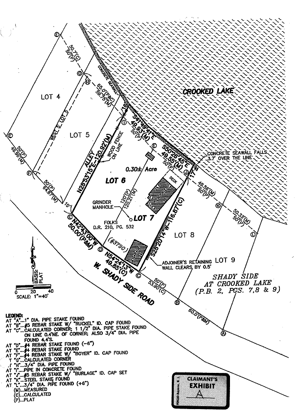
This survey fairly depicts the conditions applicable to the Alley, Lot 6, and Lot 7 in 2007.
[VOLUME 12, PAGE 227]
23. Following the purchase of Lot 6 and Lot 7, Rademaker razed the existing house and built a new house on Lot 7. He then sold Lot 7. Rademaker continues to be the owner of Lot 6. Lot 6 abuts Crooked Lake.
24. The system of law dominant in Great Britain and in the eastern United States, including Indiana, in which owners of lands along a river, stream or lake have the right to reasonable use of the waters, and a correlative right protecting against unreasonable use by others, is riparian doctrine. McCulloch v. Day & Schramm, 12 Caddnar 40, 47 (2009).
25. Property rights associated with rivers and streams were traditionally known as “riparian rights”, while those associated with lakes were traditionally known as “littoral rights”. In Indiana, the single term “riparian rights” is today used to describe the rights of property owners along rivers, streams, and lakes. Parkison v. McCue, 831 N.E.2d 118, 128, Footnote 3 (Ind. App. 2005).
26. “The first, and most basic, right of a riparian owner is access to the water.” 1 Dellapenna, “Introduction to Riparian Rights”, Waters and Water Rights §6.01(a)(1) (LexisNexis 2009). A pier or other structure in support of navigation can be a legitimate exercise of riparian rights. Zapffe v. Srbeny, 587 N.E.2d 177 (Ind. App. 1992).
27. A riparian owner along a public freshwater lake typically enjoys rights which include: (1) access to the public water; (2) the placement of a pier to the line of navigability; (3) the use of accretions; and, (4) reasonable use of the water for purposes such as boating and domestic use. Parkison v. McCue at page 128.
28. Within the lateral boundaries of its terrestrial lands, a riparian owner can enjoy private ownership of a pier on a navigable waterway, although the ownership is subject to the navigational servitude of the United States and the public trust of the State. 1 Dellapenna, “Introduction to Riparian Rights”, Waters and Water Rights §6.01(a)(2) (LexisNexis 2009). In Indiana, these principles are also applied to public freshwater lakes. Bath v. Courts, 459 N.E.2d 72 (Ind. App. 1984) and Parkison v. McCue cited previously.
29. Rademaker has riparian rights as a consequence of ownership of Lot 6.
30. Apart from the Alley, the Respondents do not own real estate which is along Crooked Lake. Their lots are separated from Crooked Lake by West Shady Side Road and by lakeside lots (such as Lot 5, Lot 6, and Lot 7). Testimony of Leisa Reese.
31. The status of riparian ownership may be achieved through adverse possession or by prescriptive easement. 1 Dellapenna, “Riparian Rights”, Waters and Water Rights §7.04(c) (LexisNexis 2009).
32. If the Steuben Circuit Court ultimately determines adverse possession favorably to the Respondents (or Shadyside Neighbors Association, LLC) and against Rademaker in No. 76C0-0904-0305, then the Respondents (or Shadyside Neighbors Association, LLC) have riparian rights as a consequence of ownership of the Alley[2]. If the Steuben Circuit Court ultimately rejects the Respondents’ claim of adverse possession, the Respondents do not have rights in Crooked. Lake based upon riparian ownership.
D. Licensure of Group
Piers
33. In 2007 when Rademaker purchased Lot 6 and Lot 7, the Respondents were already maintaining a pier in Crooked Lake which extended from the Alley. This pier is sometimes referred to as the “Respondents’ pier”.
34. For purposes of the Lakes Preservation Act and as applied to this proceeding, a permanent rule defines “group pier” as “a pier that provides docking space for the following:
(1) At least five (5) separate property owners.
….
(4) A condominium, cooperative, or other form of horizontal property….”
312 IAC § 11-2-11.5.
35. Effective January 1, 2009, the DNR Director adopted a temporary rule to provide regulatory standards for “group piers” placed on public freshwater lakes through December 31, 2009. LSA Document #08-933(E) posted in the Indiana Register on December 31, 2008.
36. Effective January 1, 2010, the DNR Director adopted a second temporary rule which provided regulatory standards for “group piers” that, as applicable to this proceeding, were identical to those in LSA Document #08-933(E). LSA Document #09-987(E) posted in the Indiana Register on December 17, 2009. LSA Document #09-987(E) is effective through December 31, 2010.
37. For purposes of LSA
Document #08-933(E) and LSA Document #09-987(E) as applied to this proceeding,
a “group pier” refers to “a pier that provides docking space for any of the following:
(1) At least five
(5) separate property owners.
….
(4) A condominium,
cooperative, or other form of horizontal property….”
38. As configured in 2007, the Respondents’ pier served at least five separate property owners. As a temporary structure, the Respondents’ pier is typically removed during winter months but was not removed in the winter of 2009-2010. During the boating season, at least five separate property owners used the Respondents’ pier through 2009. Testimony of Keith Reese.
[VOLUME 12, PAGE 228]
39. Since at least 2007, the Respondents’ pier was a “group pier” under subdivision (1) of the definitions set forth in each of 312 IAC § 11-2-11.5, LSA Document #08-933(E), and LSA Document #09-987(E). The Respondents’ pier provided docking space for at least five separate owners. With ownership claims of other Respondents being transferred to Shadyside Neighbors Association, LLC, the Respondents’ pier may now additionally qualify as a “group” pier under subdivision (4).
40. First Sergeant William Snyder is employed by DNR’s Division of Law Enforcement. He is an Indiana Conservation Officer with 36 years of experience and is presently the Assistant Manager of District 2 with its main offices located in Columbia City. As such, he is familiar with the permitting of group piers. First Sgt. Snyder testified he did not believe a permit application had been submitted to the DNR for the Respondents’ pier as a group pier.
41. The testimony of other witnesses was consistent with First Sgt. Snyder’s belief. The Respondents have not applied to the DNR for a permit to maintain a “group pier” on Crooked Lake. Testimony of Keith Reese and Testimony of Leisa Reese.
42. Temporary rules and permanent rules typically have only prospective application. A structure lawfully placed within a public freshwater lake before the effective date of a new statute or rule can be maintained as a lawful nonconforming use. These general statements of law were applied specifically to LSA Document #08-933(E) in Rekeweg v. Nix, 12 Caddnar 75, 81 (2009).
43. The Respondents were not required to obtain a license under the Lakes Preservation Act for a “group pier” if the Respondents’ pier qualifies for maintenance as a “lawful nonconforming use”.
E. Application of Lawful
Nonconforming Use
44. For the Lakes Preservation Act, lawful nonconforming uses are addressed at 312 IAC § 11-5-2. Section 2 provides in pertinent parts:
Sec. 2. (a) A structure or facility that was lawfully placed before the effective date of a provision of:
(1) IC 14-26-2; or
(2) a section of:
(A) 312 IAC 11-3;
(B) 312 IAC 11-4; or
(C) this rule;
including a structure or facility lawfully placed under a section of 310 IAC 6-2 before its repeal, which would be unlawful if placed after that date, is eligible for qualification under this section as a lawful nonconforming use.
(b) This subsection governs the establishment of a lawful nonconforming use as follows:
(1) A person who claims a lawful nonconforming use has the burden of proof for establishing:
(A) the existence of the use; and
(B) that the use was lawful;
when the new or amended statutory or rule section became effective. Except as provided in subdivision (2), a use must have been in existence when the new or amended section became effective and not merely at some time before it became effective.
(2) If a rule section that governs the placement of a temporary structure becomes effective outside the boating season, but a temporary structure was used during the previous boating season, the use is considered to have been in existence when the section became effective. As used in this subdivision, the boating season is from April 1 through October 31.
….
(4) Except as provided in subdivision (5), a person may deliver a written request and supporting documentation in support of a claim to any lawful nonconforming use that arises under IC 14-26-2 or this article. Except as provided in subdivision (5), a person who does not deliver a request under this subdivision is not prohibited from asserting the benefits of a lawful nonconforming use as an affirmative defense or otherwise in a proceeding under IC 4-21.5.
(5) A person must satisfy this subdivision in order to retain the status of a lawful nonconforming use for a pier that is longer than one hundred fifty (150) feet…. By January 1, 2010[3], the person must deliver, to the department's division of law enforcement at the district headquarters for the district in which the lawful nonconforming use is located, a written request and supporting documentation sufficient to demonstrate the existence of the lawful nonconforming use.
(6) The [DNR] shall provide notice under IC 4-21.5-3-5 of a determination that a structure qualifies or does not qualify as a lawful nonconforming use under subdivision (4) or (5).
(7) The [DNR] shall maintain a public file or files to memorialize any determinations under this subsection. The department may include in the file a determination that a structure qualified or did not qualify as a lawful nonconforming use even if the determination was made before the effective date of this subsection….
45. The general procedural framework for assertion of a lawful nonconforming use is set forth in section 2(b)(4): “…[A] person may deliver a written request and supporting documentation [to the DNR] in support of a claim to any lawful nonconforming use that arises under IC 14-26-2” or 312 IAC § 11. A “person who does not deliver a request under this subdivision is not prohibited from asserting the benefits of a lawful nonconforming use as an affirmative defense or otherwise in” an AOPA proceeding.
[VOLUME 12, PAGE 229]
46. First Sgt. Snyder testified briefly concerning a DNR initiative directed to lawful nonconforming uses and piers longer than 150 feet. In 312 IAC § 11-5-2(b)(5), an exception is provided to the general procedural framework, for asserting of a lawful nonconforming use, with respect to piers longer than 150 feet. For piers longer than 150 feet, a person seeking the benefits of a lawful nonconforming use must make application to the DNR and must make the application by a specified date.
47. A claim of lawful nonconforming use for other than a pier exceeding 150 feet long may be pursued through a written request or may be raised “as an affirmative defense or otherwise”. Also, no deadline is set for action by the person making the claim.
48. Testimony at hearing suggests the length of the Respondents’ pier is approximately 100 feet. No witness testified to a length exceeding 150 feet.
49. First Sgt. Snyder testified he did not believe an application had been submitted for the Respondents’ pier seeking qualification as a lawful nonconforming use. Testimony of other witnesses was consistent with this belief.
50. Because the Respondents’ pier is less than 150 feet long, the Respondents are under no compulsion to file an application in order to preserve the status of lawful nonconforming use as a group pier. The Respondents may file the application at a future date. Alternatively, they may make the claim as an affirmative defense or as otherwise appropriate in an AOPA proceeding.
51. For the Respondents to successfully assert a lawful nonconforming use, they must satisfy a threshold requirement of demonstrating riparian ownership. Whether they have riparian ownership, and, if so, the geographic extent of the ownership, are questions awaiting determination by the Steuben Circuit Court through their adverse possession claim. Absent a successful claim of adverse possession, the Respondents’ use of Crooked Lake for the placement of a group pier is unlawful rather than lawful.
F. Delineation of Riparian
Zones
52. Robert W. Wilkinson has a Bachelor of Science in Land Surveying from Purdue University. He is a member of the Indiana Society of Professional Land Surveyors and a member of the Indiana Geographic Information Council. Wilkinson is employed by the DNR’s Division of Water as the Supervisor of the Surveying and Mapping Section. He has served in this capacity since the summer of 1984. The Surveying and Mapping Section performs field surveys primarily related to the evaluation of water resources. Included among the Section’s duties is to provide recommendations concerning riparian water rights. Wilkinson has made riparian rights recommendations “probably about a dozen times,”[4] and he has previously testified concerning these recommendations.
53. Wilkinson is familiar with “Riparian Zones within Public Freshwater Lakes and Navigable Waters”, Information Bulletin #56 (First Amendment) at www.in.gov/legislative/iac/20081210-IR-312080891NRA.xml.html. This document is sometimes referred to as “Information Bulletin #56”.
54. Based primarily upon decisions rendered by the Court of Appeals of Indiana, the Commission in Bulletin #56 identified four basic principles to assist with delineating boundaries between riparian zones.
First principle: Where persons purchased their properties pursuant to a homeowner association's constitution and bylaws, or a similar document intended to govern their respective riparian rights, the document determines the riparian rights of those persons.
Second principle: Where the shore approximates a straight line, and where the onshore property boundaries are approximately perpendicular to this line, the boundaries of riparian zones are determined by extending the onshore boundaries into the public waters.
Third principle: Where the shore approximates a straight line, and where the onshore boundaries approach the shore at obtuse or acute angles, the boundaries of riparian zones are generally determined by extending a straight line at a perpendicular to the shore. If the boundaries of two owners intersect at the shore, or in proximity to but landward of the shore, the boundaries of the riparian zones may be formed by a perpendicular to the shore from the point of intersection of the onshore boundaries. Application of the third principle is most compelling where land owners in the vicinity have historically used a perpendicular line to divide their riparian zones, but the principle should not be applied where a result is to deprive a riparian owner of reasonable access to public waters.
Fourth principle: Where the shore is irregular, and it is impossible to draw lines at right angles to the shore for a just apportionment, then the lines forming the boundaries between riparian zones should be run to divide the total navigable waterfront in proportion to the length of the shores of each owner taken according to the general trend of the shore. If the navigable waterfront borders a lake that is substantially round, or is a bay that is substantially round except for its connection to the main body of the public waters, the riparian zones may be made by running lines from each owner's shore boundaries to the center of the lake or bay. If the navigable waterfront borders a long lake or other public waters that are not substantially round, the riparian zones may be made by identifying a line through the center of the public waters, with deflected lines run from each owner's shore boundaries to intersect the centerline at perpendiculars.
[VOLUME 12, PAGE 230]
Rekeweg v. Nix, referenced previously, at 78, citing Bath v. Courts, 459 N.E.2d 72 (Ind. App. 1984), Daisy Farm Ltd. Partnership v. Morrolf, 888 N.E.2d 604 (Ind. App. 2008), and Lukis v. Ray, 888 N.E.2d 325 (Ind. App. 2008). These decisions have their roots in a Wisconsin Supreme Court case, Nosek v. Stryker, 103 Wis.2d 633, 309 N.W.2d 868 (Wis. 1981).
55. One of Wilkinson’s responsibilities as the Supervisor of the Surveying and Mapping Section is to provide guidance to the Assistant Director of DNR’s Division of Water regarding the delineation of riparian zones. In providing guidance, he examines the nature of properties involved, the configuration of the shoreline, and the amount of shoreline in order to make a fair and reasonable determination of the riparian rights of adjoining property owners. Wilkinson testified he applied Information Bulletin #56, performed these examinations, and copied a 2008 aerial photograph to develop a map and a memorandum which he then provided to the Assistant Director. Wilkinson’s March 1, 2010 “Memorandum”, with 2008 aerial photo attached (including spatial delineations by Wilkinson), was admitted as DNR Exhibit IV. The attached 2008 aerial photo (including spatial delineations by Wilkinson) is as follows:
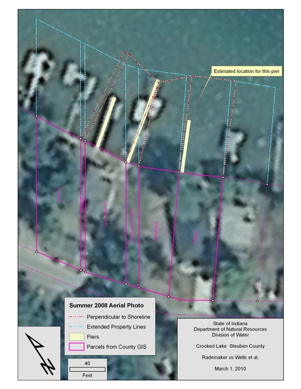
56. On DNR Exhibit IV, blurred images along the shoreline indicate piers and attachments to piers. From northwest to southeast, yellow strips indicate the approximate locations of the pier on Lot 5, the pier on the Alley, and the pier on Lot 7. The pier on Lot 7 was not present at the time of the aerial photograph but was estimated by Wilkinson using surveys and other documentation. The solid pink lines are property lines derived from the Steuben County GIS system. Lot 5 is referenced as the Crothers parcel. The Alley is referenced as the “Homeowners Assoc.” parcel. Lot 6 is referenced as the “Rademaker” parcel. Lot 7 is referenced as the “Dobosz” parcel. The dashed blue-and-white lines are the real estate boundaries extended in a straight-line from the shoreline into Crooked Lake. The dashed red-and-white lines are perpendicular to the shoreline into Crooked Lake from where real estate boundaries intersect the shoreline.
57. Wilkinson did not recommend the extension of property lines, represented by the dashed blue-and-white lines in DNR Exhibit IV, for determining riparian zones. He testified that doing so would have a domino effect for landowners’ riparian zones along the shoreline of Crooked Lake.
58. Instead, Wilkinson testified on direct examination by the Claimant that he used the “Colonial method” to determine the perpendiculars that are designated as dashed red-and-white lines. He recommended in DNR Exhibit IV, and at hearing, the use of the “Colonial method” for the delineation of riparian lines between the Alley and Lot 6. Wilkinson testified, “Basically, I determined that the historical practice appears to be to go perpendicular to the shoreline, so I used the Colonial method…as a means of deciding exactly how to draw the perpendiculars.” This approach was appropriate because the width of access for each riparian owner’s parcel must be considered. The widest riparian zones both for the Alley and for Lot 6 are at their respective shorelines. The amount of space narrows when moving from the shoreline into Crooked Lake. Wilkinson testified, because “it’s on a curve, an irregular curve, the lines would be like radiuses of a true circular curve.” The greatest width for the Alley is 15 feet, and the greatest width for Lot 6 is 50 feet.
59. The “Colonial method” is described in a textbook entitled Boundary Control and Legal Principles that Wilkinson has used since he was a student of land surveying at Purdue University. The method is described beginning on page 311 of the publication:
The method used in Maine to apportion tidelands (alluvial flats) by drawing a base line from one corner of each lot to the other, at the margin of the upland, and running a line from each of these corners, at right angles to the base line to low water will be referred to as the Colonial method….
60. On cross-examination by the DNR, Wilkinson testified regarding implementation of the Colonial method by a land surveyor. “…[A] line has to be perpendicular to another line. Since these are coming off property corner points, the Colonial method basically says if you go to a property corner point, you point to the lot on this side and turn 90 degrees,” then you point to the lot on the opposite side “and turn 90 degrees. You may have a small angle at that point. If you do have an angle at that point, you simply bisect the angle so the line is not necessarily perpendicular to either boundary but bisects the angle of those two right angles…. Another method could simply be to take a protractor and arbitrarily estimate a perpendicular. It’s a documented procedure in that text.”
[VOLUME 12, PAGE 231]
61. On cross-examination by the DNR, Wilkinson also testified the Colonial method is an application of the Third Principle referenced in Information Bulletin #56 as more particularly set forth in Finding 54. “That was my recommendation—that Principle Three applies in this situation.”
62. In the Memorandum for DNR Exhibit IV, Wilkinson stated:
The attached map is based on limited accuracy data. The parcel boundary lines are from the GIS and are not based on an accurate ground survey. The 2008 aerial photography also is not the most accurate, I estimate that it may have an accuracy of plus and minus 5 meters (about 16.4 feet). Exact measurement of the relationship between the piers and the lot corners will require a survey be performed on the ground.
At hearing, Wilkinson testified consistently with the Memorandum. “A surveyor could go out and actually stake the [riparian] zones, you know, physically on the ground” to implement the Colonial method as conceptualized in DNR Exhibit IV.
63. Wilkinson summarized his recommendation for the delineation of riparian zones between the Alley and Lot 6 being the dashed red-and-white line depicted on the aerial photograph in Finding 55 “or something close to it.” On direct examination by the Claimant, he testified this recommendation was consistent with his recommendations in previous riparian zone analyses and consistent with application of the Colonial method. On cross-examination by the DNR, Wilkinson testified that he “believed the riparian zones should be more-or-less perpendicular to the shoreline.”
64. First Sgt. Snyder testified that generally one property owner cannot lawfully encroach on the riparian zone of another property owner. In reviewing an application for a pier permit, the Division of Law Enforcement was primarily concerned with navigation and safety issues. These concerns included “whether or not there is a navigational issue as far as the length of it extending out into high-speed boating or any type of issue that may be adjoining a beach. I look at…the ability of boats to ingress and egress from the shoreline.”
65. Several other witnesses testified concerning how they believed riparian zones should be delineated. For the most part, their testimonies related to historic usages, opinions of third persons not testifying, adverse economic consequences, or obstructions caused by piers and moored boats to lake views. Historic uses may have a bearing upon a claim of adverse possession, but this issue is for resolution by the Steuben Circuit Court. Opinions of third persons are hearsay and generally unpersuasive. The Commission’s subject-matter jurisdiction is derived from the Lakes Preservation Act, and the Lakes Preservation Act does not authorize the Commission to make dispositions based upon adverse economic consequences. Besides, where riparian zones are at issue, adverse economic consequences to one party are likely to be favorable economic consequences to another. Indiana does not recognize “a riparian right to an unobstructed view as a legally protected use…. The scope of a landowner’s view, whether of the water or otherwise, is a policy decision best left to the legislative branch generally and the local zoning authorities specifically….” Center Township Corp. v. City of Mishawaka, 882 N.E.2d 762, 772.
66. Neither the owner of Lot 5 nor the owner of Lot 7 is a party. The parties are the Claimant (the owner of Lot 6), the Respondents (who claim ownership of the Alley), and the DNR (as regulatory authority under the Lakes Preservation Act). The only boundary of a riparian zone which can be delineated in this proceeding is the boundary resulting from the common line between the Alley and Lot 6.
67. Viewing the common boundary between the Alley and Lot 6 in isolation, application of the Second Principle would be functional. The Alley and Lot 6 would accommodate the four basic riparian rights described in Parkison v. McCue: (1) access to public water; (2) an ability to place a pier to the line of navigability; (3) use of accretions; and, (4) reasonable use of the water for purposes such as boating and domestic use.
68. Application of the Third Principle is found preferable to application of the Second Principle. The only expert witness to testify in support of a particular method was Robert Wilkinson, a land surveyor who is trained and experienced in delineating riparian zones. Wilkinson supported the Third Principle. His support was based, in part, upon historic usage in the area. Application of the Third Principle is most compelling where land owners in the vicinity have historically used a perpendicular line to divide their riparian zones. His support was based, in part, on concerns that applying another principle could have a subsequent domino effect and disrupt landowners who are not parties. Although the rights of non-parties are not adjudicated, the Commission is responsible for considering the “cumulative effect”[5] that is the likely consequences of an action. The disruption from the “domino effect”, which is a likely result from application of the Second Principle, is appropriately avoided. The Third Principle accommodates the characteristics of the portion of Crooked Lake under consideration, and the Third Principle appears best designed to provide riparian owners with equitable access to public waters. The Colonial method is appropriate to implementing the Third Principle and determining the boundaries of the riparian zones between the Alley and Lot 6.
G. Setback
Requirements between Riparian Zones
69. The Commission recognized in 2005 that setback requirements between riparian zones might reasonably be required for a dispute among riparian owners concerning the placement of temporary piers. Rekeweg v. Nix, referenced previously, at 79, citing Roberts v. Beachview Properties, LLC, et al., 10 Caddnar 125 (2005), which required a setback of “10 feet for the base of all temporary structures, and watercraft moored to such structures.” Similar setback requirements were subsequently imposed in Havel & Stickelmeyer v. Fisher, 11 Caddnar 110, 119; Rufenbarger, et al. v. Blue, et al., 11 Caddnar 185, 194; and, McCulloch v. Day & Schramm, 12 Caddnar 40, 54.
70. First Sgt. Snyder also testified to knowledge of a five-foot setback for structures from the boundary of a riparian zone, a standard which he said was derived primarily from the public trust doctrine and the protection of public rights within public freshwater lakes.
[VOLUME 12, PAGE 232]
71. As described previously in Finding 35 and effective January 1, 2009, the DNR Director adopted a temporary rule to provide regulatory standards for “group piers”. LSA Document #08-933(E). These standards included setback requirements. Effective January 1, 2010, these requirements are set forth in LSA Document #09-987(E) and provide at SECTION 5(d)(1):
(d) The [DNR] shall condition a license
for a group pier or group piers so the placement, configuration, and
maintenance:
(1) Provide a reasonable buffer zone
between the pier and:
(A) the portion of the lake two
hundred (200) feet from the shoreline or water line; and
(B) the riparian zone of adjacent
property owners to provide for reasonable navigation by the adjacent property
owner and by the public. Except as otherwise provided in this clause, the
department shall require at least five (5) feet of clearance on both sides of a
riparian line (for a total of ten (10) feet). The department may require as
much as ten (10) feet of clearance on both sides of a riparian line (for a
total of twenty (20) feet), if based upon the opinion of a qualified
professional that additional clearance is required for reasonable navigation.
The department may approve an exception to this clause where adjacent riparian
owners use a common pier along their mutual property line, and the purposes of
this clause are satisfied by waters elsewhere within their riparian zones.
72. As with other rules under the Lakes Preservation Act, the setback standards typically have only prospective application. They are requirements for the licensure of new group piers after their effective dates. The setback requirements in LSA Document #08-933(E) had application to a new group pier licensed in 2009. The setback requirements in LSA Document #09-987(E) have application to group piers which are newly placed in 2010.
73. As provided in the decisions referenced in Finding 69, setback requirements could also be implemented on a site-specific basis where needed to effectuate the purposes of the Lakes Preservation Act. These purposes include the public trust and public safety. This implementation is based on statutory principles, however, and not particular pronouncements of a rule. There was no regulatory requirement, which set forth a specific setback distance from a riparian line, for a group pier placed in a public freshwater lake before January 1, 2009.
74. The Respondents’ pier has been placed seasonally in Crooked Lake at the extension of the Alley from at least 2007. LSA Document #08-933(E) and LSA Document #09-987(E) do not apply.
75. If the Steuben Circuit Court determines questions of adverse possession favorably to the Respondents in Cause No. 76C0-0904-0305, the Lakes Preservation Act may warrant setback requirements from the line dividing the riparian zones of the Alley and Lot 6. The evidence at hearing did not consider, and probably realistically could not have considered, site-specific conditions bearing upon the interrelationship of a pier from the Alley and a pier from Lot 6. There currently is no pier from Lot 6. Consideration of setbacks based upon the Lakes Preservation Act is now premature.