[CITE: Spaw v. Ashley, 12 CADDNAR 233 (2010)]
[VOLUME 12, PAGE 233]
Cause #: 09-070W
Caption: Spaw v. Ashley
Administrative Law
Judge: Lucas
Attorneys: Kuchmay (Several Claimants); Martin (Several Respondents
Block 6); Niezer (Several Respondents Block 7 &
8); Wyndham (DNR); pro se (several Claimants/Respondents)
Date: July 28, 2010
[NOTE: ON AUGUST 27, 2010, THE RESPONDENTS FILED PETITION FOR JUDICIAL REVIEW WITH THE ALLEN
CIRCUIT COURT IN CAUSE NO. 02C01-1008-MI-001178. ON JULY 8, 2011, ALLEN CIRCUIT COURT
ENTERED ORDER UPHOLDING ADMINISTRATIVE DECISION. ASHLEY FILED APPEAL (02A03-1108-MI-00340). ON APRIL 17, 2012,
THE COURT OF APPEALS ENTERED ITS MEMORANDUM DECISION (NFP).]
FINAL ORDER
Paragraph (1) Each Lot owner in Block 6, Block 7, and Block 8 has a
geographically unique easement on the shoreline or water line of Big Long Lake
that is six feet wide. Subject to the
regulatory authority of the Department of Natural Resources under IC 14-26-2
and 312 IAC 11-1 through 312 IAC 11-5, the easement may be used for a boat
landing, including the placement of a temporary pier. The easement is in front of the Block in
which the Lot is located. Each
individual easement shall bear the same number as the Lot it is for and shall
be numbered consecutively from north to south.
Paragraph (2) The boundaries of the riparian
zones for Lot 51 through Lot 64 shall be delineated as set forth in Finding 94
through Finding 98.
Paragraph (3) The boundaries of the riparian
zones for Lot 65 through Lot 97 shall be delineated as set forth in Finding 102
through 109.
Paragraph (4) A land surveyor, registered under IC 25-21.5, must perform a survey under IC 25-21.5 and 865 IAC 1 to document and memorialize the boundaries of any easement and associated riparian zone, as described in Paragraph (1) through Paragraph (3), before a person may use the easement or place a structure in the associated riparian zone. In performing the survey, the land surveyor shall consult with the DNR’s Division of Water.
Paragraph (5) The Department of Natural Resources may apply 312 IAC 11-3-4 as appropriate to accomplishing the purposes of this Final Order.
Paragraph (6) No pier, boat station, platform, or similar structure shall be placed along Block 6, Block 7, or Block 8 that is inconsistent with this Final Order. A pier, boat station, platform, or similar structure which does not conform to this Final Order is unlawful. This Final Order does not govern the placement of seawalls or the placement of structures landward of the shoreline or water line of Big Long Lake.
Paragraph (7) The motion for stay based on the Stucks’ bankruptcy petition is denied.
Paragraph (8) The
effectiveness of Paragraph (1) through Paragraph (6) of this Final Order is
deferred until January 1, 2011.
FINDINGS OF FACT AND
CONCLUSIONS OF LAW
A. Statement of the Case and Jurisdiction
1. On April 13, 2009, Jeffrey Spaw and Holley Spaw (the “Spaws”), pro se, requested relief from the Natural
Resources Commission (the “Commission”) with respect to a riparian rights dispute
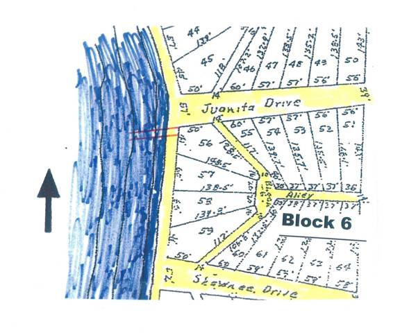
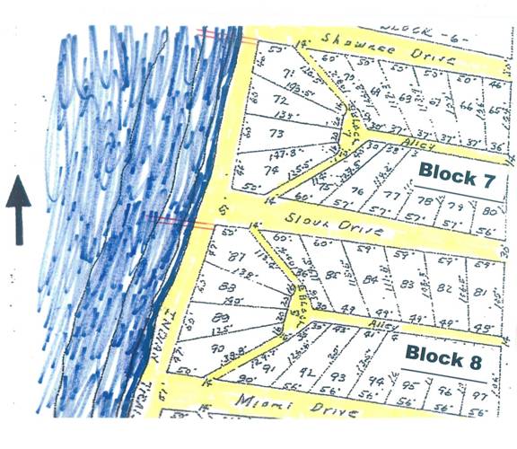
along a portion of Big Long Lake in LaGrange County.
2. On April 14, the Commission’s
Division of Hearings sent a reply to the Spaws in
which they were requested to provide a narrative and greater specificity
concerning the relief sought. On the
same day, the Spaws responded with correspondence
that indicated the dispute primarily involved the usage of the shore of Big
Long Lake along Block 7 and Block 8 of Long Lake Park, and they referenced
restrictions on the plat of Long Lake Park that were recorded in 1923.
3. On April 15, the Commission
assigned Stephen L. Lucas as its administrative law judge for a proceeding governed
by Ind. Code § 4-21.5 (sometimes referred to as the “Administrative Orders and
Procedures Act” or “AOPA”) and rules adopted at 312 Ind. Admin. Code § 3-1 to assist with the implementation of AOPA. A “Notice of Initial Prehearing Conference”
was served upon the Spaws and persons identified by
the Spaws as potentially interested. The initial prehearing conference was
scheduled for May 8 in Columbia City, Indiana.
4. On May 5, Michael M. Ashley and
others by their attorneys, Thomas M. Niezer, Patrick
G. Murphy, and Michael H. Michmerhuizen (collectively
“Barrett & McNagny, LLP”), filed a “Motion to Intervene” as respondents.
5. On May 7, Jason M. Kuchmay, James A. Federoff, and
Scott M. Federoff filed their appearances (collectively
“Federoff Kuchmay LLP”) for
the Spaws and others as claimants.
6. The initial prehearing
conference was conducted as scheduled on May 8, 2009. In addition to Block 7 and Block 8, some of the
parties stated Block 6 was in issue. The
“Motion to Intervene” referenced in Finding 4 was granted without
objection. The claimants by their
attorneys indicated they would move to join additional parties. Without objection, the Department of Natural
Resources (the “DNR”) was added as a third party respondent. Other preliminary matters were considered,
including discovery, mediation, and the scheduling of a stay hearing and final
hearing.
[VOLUME 12, PAGE 234]
7. On May 11, a “Motion (i) to Intervene, (ii) to Designate Proper Parties as
Claimants, and (iii) to Provide Notice to Indispensable Parties” was filed on
behalf of several of the claimants. The
motion was granted without objection on May 21.
8. The “parties” as captioned include
each of the claimants, each of the respondents, and the DNR. Several reconfigurations of status as a
claimant or a respondent have been made since the “Notice of Initial Prehearing
Conference”, all without objection by the other parties. These reconfigurations are incorporated in
the caption. On December 18, 2009, the
parties confirmed that, to the best of their knowledge, each person who owns a
lot in Block 6, Block 7, or Block 8 of Long Lake Park has been served and made
a party. “Entry
Following Hearing on Summary Judgment” (December 22, 2009).
9. Big Long Lake in LaGrange
County is a “public freshwater lake” for purposes of IC 14-26-2 (sometimes
referred to as the “Lakes Preservation Act”) and rules adopted at 312 IAC 11-1
through 312 IAC 11-5 to assist with implementation of the Lakes Preservation
Act. “Report of Prehearing Conference
for Stay Hearing” (May 28, 2009).
10. The waters of Big Long Lake
within its “shoreline or water line”, as the phrase is used in IC 14-26-2-4,
are public waters and subject to the Lakes Preservation Act.
11. The Indiana Department of
Conservation (predecessor to the DNR) filed a “Report and Petition to Establish
Average Normal Water Level” with the LaGrange Circuit Court on June 24, 1964 in
Cause No. 2476. In response to the
petition and following a completed action, the LaGrange Circuit Court
determined by “Order” on July 22, 1965 that the legal elevation of Big Long
Lake was 956.21 feet, mean sea level. None
of the parties has provided evidence to support a modification of the “Order”
of the LaGrange Circuit Court. The legal
elevation of Big Long Lake is 956.21 feet, mean sea level. “Orders Regarding Legal Elevation of Big Long
Lake and Regarding Motion to Withdraw Appearance on Behalf of Jennifer H.
Miller and Zachary A. Miller” (September 16, 2009).
12. The “shoreline or water line” of Big Long
Lake is established by IC 14-26-2-4(1) at 956.21 feet, mean sea level. “Orders Regarding Legal Elevation of Big Long
Lake and Regarding Motion to Withdraw Appearance on Behalf of Jennifer H. Miller
and Zachary A. Miller” (September 16, 2009).
13. On the public waters of Big
Long Lake, a trust exists for which the State of Indiana is the trustee. The DNR is the state agency primarily
responsible for administering the trust.
The Lakes Preservation Act places the full power of public freshwater
lakes in the State of Indiana to hold in trust for all Indiana citizens to
preserve natural scenic beauty and for recreational purposes. Indiana Dept. of Nat. Res. v. Lake George, 889 N.E.2d 361 (Ind.
App. 2008) and Lake of the Woods v.
Ralston, 748 N.E.2d 396, 401 (Ind. App. 2001).
14. The Commission is the “ultimate authority” for agency determinations under the Lakes Preservation Act and 312 IAC 11-1 through 312 IAC 11-5, including those derived from competing interests among persons claiming riparian rights or interests in riparian rights that may be sufficient for the placement of piers and similar structures in public freshwater lakes. IC 14-10-2-4 and IC 14-26-2-23. Lukis v. Ray, 888 N.E.2d 325 (Ind. App. 2008), transfer denied, cited in Rekeweg v. Nix, 12 Caddnar 75 (2009)[1].
15. Prior to the commencement of
this proceeding as described in Finding 1, a civil action was commenced in the
LaGrange Circuit Court in which some of the respondents to this proceeding asserted
a claim of adverse possession to real estate located along the shoreline or
water line of Big Long Lake and adjacent to Block 6, Block 7, and Block 8. The civil action in the LaGrange Circuit
Court is pending. On December 18, the
parties stipulated that the LaGrange Circuit Court has exclusive jurisdiction
and the Commission lacks jurisdiction to consider the claim of adverse
possession. “Entry
Following Hearing on Summary Judgment” (December 22, 2009).
16. With the exception of the
claim of adverse possession referenced in Finding 15, the Commission has
jurisdiction over the persons and over the subject matter of this proceeding.
B. LaGrange County Ordinance
17. The “Report of Prehearing Conference for Stay Hearing” entered on May 28, 2009 included discussion of the relevance of a LaGrange County ordinance. As set forth in the Report:
The parties discussed the existence of a Lagrange County Ordinance which the Respondents represented by Barrett & McNagny, LLP contend bears upon a disposition of this proceeding by the Natural Resources Commission. The Claimants represented by the Federoff Law Firm dispute the relevance of the ordinance. The parties were invited but not ordered to brief this issue.
[VOLUME 12, PAGE 235]
18. On June 5, 2009, the “Claimants’ Memorandum Regarding Inapplicability of the LaGrange County Zoning Ordinance and the Godlewski Decision to These Proceedings” (the “Claimants’ Ordinance Brief”) and the “Respondents’ Brief Regarding Applicability to Local Ordinance” (the “Respondents’ Ordinance Brief”) were timely filed.
19. The parties indicated the document which precipitated discussion of the LaGrange County Ordinance was a letter issued by Chris Godleweski, LaGrange County Planning Administrator, on May 5, 2009. The letter stated in substantive part:
This letter is in response for the request of my decision as Zoning Administrator for the LaGrange County Plan Commission. This matter is specific to boat docks classified as accessory uses. The zoning ordinance, which was put into effect November 17, 2005, is the governing document for the land use in Hartzell’s addition.
Your request was specific to Block 7 and Block 8 of Hartzell’s Addition. In addition to your specific request, the accessory use for boat docks applies to all accessory uses created after the 2005 ordinance. The accessory use regulation has to apply to all new situations after the adoption of the ordinance.
My findings are as follows with regard to accessory use of a boat dock. Under Article 3(K)(2)(a) & (b) the general requirements determine that accessory use should be incidental and subordinate to the primary use of the lot (paraphrased). The accessory use shall be operated and maintained under the same ownership or control (paraphrased).
These findings specified under Article 3 (K) state that these uses shall be operated and maintained by the owner with the primary use of the lot. This is a situation where Indian Trail is not owned by any one single owner. A boat dock could not be operated as an accessory use because it is not maintained or under the ownership of a primary use on a lot.
To your client’s request, it is my determination that all residents in Hartzell’s Addition in Block 7 & 8 do not have permitted boat docks as accessory uses. The presence of Indian Trail, which is between owned parcels of ground and the water’s edge, would hamper the ability to own or maintain a boat dock on the same lot as the owner. Therefore each individual maintaining a boat dock on Indian Trail would not be in compliance with the LaGrange County Ordinance.
Respondents’ Brief, Exhibit A.
20. On June 4, 2009, the claimants sought review from the LaGrange County Board of Zoning Appeals of the May 5 determination by the LaGrange County Planning Administrator. Claimants Ordinance Brief, Exhibit B.
21. The Commission has held consistently that it has jurisdiction concerning the placement of piers and similar structures within the shoreline or water line of a public freshwater lake, but jurisdiction regarding the management of land use outside the shoreline is the province of local government. Illustrative is Pipp v. Spitler, et al., 11 Caddnar 39 (2007). The Commission there determined the Board of Commissioners of Kosciusko County had jurisdiction over a roadway which terminated at the shoreline of Lake Wawasee, a public freshwater lake. The Commission found that extending into the lake from the roadway was a navigational channel, and the parties to the adjudication could not unreasonably impede boating through the channel. The Board of Commissioners was unfettered in its management of the roadway and could cause its vacation, even though the consequence would be to negate the utility of the navigation channel.
22. Similarly, the Commission has no legal interest in regulation by LaGrange County of land use which is landward of the shoreline or waterline of Big Long Lake. The claimants contend the effect of the May 5 determination by the LaGrange County Planning Administrator would “undermine the law of easements” and result in “an improper taking” of property rights. Even if those contentions are established, they have no legal consequence to the Commission. Consistently with actions taken by the claimants, their remedy is through the LaGrange County Board of Zoning Appeals and not the Commission.
[VOLUME 12, PAGE 236]
23. A county has broad authority to establish ordinances to govern the affairs of its citizens under IC 36-1-3, a statutory chapter commonly referred to as the “Home Rule Act”. The Indiana General Assembly has specifically withheld the authority for a few items at IC 36-1-3-8. An item for which the power to adopt an ordinance is withheld is set forth in IC 36-1-3-8(a)(7): “The power to regulate conduct that is regulated by a state agency, except as expressly granted by statute.”
24. In IC 14-26-2-23, the Lakes Preservation Act directs the DNR and the Commission to regulate the placement of piers within a “public freshwater lake”. In implementing the authority, these state agencies must consider the “interests of a landowner having property rights abutting the public freshwater lake or rights to access the public freshwater lake.” IC 14-26-2-23(c)(5). Rules adopted by the Commission at 312 IAC 11-1 through 312 IAC 11-5 assist with this process.
25. The respondents urged on page 2 of their brief:
The Home Rule Act stands for the proposition that a home rule county cannot prevent a state agency from carrying out actions that are statutorily authorized. Indiana Department of Natural Resources v. Newton County, 802 N.E.2d 430, 433 (Ind. 2004). An ordinance impermissibly conflicts with state law and is in violation of the Home Rule Act if the ordinance seeks to prohibit that which a statute expressly permits. Id. At 433; see also Uhl v. Liter’s Quarry of Indiana, Inc. 384 N.E.2d 1099, 1102 (Ind. Ct. App. 1979). A local governmental unit may supplement burdens imposed by state law if the additional obligations are consistent with the statutory purpose. Board of Public Safety v. State ex rel. Benkovich, 388 N.E.2d 582, 585 (Ind. Ct. App. 1979).[2]
26. Whether the LaGrange County ordinance (or, more directly, whether the interpretation of the ordinance by the LaGrange County Planning Administrator) violates the Home Rule Act is an issue the claimants took to the LaGrange County Board of Zoning Appeals. LaGrange County is not a party here, and issues derived from the propriety of LaGrange County’s exercise of the Home Rule Act are not before the Commission.
27. The Commission applies the Lakes Preservation Act and rules adopted under the Lakes Preservation Act. If the LaGrange County ordinance imposes requirements which supplement burdens imposed by these state laws, the burdens may be lawful or they may be unlawful under the Home Rule Act. In either event, the ordinance is not a law over which the Commission has jurisdiction.
28. The LaGrange County ordinance and the May 5, 2009 interpretation of the ordinance by the LaGrange County Planning Administrator are irrelevant to the Commission’s implementation of jurisdiction under the Lakes Preservation Act.
C. Standards for Summary Judgment
29. Many of the parties participated in filing motions and responses to motions for summary judgment which resulted in the administrative law judge’s entry of an “Interlocutory Order of Partial Summary Judgment” on January 22, 2010. The substance of the interlocutory order is incorporated and approved as set forth below.
30. IC 4-21.5-3-23 governs summary judgment under AOPA and provides:
(a) A party may, at any time after a matter is assigned to an administrative law judge, move for a summary judgment in the party’s favor as to all or any part of the issues in a proceeding. The motion must be supported with affidavits or other evidence permitted under this section and set forth specific facts showing that there is not a genuine issue in dispute.
(b) The motion must be served at least five (5) days before the time fixed for the hearing on the motion. The adverse party may serve opposing affidavits before the day of hearing. The administrative law judge may direct the parties to give oral argument on the motion. The judgment sought shall be rendered immediately if the pleadings, depositions, answers to interrogatories, and admissions on file, together with the affidavits and testimony, if any, show that a genuine issue as to any material fact does not exist and that the moving party is entitled to a judgment as a matter of law. A summary judgment may be rendered upon fewer than all the issues or claims (such as the issue of penalties alone) although there is a genuine issue as to damages or liability, as the case may be. A summary judgment upon fewer than all the issues involved in a proceeding or with respect to fewer than all the claims or parties is not a final order. The administrative law judge shall designate the issues or claims upon which the judge finds no genuine issue as to any material facts. Summary judgment may not be granted as a matter of course because the opposing party fails to offer opposing affidavits or evidence, but the administrative law judge shall make a determination from the affidavits and testimony offered upon the matters placed in issue by the pleadings or the evidence. If it appears from the affidavits of a party opposing the motion that the party cannot for reasons stated present by affidavit facts essential to justify the party’s opposition, the administrative law judge may make any order that is just.
[VOLUME 12, PAGE 237]
(c) If on motion under this section no
order is rendered upon the whole case or for all the relief asked and a hearing
is necessary, the administrative law judge at the hearing of the motion, by
examining the pleadings and the evidence before it and by interrogating any
person, shall if practicable ascertain:
(1) what material facts exist without substantial controversy; and
(2) what material facts are actually and in good faith controverted.
The administrative law judge shall then make an order specifying the facts that
appear without substantial controversy, including the extent to which the
amount of damages or other relief is not in controversy, and directing further
proceedings in the action as are just. Upon the hearing of the action, the
facts specified are established in the judge’s order under this subsection.
(d) Supporting and opposing affidavits
must:
(1) be made on personal knowledge;
(2) set forth facts that are admissible in evidence; and
(3) show affirmatively that the affiant is competent to testify to the matters
stated in the affidavit.
(e) The administrative law judge may permit affidavits to be supplemented or opposed by depositions, answers to interrogatories, further affidavits, or testimony of witnesses.
(f) If a motion for summary judgment is made and supported under this section, an adverse party may not rely upon the mere allegations or denials made in the adverse party’s pleadings as a response to the motion. The adverse party shall respond to the motion with affidavits or other evidence permitted under this section and set forth specific facts showing that there is a genuine issue in dispute. If the adverse party does not respond as required by this subsection, the administrative law judge may enter summary judgment against the adverse party.
31. As provided in 312 IAC 3-1-10, an administrative law judge may apply the Trial Rules where not inconsistent with AOPA. Reference may be made to Trial Rule 56 and to reported decisions based upon Trial Rule 56. If Trial Rule 56 is inconsistent with IC 4-21.5-3-23, the latter controls. Roebel, et al. v. Vorndran, et al., 11 Caddnar 250, 253 (2008).
32. “It is a gratuitous cruelty to parties and their witnesses to put them through the emotional ordeal of a trial when the outcome is foreordained” and in such cases summary judgment is appropriate. Mason v. Continental Illinois Nat’l Bank, 704 N.E.2d 361, 367 (7th Cir. 1983). “The purpose of summary judgment is to terminate litigation about which there can be no factual dispute and which may be determined as a matter of law.” Wells v. Hickman, 657 N.E.2d 172, 175 (Ind. App. 1995).
33. Summary judgment should be granted if the evidentiary material shows there is no genuine issue of material fact, and the moving party is entitled to judgment as a matter of law. Auto-Owners Insurance Co. v. United Farm Bureau Insurance Co., 560 N.E.2d 459 (Ind. App. 1990).
34. “A fact is ‘material’ for summary judgment purposes if it helps to prove or disprove an essential element of the plaintiff’s cause of action.” Graham v. Vasil Management Co., Inc. 618 N.E.2d 1349 (Ind. App. 1993). “A factual issue is ‘genuine’ for purposes of summary judgment if the trier of fact is required to resolve an opposing party’s different versions of the underlying facts.” York v. Union Carbide Corp., 586 N.E.2d 861 (Ind. App. 1992).
D. Pleadings, Documents, and Hearing on Motions for Summary
Judgments
35. On July 28, 2009, a “Report of Telephone Status Conference with Related Entries” ordered a schedule for the performance of filings pertaining to motions for summary judgment. In a “Supplementation to Report of Telephone Status Conference” entered on August 3, 2009, the DNR was placed on the same schedule as was set for the respondents in the July 28 report.
36. On October 26, 2009, the “Respondents’ Motion for Extension of Time to Respond and File Counter-Claim” was filed by Patricia L. Martin on behalf of the respondents she represents. The next day the “Respondents’ Motion for Enlargement of Time to Respond to Claimants’ Motion for Summary Judgment and Enlargement of Time to File Cross-Motions for Summary Judgment” was filed on behalf of the respondents represented by Barrett & McNagny, LLP. On October 29, the “Claimants’ Objection to Respondents’ Motion for Enlargement of Time” was filed on behalf of the claimants represented by the Federoff Kuchmay LLP. Sarah Burtch and Ryan Burtch (the “Burtches”) filed objections to the requests for extension of time on October 30. On October 29, the administrative law judge entered “Orders with Respect to Motions for Extension of Time to Respond to Claimants’ Motion for Summary Judgment” which granted, in part, the requests by Patricia Martin and by Barrett & McNagny, LLP.
[VOLUME 12, PAGE 238]
37. Within the schedules set on July 28, supplemented on August 3, and for which extensions were granted on October 29, 2009, the following parties or their attorneys made timely filings with respect to motions for summary judgments:
(1) Scott L. Ensley, pro se
(2) Burtches, pro se
(3) Paul Zawadzke and Mary Zawadzke, pro se
(4) Zachary Miller and Jennifer Miller, pro se
(5) Federoff Law Firm, LLP on behalf of claimants for which they entered an appearance
(6) Barret & McNagny, LLP on behalf of respondents for which they entered an appearance
(7) Patricia L. Martin on behalf of respondents for which she entered an appearance
38. A hearing on the motions for summary judgment was conducted in Columbia City, Indiana as anticipated by IC 4-21.5-3-23(c) on December 18, 2009. An opportunity was provided to each of the participants, as well as to the DNR, to present oral argument concerning the motions. The opportunity was exercised by all except Scott Ensley and the Burtches.
E. Facts Determined
by Summary Judgment to be Not in Material Dispute
39. Based on the pleadings, documents, and the hearing with respect to the motions for summary judgment, specific facts were found not to be in material dispute. These are set forth in Finding 40 through Finding 51.
40. Lee J. Hartzell
(“Hartzell”) was a riparian owner along Big Long Lake
in LaGrange County, Indiana. On June 12,
1923, Hartzell caused recordation with the LaGrange
County Recorder of a plat for Long Lake Park in the
East One-Half of Section 22, Township 36 North, Range 11 East, Milford Township,
LaGrange County, which included the following
description:
Commencing at
the Northeast Corner of Section Twenty Two (22), Township and Range aforesaid;
thence South on the East line of Said Section 20.14 chains to the center of the
highway; thence North 65 degrees West along the center line of the highway
24.38 chains to a stone corner at the Northwest corner of the Hartzell Farm and which corner was established by John
Rhodes, County Surveyor, by survey made in September, 1856, and the point
marked “A” on the plat is 725 feet South along the
established line fence from this corner.
From the
point marked “A” the plat runs South 47 degrees and 46 minutes East 246 feet;
thence South 78 degrees and 10 minutes East 144 feet; thence South 62 degrees
East 237 feet; thence South 54 degrees and 20 minutes East 168 feet; thence
South 2 degrees West 1779 feet to the North point of Block 12; thence North 45
degrees East 56 feet; thence South 42 degrees and 20 minutes East 439 feet;
thence south 55.5 feet; thence South 30 degrees West 71 feet; thence East 30
feet to the Southwest corner of Lot Number 143; thence North 40 degrees East
along the West line of Lot 143 101.3 feet to the Northwest corner of said lot; thence North 85 degrees and 45 minutes East 303
feet to the East line of the Hartzell Farm; thence
West along said South line of said farm 470 feet to the margin of Long Lake;
thence in a Westerly and Northwesterly direction along the margin of the Lake
3370 feet to the West line of the Hartzell Farm;
thence North along the said West line 120 feet to the place of beginning and
containing Thirty Two Acres, more or less, except Woodland Terrace, numbered 34
which tract of land is not a part of this plat and must in no wise be
considered as a part of the Long Lake Park Plat. The location, numbers and dimensions of the
lots, alleys and streets, are as indicated on the plat.
Plat Book 1, page 118, attached as
Exhibit “A” to Affidavit of Sharon Shiltz, LaGrange
County Recorder (September 23, 2009) and included with “Claimants’ Motion for
Summary Judgment” (Filed September 25, 2009).
41. With the plat for Long Lake
Park described in Finding 40, Hartzell also provided
“Each lot owner shall be entitled to an easement on the Lake Shore six feet in
width for a boat landing which easement shall be in front of the block in which
the lot is located and the easement shall bear the same number as the lot it is
for and the easements shall be numbered consecutively from North to
South.” Plat Book 1, page 118, attached
as Exhibit “A” to Affidavit of Sharon Shiltz,
LaGrange County Recorder (September 23, 2009) and included with “Claimants’
Motion for Summary Judgment” (Filed September 25, 2009). “Entry Following Hearing on
Summary Judgment” (December 22, 2009).
42. As recorded by Hartzell, the plat for Long Lake Park consisted of Block 1
through Block 14 and contained Lot 1 through Lot 157. At issue in this proceeding are Block 6
(containing Lot 51 through Lot 64); Block 7 (containing Lot 65 through Lot 80);
and Block 8 (containing Lot 81 through Lot 97).
As recorded by Hartzell, Block 6 was bordered
on the north by Juanita Drive and on the south by Shawnee Drive. Block 7 was bordered on the north by Shawnee
Drive and on the south by Sioux Drive.
Block 8 was bordered on the north by Sioux Drive and on the south by
Miami Drive. Block 6, Block 7, and Block
8 were each bordered on the west by Indian Trail and on the east by a private drive. Plat Book 1, page 118A and page 118B,
attached as Exhibit “A” to Affidavit of Sharon Shiltz,
LaGrange County Recorder (September 23, 2009) and included with “Claimants’
Motion for Summary Judgment” (Filed September 25, 2009).
[VOLUME 12, PAGE 239]
43. When he recorded the plat described
in Finding 40, Hartzell placed restrictions on the
grants. As may be material or genuine to
this proceeding, the restrictions provided in fact:
1. That all
drives, alleys, and walks are for the use of the owners of lots and their
guests….
2. That none
of said lots…shall be used for a Hotel, Boarding or Lodging House, or Store and
for any commercial purpose with the exception of the renting of cottages for
families and persons who reside therein.… That no boat house
shall be erected upon the lake front.
…
4. That
should any one violate the above limitations than all interest of said grantee,
his heirs or assigns shall at once revert to said grantor [Hartzell]
and he may re-enter, recover, own and control said premises free from any
claims of said grantee, his heirs or assigns, but this limitation shall not effect the interest of any person holding a lien on said
premises except for the violation thereof after such lien should ripen into a
possessory title.
Plat Book 1, page 118, attached as
Exhibit “A” to Affidavit of Sharon Shiltz, LaGrange
County Recorder (September 23, 2009) and included with “Claimants’ Motion for
Summary Judgment” (Filed September 25, 2009).
44. Hartzell
reserved rights in the grant, and no transfer of his servient
estate has been recorded with the LaGrange County Recorder. “Entry Following Hearing on
Summary Judgment” (December 22, 2009).
45. The “Last Will and Testament
of Lee J. Hartzell” was executed in Allen County,
Indiana on July 28, 1955 and was admitted to probate in Allen Superior Court on
September 7, 1955. Hartzell
did not specifically dispose of his interest in Long Lake Park but provided
generally that “All the rest and residue of my estate not heretofore
specifically disposed of, I give, grant and bequeath unto the Indiana Masonic
Home, Franklin Indiana….” “Entry
Following Hearing on Summary Judgment” (December 22, 2009) and anticipated
supplemental information received from Thomas M. Niezer
in email (December 22, 2009). In an
“Entry Regarding Hartzell Will, Deppe
Correspondence, and Deferral to Act upon Motions for Summary Judgment” (January
11, 2010), the parties were provided until January 18, 2010 to object to admission
of the will into evidence. No party objected,
and the will was admitted.
46. During the December 22 summary
judgment hearing, Thomas Niezer said his research
identified Brian J. Deppe of Franklin, Indiana as the
current attorney for the Indiana Masonic Home.
On December 23, 2009, the administrative law judge wrote to Brian J. Deppe to determine what interest the Indiana Masonic Home
might claim as the servient estate for Long Lake Park.
47. On January 6, 2010, Deppe wrote as follows:
This letter
is in response to your letter of December 23, 2009, and I am replying on behalf
of the Indiana Masonic Home. The Indiana
Masonic Home is not claiming interest in Long Lake Park as successor to Lee J. Hartzell.
48. In an “Entry Regarding Hartzell Will, Deppe
Correspondence, and Deferral to Act upon Motions for Summary Judgment” (January
11, 2010), the parties were provided until January 18, 2010 to object to the
admission of Deppe’s correspondence into evidence. No party objected, and the letter was
admitted.
49. Indian Trail has not been
eliminated by erosion, excavation, submersion, or another physical event
associated with principles of riparian ownership. None of the Lots in Block 6, Block 7, or
Block 8 has been caused to abut the shoreline or water line as a result of a
physical event. At least a portion of
Indian Trail exists between the shoreline or water line of Big Long Lake and
the entire lengths of Block 6, Block 7, and Block 8.[3] The statements contained in this Finding are
not relevant to the Commission’s consideration of a claim of abandonment of
easement or consideration of a claim of laches. “Entry Following Hearing on
Summary Judgment” (December 22, 2009).
50. Although the parties dispute
the objective and subjective intents of themselves and their neighbors, the
current and past owners of lots in Block 6, Block 7, and Block 8 have commonly placed
piers in Big Long Lake adjacent to Indian Trail.
51. As described in Finding 43,
“all drives, alleys, and walks are for the use of the owners of lots and their
guests.” In contrast with the easements
described in Finding 41, which are located adjacent to a particular block and
unique to the owners of particular lots, the easements or rights-of-way formed
by Indian Trail, Juanita Drive, Shawnee Drive, Sioux Drive, Miami Drive, and
the alleys are shared by all owners of lots in Long Lake Park.
[VOLUME 12, PAGE 240]
52. With the correspondence
referenced in Finding 47, the successor in interest to Hartzell
relinquished any claim to relief based on the plat referenced in Finding 40.
53. The parties agreed the Commission
has jurisdiction and should properly make a final agency determination
concerning the claims of abandonment of easement and the claims of laches raised by some of the respondents.
F. Riparian Rights and the Easements for Boat Landings
54. The system of law dominant in Great Britain and in the eastern United States, including Indiana, in which owners of lands along a river, stream or lake have the right to reasonable use of the waters, and a correlative right protecting against unreasonable use by others, is riparian doctrine. Baughn v. Town of Culver and DNR, 11 Caddnar 261, 264 (2008).
55. Property rights associated with rivers and streams were traditionally known as “riparian rights”, while those associated with lakes were traditionally known as “littoral rights”. In Indiana, the single term “riparian rights” is today used to describe the rights of property owners along rivers, streams, and lakes. Parkison v. McCue at 128, Footnote 3.
56. “The first, and most basic, right of a riparian owner is access to the water. Access means the right of ingress and egress to one’s land by way of the water, or to the water from the land. This right of access is the means for realizing the advantages of adjacency to water—advantages that accrue to a riparian owner both because of her private rights as a riparian owner and because of her membership in the public when use of the water inures to the public’s benefit.” Dellapenna, 1 Waters and Water Rights §6.01(a)(1) (LexisNexis 2009). A pier or other structure in support of navigation can be a legitimate exercise of riparian rights. Zapffe v. Srbeny, 587 N.E.2d 177 (Ind. App. 1992).
57. A riparian owner along a public freshwater lake typically enjoys rights which include: (1) access to the public water; (2) the placement of a pier to the line of navigability; (3) the use of accretions; and, (4) reasonable use of the water for purposes such as boating and domestic use. Parkison v. McCue at page 128.
58. Within the lateral boundaries of its terrestrial lands, a riparian owner can enjoy private ownership of a pier on a navigable waterway, although the ownership is subject to the navigational servitude of the United States and the public trust of the State. Dellapenna, 1 Waters and Water Rights §6.01(a)(2) (LexisNexis 2009). In Indiana, these principles are also applied to public freshwater lakes. Bath v. Courts, 459 N.E.2d 72 (Ind. App. 1984) and Parkison v. McCue.
59. Hartzell was the owner of land bordering Big Long Lake and was a riparian owner. With the easement described in Finding 41, he granted rights to predecessors in interest to the claimants and respondents. Hartzell was the servient tenant and continued to be the riparian owner. All claimants and all respondents became easement holders as the dominant tenants. None of the claimants and none of the respondents became riparian owners as a consequence of the easement.
60. “The issue is not whether the easement holder attains riparian ownership status, but rather, whether he is entitled to use the riparian rights of the servient tenant who has given him access to the body of water bordering the servient estate.” Klotz v. Horn, 588 N.E.2d 1096, 1097 (Ind. 1990). Emphasis supplied by the court.
61. The intentions of a riparian owner who grants an easement are to be implemented in construing the easement. In a plat or other recorded conveyance, clear language controls. “Dominant owners of lakeside easements may gain the rights to erect and maintain piers, moor boats and the like by the express language of the creating instrument.” Klotz v. Horn at 1097 and 1098. If language is unambiguous, the court and Commission are obliged to implement the language.
62. In Klotz v. Horn, an easement by which a riparian owner provided “access” to back lot owners was found to be ambiguous, but legally sufficient to support the placement of piers by the dominant tenants if warranted by extrinsic evidence. The consequences of the majority opinion were underlined by a skeptical dissent:
…[T]he easement involved in this case is only six feet wide. This clearly shows that it is not intended for use by cars or the transportation of large watercraft. It is not intended to be used for the storage of docks, dock parts, or equipment commonly accompanying the enjoyment and maintenance of docks. It is instead a sylvan foot path, intended for the transportation of no more than what a person or two might carry and to facilitate the simplest of lakeside pleasures.
Klotz v. Horn at 1100. An easement six feet wide has practical limitations, but those limitations are not so severe as to preclude a conclusion the servient tenant intended to authorize the placement of a pier or piers by the dominant estate, even where the terms of the easement make no reference to boats or boating.
[VOLUME 12, PAGE 241]
63. The Commission has determined a right-of-way for lake ingress and egress and “for the maintenance of a boat and swimming pier” expressed an unambiguous intent and established the right to place a pier, even though the right-of-way was only three feet wide. Havel & Stickelmeyer v. Fisher, et al. at 11 Caddnar 110, 117 (2007).
64. The current status of the law
was summarized in Parkison v. McCue, 831 N.E.2d 118, 128 (Ind. Ct.
App. 2005):
Easements
burdening land with riparian rights attached do not necessarily provide the
easement holder use of these riparian rights.
Brown v. Heidersbach, 172 Ind. App. 434, 441, 360 N.E.2d 614,
619-20 (1977). Instead, we first
look to the express language of the easement.
Klotz v. Horn,
558 N.E.2d 1096, 1097-98 (Ind. 1990).
“An instrument creating an easement must be construed according to the
intention of the parties, as ascertained from all facts and circumstances, and
from an examination of all its material parts.”
Brown, 172 Ind.App. at 441, 360 N.E.2d
at 620. Courts may resort to extrinsic
evidence to ascertain the intent of the grantors creating the easement only
where the language establishing the easement is ambiguous. Gunderson
v. Rondenelli, 677 N.E.2d 601, 603 (Ind.Ct.App. 1997) (citing Klotz, 558 N.E.2d at 1098).
A deed is ambiguous if it is susceptible to more than one interpretation
and reasonably intelligent persons would honestly differ as to its
meaning. See Abbey Villas Dev. Corp. v. Site Contractors,
Inc., 716 N.E.2d 91, 100 (Ind. Ct.App. 1999), trans. denied.
65. A partial summary judgment
concluded the opportunities provided by Hartzell to
individual lot owners by the easement described in Finding 41 were modest but
identifiable and measurable. As set
forth in Finding 66 through Finding 86, this easement
was unambiguous with a few relatively minor exceptions.
66. Each lot owner was entitled to
an easement. No distinction was made in
the easement among lot owners contingent upon their proximity to Big Long
Lake.
67. Property decisions based upon
this conveyance must properly treat all lot owners in an equivalent manner, but
each lot owner was entitled to a geographically unique easement.
68. The easements traversed Indian
Trail and extended to the lakeshore of Big Long Lake.
69. Through the easement described
in Finding 41, Hartzell conveyed riparian rights to
the lot owners as the dominant tenants.
70. The easement for each lot
owner was six feet wide. The entitlement
was on a lot specific basis. If a person
owned more than one lot, the person received more than one easement. A person who owned 1½ lot was effectively entitled
to an easement nine feet wide, if the lot and the one-half-lot were
contiguous. A person who owned two contiguous
lots was effectively entitled to an easement twelve feet wide. A person who owned three lots was entitled to
an easement 18 feet wide and so on.
71. The purpose of the easement
was for a “boat landing”. The parties
contest the meaning of this term, and its definition warrants particular
attention.
72. On page 9 of the “Claimants’
Memorandum in Support of Motion for Summary Judgment”, they contend “the words ‘landing’
and ‘pier’ are synonymous.” Support for
the proposition is founded upon an online thesaurus. Affidavit of Jason M. Kuchmay (September 24, 2009), ¶4, attached to Memorandum as
Exhibit N. Review of a printed
copy of the webpage reflects that it provides a listing of terms identified as synonyms
for “pier”. In addition to landing, these
are berth, buttress, column, dam, dock, jetty, levee, mole, pierage,
pilaster, pile, piling, pillar, post, promenade, quay, slop, upwright, and wharf.
Although the online thesaurus offers some insight into the term “landing”,
the conclusion that terms “pier” and “landing” are synonyms must be viewed in
the context of a function of a thesaurus—to aid in identifying words which in a
particular context may have a similar meaning.
Without making an exhaustive review of each synonym offered by the
online thesaurus for “pier”, reference to the word “dam” is illustrative. A structure may serve both as a pier and as a
dam (and a pier could intentionally or unintentionally function as a dam), but
to conclude that “landing” is synonymous with “dam” would impose an absurdity
on the easement described in Finding 41.
73. On page 10 of the
“Respondents’ Brief in Support of Their Motion for Summary Judgment and
Response to Claimants’ Motion for Summary Judgment”, Barrett & McNagny, LLP urge the term “boat
landing”…“is no more specific than the terms ‘access to the lake’ or ‘ingress
and egress to the water’s edge’ that Indiana appellate courts have found
ambiguous.” This argument is
unpersuasive. Although the concept of
“boat landing” may be broad, greater specificity is offered than with the terms
“access to lake” or “ingress and egress to the water’s edge”. Hartzell expressed
unambiguously that the purpose of the easements was to accommodate the entry into
and removal of boats from Big Long Lake.
In addition, the site described in the easements is for a “landing”.
[VOLUME 12, PAGE 242]
74. On page 11 of the
“Respondents’ Brief in Support of Their Motion for Summary Judgment and
Response to Claimants’ Motion for Summary Judgment”, Barrett & McNagny, LLP urge Hoose v. Dowdy, 886 N.E.2d 83 (Ind. App.
2008) affirmed a decision by the Kosciusko Superior Court which “drew a clear
demarcation between a ‘boat landing’ and ‘piers’”. Beginning on page 8 of the “Respondents’
Memorandum in Opposition to Claimant’s Motion for Summary Judgment”, Patricia
Martin makes the same argument. The
language cited from the Kosciusko Superior Court states: “Residents and owners
in Osborn’s landing have, since 1946, subsequently utilized the park and boat
landing area north of Lots 8 and 9 for piers as well as for park and recreation
purposes.” The language at issue in Hoose v. Dowdy is distinguishable from the
present action, and the cited provision is probably dictum within the context
of the holding by the Court of Appeals.
If Hoose v. Dowdy is at all instructive, the
lesson is a boat landing may anticipate the placement of piers.
75. The “Respondents’ Brief in
Support of Their Motion for Summary Judgment and Response to Claimants’ Motion
for Summary Judgment” and the “Respondents’ Memorandum in Opposition to
Claimant’s Motion for Summary Judgment” also cite Prill v. Woolover, 171 Wis.2d, 493 N.W.2d 270
(Wis. App. 1992). This opinion is
unpublished. On the page cited from the Northwestern Reporter, the Wisconsin
Court of Appeals states that pursuant to its Rule 809.23(3) of Appellate
Procedure, an unpublished opinion is no precedent and may not be cited in a
Wisconsin court except in support of a claim of res judicata, collateral estoppel, or law of the case. The restriction is very similar to the
treatment in Indiana of memorandum decisions made by the Court of Appeals of
Indiana. “Unless later designated for
publication, a not-for-publication memorandum decision shall not be regarded as
precedent and shall not be cited to any court except by the parties to the case
to establish res judicata,
collateral estoppel, or law of the case.” Ind. App. Rule 65(D). The Commission would be remiss if it were to
cite a not-for-publication memorandum opinion other than to establish res judicata,
collateral estoppel, or law of the case since the
opinion could not appropriately be cited on judicial review or appeal. None of these limited purposes apply here. The same approach must be applied to an
unpublished opinion from another State which is subject to restrictions
parallel to those in the Indiana Rules of Appellate Procedure. No further consideration is given to Prill v. Woolover.
76. A principle of statutory
construction is that words and phrases shall be taken in their plain, or
ordinary and usual sense. IC 1-1-4-1 and Indiana State
Hwy. Comm’n v. Indiana Civil Rights Comm’n, 424 N.E.2d 1024 (Ind. App. 1981). A landing is a “place where a ship or boat
takes on or unloads cargo or passengers.”
Webster’s Third
New International Dictionary of the English Language Unabridged, 1268
(1976 G. and C. Merriam Company, Publishers). A landing is a “[s]tructure
providing a place where boats can land people or goods.” U.S. Gazetteer (1991) and
WebDictionary.co.uk.
77. The courts have recognized
that a “landing” may exist on realty that is unimproved or improved. “A ‘landing’ is a bank or wharf to or from
which persons may go or to some vessel in the contiguous water….” State
v. Louisiana Terminal Co., 179 La. 671, 154 S. 731 (La. 1934). A “landing” is a place on a
navigable water, for lading and unlading goods, or for the reception and
delivery of passengers. “It is either
the bank or wharf to or from which persons may go from or to some vessel in the
contiguous waters.” Portland & W.V.R. Co. v. City of Portland, 14 Or. 188, 12 P. 265 (Or. 1886).
A boat landing may be unimproved or improved. A wharf is a type of improved landing. If suitable to the purposes for a public
landing, the construction of a wharf on the realty is not inappropriate. Reighard v. Flinn, 194
Pa. 352, 44 A. 1080 (Pa. 1900).
78. A “wharf” is a structure built parallel and contiguous to the shoreline of a body of water and used as a berthing place for boats to unload cargo and passengers. When constructed perpendicular to or at an oblique angle to the shore, a “wharf” is considered a “pier”. Wester-Mittan, Glossary of Water Related Terms, 5 Waters and Water Rights (LexisNexis 2009). To similar effect is Jansing v. DNR and Hawkins, et al., 11 Caddnar 8, 23 (2007): “‘Pier’ means a long narrow structure extending from the shore into a body of water and used as a landing place for boats or used for recreational purposes. Terms sometimes used synonymously include dock, slip and wharf.”
79. Hartzell provided additional insight concerning intent with his prohibition on the placement of a “boat house…upon the lake front.” Paragraph 2 of Finding 43. The Commission has found a boathouse “means a building or shed, usually built partly over water, for sheltering boats.” Jansing v. DNR and Hawkins at 22. A boathouse is an improvement which can support usage of a site as a boat landing, but Hartzell specified that he did not intend for a boathouse to be authorized. If Hartzell had a similar reticence about the placement of a wharf or pier at the boat landing, he could have included a similar prohibition.
80. The historic usage of lot owners here is not wholly instructive because the evidence demonstrates little regard for the geographic strictures placed in the easement described in Finding 41, but a consistent factual element is that lot owners commonly placed piers. To the extent a legal inference can be drawn, and deferring to later in these Findings a consideration of abandonment of easement and of laches, a reasonable inference is that the easement anticipated the opportunity to place piers.
[VOLUME 12, PAGE 243]
81. The “boat landing” referenced by the easement described in Finding 41 was an unimproved or improved place from which boats may be used to deliver passengers or goods. Specifically prohibited was the placement of a boathouse. Examples of improvements that could be made by a lot owner included the placement of a pier or wharf.
82. The easement was in front of
the Block in which a Lot was located.
For Block 6, the owners of Lot 51 through Lot 64 were each entitled to
an easement for a boat landing in front of Block 6. They were not entitled to easements in front
of another Block. Conversely, the owners
of another Block were not entitled to an easement in front of Block 6.
83. Similarly, the owners of Lots
65 through Lot 80 were each entitled to an easement for a boat landing in front
of Block 7. They were not entitled to an
easement in front of another Block. The
owners of another Block were not entitled to an easement in front of Block 7.
84. The owners of Lot 81 through
Lot 97 were each entitled to an easement for a boat landing in front of Block
8. They were not entitled to easements
in front of another block. The owners of
another Block were not entitled to an easement in front of Block 8.
85. The easement was to bear the
same number as the Lot served. The owner
of Lot 51 was entitled to an easement identified as Easement 51 to the
shoreline of Big Long Lake in front of Block 6.
The owner of Lot 52 and Lot 53 had entitlement to Easement 52 and
Easement 53 in front of Block 6.
Similarly, the owners of Lots 65 through Lot 80 were each entitled to an
easement identified as Easement 65 through Easement 80, sequentially, in front
of Block 7. The owners of Lot 81 through
Lot 97 were each entitled to an easement identified as Easement 81 through
Easement 97, sequentially, in front of Block 8.
86. The easements were to be
numbered consecutively from north to south.
Since the easements were required to be in front of the Block in which
the Lot was located, the northern boundary of the line for the most northerly
easement (using Block 6 as an example, the easement for Lot 51) would be drawn
from the northern-most point that is in front of Block 6.
87. During the hearing which
followed granting of partial summary judgment, the claimants and the
respondents offered testimony concerning use of the shoreline in front of Block
6, Block 7, and Block 8 to place piers and moor boats. The usage was generally consistent with the
easement described in Finding 41 to the extent that the claimants and the
respondents typically placed piers and boats in front of the Block where a Lot
was located or in front of a Drive located adjacent to the Block. The usage was inconsistent in that the
respondents, with relatively unimpeded views and which had only to cross Indian
Trail to reach Big Long Lake, typically placed piers and boats in front of
their Lots. The claimants, with impeded
views and whose most direct access to Big Long Lake was via Juanita Drive,
Shawnee Drive, Sioux Drive or Miami Drive, typically placed piers at the end of
the same Drive which they used for access.
88. For both the claimants and the
respondents, the dictating factor was more likely expedience than the terms of
the easement for boat landings.
Claimants and respondents followed the shortest route from their Lot to
Big Long Lake using access provided by Indian Trail, Juanita Drive, Shawnee
Drive, Sioux Drive, and Miami Drive.
This accommodation to expedience, and perhaps to social decorum, does
not make the terms of the easement ambiguous. The testimony received at hearing
does not invalidate the partial summary judgment. Where the terms of an easement are
unambiguous, the terms cannot be reframed by the Commission. “Each lot owner shall be entitled to an
easement on the Lake Shore six feet in width for a boat landing which easement
shall be in front of the block in which the lot is located and the easement
shall bear the same number as the lot it is for and the easements shall
numbered consecutively from North to South.”
The Commission cannot rewrite the terms of the easement. Hyperbaric Oxygen Therapy Systems, Inc. v.
St. Joseph Medical Center of Fort Wayne, Inc., 683 N.E.2d 243 (Ind. Ct.
App. 1997).
G. Riparian Zones of Easements for Boat Landings
89. From reported decisions, the Commission has gleaned principles for equitable apportionment among riparian owners, or persons acquiring the rights of riparian owners through easements or otherwise, in “Riparian Zones within Public Freshwater Lakes and Navigable Waters,” Information Bulletin #56 (Second Amendment), Legislative Services Agency, 20100331-IR-312100175NRA (March 31, 2010). Rademaker v. Wells, 12 Caddnar 224, 229 (2010).
90. The first principle is that where properties are purchased subject to a homeowner association's constitution and bylaws, or a similar document intended to govern riparian rights, terms of the document would supersede other principles governing the delineation of riparian zones. The easement described in Finding 41 does not govern how riparian zones associated with the easements for boat landings are to be determined. The first principle is inapplicable here.
[VOLUME 12, PAGE 244]
91. The second principle is where the shore approximates a straight line, and where the onshore property boundaries are approximately perpendicular to this line, the boundaries of riparian zones are determined by extending the onshore boundaries into the lake. Bath v. Courts at 73.
92. With respect to Block 6, Suzi Wolpert testified at hearing that the shoreline was relatively straight. No contrary evidence was presented.
93. As depicted in the plat for Long Lake Park, the northern boundary of Lot 56 (also constituting the southern boundary of Juanita Drive) forms the northern edge of Block 6. This boundary is approximately perpendicular to the shoreline or water line of Big Long Lake. Stipulated Exhibit One (Part 1a.).
94. The second principle should be applied to determine the riparian zones for boat landings attributable to owners of Lots in Block 6.
95. To identify the northern
boundary of the riparian zone for the boat landing for Lot 51, the northern
boundary of Lot 56 shall be extended in a straight line across the Indian Trail,
across the shoreline or water line of Big Long Lake, and into Big Long Lake for
a reasonable distance.[4]
96. To identify the mutual
southern boundary of the riparian zone for the boat landing for Lot 51 and the
northern boundary for the boat landing for Lot 52, a line parallel to and six
feet south of the line described in Finding 95 shall be extended from the
shoreline or water line and into Big Long Lake for a reasonable distance.
97. To identify the mutual southern
boundary of the riparian zone for the boat landing for Lot 52 and the northern
boundary for the boat landing for Lot 53, a line parallel to and twelve feet
south of the line described in Finding 95 shall be extended from the shoreline
or water line and into Big Long Lake for a reasonable distance. The concepts expressed in Finding 94 through
Finding 97 are set forth in the following rendering:
For Block 6, yellow depicts
easements or rights-of-way described in Finding 43 and Finding 51. Blue depicts the waters of Big Long
Lake. As an example, red lines indicate
the boundaries of the riparian zone for the boat landing attributable to Lot
51. Riparian zones for other Lots are
not indicated. The rendering is adapted
from the plat but is not to scale and does not necessarily depict geographic
boundaries of the shoreline or water line or of other physical characteristics
as they exist today.
98. The process described in
Finding 94 through Finding 97 shall be repeated until the southern boundary of
the line for the boat landing for Lot 64 is determined.
99. Kevin Richard Michel is a professional
engineer and land surveyor licensed in Indiana with offices in Columbia
City. Michel testified at hearing that
he surveyed the Lots in Block 7 and Block 8 and the land to the edge of Big
Long Lake. Pursuant to instructions from
the claimants, Michel designed an allocation of easement space based upon
easements allocating equal portions of the shoreline among the Lot owners. The claimants’ instruction provided him with
facts which are inconsistent with the unambiguous terms of the easement
described in Finding 41. In this context,
Michel’s allocation of easement space is not legally supported.
100. But Michel also testified he considered
the nonrule policy document referenced in Finding 89
and applied principles of land surveying to identify the northern boundary of
riparian zones for owners of Lots in Block 7 and Block 8. He extended the northern boundary of Lot 71 in
a straight line to identify the boundary of riparian zones for Block 7, and he
extended the northern boundary of Lot 87 in a straight line to identify the
northern boundary of riparian zones for Lot owners of Block 8.
[VOLUME 12, PAGE 245]
101. As depicted in the plat for Long Lake Park, the northern boundary of Lot 71 (also constituting the southern boundary of Shawnee Drive) forms the northern edge of Block 7. The northern boundary of Lot 87 (also constituting the southern boundary of Sioux Drive) forms the northern edge of Block 8. These boundaries are both approximately perpendicular to the shoreline or water line of Big Long Lake. Stipulated Exhibit One (Part 1a.).
102. In determining the northern boundaries of the riparian zones for boat landings for Lot 71 and Lot 87, Michel applied the second principle. The second principle should be applied to determine the riparian zones attributable to owners of Lots in Block 7 and Block 8.
103. To identify the northern
boundary of the riparian zone for the boat landing for Lot 65, the northern
boundary of Lot 71 shall be extended in a straight line across the Indian
Trail, across the shoreline or water line of Big Long Lake, and into Big Long
Lake for a reasonable distance.
104. To identify the mutual
southern boundary of the riparian zone for the boat landing for Lot 65 and the
northern boundary for the boat landing for Lot 66, a line parallel to and six
feet south of the line described in Finding 103 shall be extended from the
shoreline or water line and into Big Long Lake for a reasonable distance.
105. To identify the mutual
southern boundary of the riparian zone for the boat landing for Lot 66 and the
northern boundary for the boat landing for Lot 67, a line parallel to and
twelve feet south of the line described in Finding 103 shall be extended from
the shoreline or water line and into Big Long Lake for a reasonable
distance.
106. To identify the northern
boundary of the riparian zone for the boat landing for Lot 81, the northern
boundary of Lot 87 shall be extended in a straight line across the Indian
Trail, across the shoreline or water line of Big Long Lake, and into Big Long
Lake for a reasonable distance.
107. To identify the mutual
southern boundary of the riparian zone for Lot 81 and the northern boundary for
Lot 82, a line parallel to and six feet south of the line described in Finding
106 shall be extended from the shoreline or water line and into Big Long Lake
for a reasonable distance.
108. To identify the mutual southern
boundary of the riparian zone for Lot 82 and the northern boundary for Lot 83,
a line parallel to and twelve feet south of the line described in Finding 106
shall be extended from the shoreline or water line and into Big Long Lake for a
reasonable distance.
109. The concepts expressed in Finding
102 through Finding 108 are set forth in the following rendering:
For Block 7 and Block 8, yellow
depicts easements or rights-of-way described in Finding 43 and Finding 51. Blue depicts the waters of Big Long
Lake. As examples, red lines indicate
the boundaries of the riparian zone for the boat landing attributable to Lot 65
and for Lot 81. Riparian zones for other
Lots are not indicated. The rendering is
adapted from the plat but is not to scale and does not necessarily depict
geographic boundaries of the shoreline or water line or of other physical
characteristics as they exist today. The
process described in Finding 102 through Finding 108 shall be repeated
similarly to the process for Block 6 as referenced in Finding 98.
[VOLUME 12, PAGE 246]
110. The identification of
riparian zones attributable to particular Lots should not preclude a person who
owns adjacent Lots from treating them as a single riparian zone for purposes of
a boat landing and the potential of pier placement. For example, the evidence suggests the same
person owns Lot 51 and Lot 52. This person
should be authorized to use the two six-foot-wide boat landings attributable to
these Lots, and the resulting riparian zones, as a single riparian zone that is
twelve feet wide. For examples, two persons
who own adjacent Lots should be authorized to agree to use their individual
six-foot-wide boat landings as a single riparian zone that is twelve-feet
wide. Three persons who own adjacent
Lots should be authorized to agree to use their individual six-foot-wide boat
landings as a single riparian zone that is 18-feet wide. These opportunities are subject to the
regulatory authority of the DNR under IC 14-26-2 and 312 IAC 11-1 through 312
IAC 11-5.[5]
H. Affirmative Defenses in Material Dispute, Evidentiary
Hearing, and Waiver
111. When issuing partial summary
judgment, the administrative law judge determined facts were in material
dispute as to whether the respondents were entitled to relief based upon
principles of abandonment of easement or principles of laches.
112. AOPA recognizes the applicability of affirmative defenses. For an affirmative defense, the burden of proof rests with the person seeking its protection. Although AOPA does not identify particular affirmative defenses, Trial Rule 8(c) lists laches. Under proper circumstances, a person may assert and prove laches as an affirmative defense in a proceeding before the Commission. Yoder v. DNR & Bouwkamp, 12 Caddnar 88, 100 (2009) and Belcher & Belcher v. Yager-Rosales, 11 Caddnar 79 (2007).
113. Abandonment of easement is not among the affirmative defenses listed in Trial Rule 8(c), but Trial Rule 8(c) states any other matter of avoidance or abatement is also an affirmative defense. Abandonment of easement is a matter of avoidance or abatement and is an affirmative defense.
114. In order to obtain relief based upon either abandonment of easement or laches, the respondents have the burden of proof.
115. A hearing was conducted in Columbia City on April 22, 2010 during which the parties had an opportunity to provide evidence concerning abandonment of easement and concerning laches, as well as concerning the delineation of riparian zones. The DNR did not participate and has waived any issues arising from these matters. In addition, claimants and respondents who did not participate in person or through an attorney waived any issues arising from these matters. Abandonment of easement and laches are considered separately in the Findings which follow.
I. Abandonment of
Easement
116. Whether granted expressly in writing or acquired by prescription, an easement can be abandoned by the person with the dominant estate. Chicamanga Properties, Inc. v. Barnard, 853 N.E.2d 148, 154 (Ind. App. 2006). Intent is a necessary element of abandonment. Mere proof of non-use of an easement is insufficient, by itself, to show an intention to abandon. Southern Ry. Co. v. Board of Commissioners of Vanderburgh County, 426 N.E.2d 445, 448 (Ind. App. 1981.
117. The easement for the boat landing described in Finding 43 is an appurtenant easement. Appurtenant easements are inseparably united to the land to which they are incident. “They are in the nature of covenants running with the land.” A conveyance of the dominant estate carries the appurtenant easements. “An appurtenant easement acquired by actual grant cannot be lost by mere nonuser.” Schwartz v. Castleton Christian Church, Inc., 594 N.E.2d 473 (Ind. App. 1992) and GTA v. Shell Oil Co., 358 N.E.2d 647 (Ind. App. 1977). To abandon an easement means to relinquish it with the intent of never again resuming or claiming a right or interest and to relinquish all connection with or concern in the easement. Am. Jur. 2d, Easements and Licenses § 98.
[VOLUME 12, PAGE 247]
118. The “axiom that the law does not favor forfeitures applies to easements.” Schwartz v. Castleton Christian Church at 477. In Southern Ry. Co. cited previously at 448, the court reversed a determination by the former Public Service Commission that nonuse of a railroad easement constituted abandonment. Despite nonuse for an indeterminate period, but for the entirety of ownership of the Southern Railroad and for a period of at least 15-20 years, the court stated abandonment failed because the railroad expressed “an intent to revive the line when justified by customer demand.”
119. As reflected in Finding 87,
testimony by both the claimants and the respondents was generally consistent
with the easement in Finding 41 to the extent that the claimants and the
respondents typically placed piers and boats in front of the Block where a Lot
was located or in front of a Drive adjacent to the Block. The usage was inconsistent in that the
respondents, with relatively unimpeded views and which had only to cross Indian
Trail to reach Big Long Lake, typically placed piers and boats in front of
their Lots. The claimants, with impeded
views and whose most direct access to Big Long Lake was via Juanita Drive,
Shawnee Drive, Sioux Drive or Miami Drive, typically placed piers at the end of
the same Drive which they used for access.
120. The determining factor was
more likely expedience than the terms of the easements for boat landings. Claimants and respondents followed the
shortest route from their individual Lots to Big Long Lake using access
provided by Indian Trail, Juanita Drive, Shawnee Drive, Sioux Drive, and Miami
Drive. The evidence does not support a
finding that either the claimants or the respondents intended to give up their
opportunities to enjoy boat landings, evidenced most demonstrably by the
placement of individual or joint piers.
No doubt it was physically easier, and it was probably more socially
acceptable, for the owners of Lots which faced Big Long Lake to place piers
that appeared visually to extend from their front yards. But the piers did not extend from their front
yards. They extended from Indian
Trail. Exercise of expedience by the
claimants and the respondents, combined with exercise of social restraint by
the respondents, is not an equation for abandonment.
121. The respondents identify
licensure processes and testimony by James Hebenstreit, Assistant Director of
DNR’s Division of Water, as supporting their claim of abandonment of
easement. These are unconvincing. With respect to the licensure of seawalls and
other structures along or within public freshwater lakes, the DNR qualifies
approval upon the “applicant’s representation of title”. Illustrative is Respondents’ Exhibit E, p.
50. In approving a license, the DNR relied
on an applicant’s representation of title to the property on which the
structure would be placed. The evidence
does not disclose that title contestants would have been aware of an
applicant’s representation of title. Also,
the placement of seawalls, sidewalks, and other structures along or landward of
the shoreline has not been shown to be incompatible with the placement of piers
by the same or different persons in the lake.
The template for the U.S. Army Corps of Engineers “Nationwide Permit
Conditions” specifies that it “does not grant any property rights or exclusive
privileges”. Illustrative is
Respondents’ Exhibit E, p. 64. Testimony
by Hebenstreit that he did not recall receiving complaints from claimants or
respondents, for riparian use at Long Lake Park, is without significant
probative value. Testimony did not
establish Hebenstreit as the DNR’s exclusive contact for citizen complaints
regarding riparian rights.
122. The respondents have not
established by a preponderance of the evidence that the claimants, individually
or as a class, have abandoned their individual entitlements to an easement on
the shoreline “six feet in width for a boat landing”.
J. Laches
123. “Laches”
is an equitable doctrine that may be raised to prevent another person from
asserting a claim the other person would normally be entitled to assert. The rationale for the doctrine of laches is that a person who, for an unreasonable length of
time, neglects to assert a claim against another person waives the right to
assert the claim when the delay prejudices the person against whom the claim
would be asserted. Before a tribunal
bars a claim due to laches, it must find the presence
of three elements: (1) inexcusable delay in asserting the right; (2) an implied
waiver arising from knowing acquiescence in existing conditions; and (3)
circumstances resulting in prejudice to the adverse person. Izaak Walton League v. Lake County Prop.
881 N.E.2d 737, 744 (Ind. Tax 2008) and Huff v. Huff, 895 N.E.2d 407, 410 (Ind. App. 2008).
124. Laches
is an equitable doctrine, and these three factors are factors to be
considered. Proof of these factors does
not necessarily establish the existence of laches. Summerlot v. Summerlot,
408 N.E.2d 820, 827 (Ind. App. 1980).
Laches may not be applied arbitrarily or in
the absence of conformity with general principles of equity. Shriner v. Sheehan, 773 N.E.2d 833 (Ind. App.
2001).
125. Although sometimes difficult
to segregate the three elements of laches, the effort
here is to consider them individually.
First, was there was inexcusable delay by the claimants in asserting a
right?
126. The respondents claim they
are entitled to exclusive use of the shorelines in front of their respective
Lots and within Big Long Lake for the placement of piers. Apart from the portions of the shoreline for
Block 6, Block 7, and Block 8 that are to be used for easements for boat
landings, neither the claimants nor the respondents have a special legal claim
to areas along Indian Trail which border Big Long Lake. In contrast to the easements described in
Finding 41, which are located adjacent to a particular block and unique to the
owners of particular Lots, the easement or rights-of-way formed by Indian Trail
is shared by all owners of Lots in Long Lake Park. But all owners of Lots in Long Lake Park are
not parties. Only those in Block 6,
Block 7, and Block 8 are parties.
[VOLUME 12, PAGE 248]
127. With respect to the portions
of Indian Trail which border the shoreline of Big Long Lake, and which are not
within the portions of the shoreline earmarked for boat landings, the owners of
all Lots in Big Long Lake are necessary parties in interest if their rights are
to be foreclosed by laches. They are not parties. For this reason alone, the Commission cannot
grant the relief sought by the respondents.
In many respects, this aspect of the respondents’ assertion of laches looks very much like one of adverse possession, over
which the parties have stipulated the Commission has no jurisdiction. Regardless, necessary parties in interest have
not been included here to apply laches.
128. Second, was there an implied
waiver arising from knowing acquiescence in existing conditions?
129. The sole basis in law upon
which either the claimants or the respondents may place a pier in the waters of
Big Long Lake is the easement referenced in Finding 41. Testimony was unrefuted
that these easements have never been surveyed or otherwise memorialized by Lot
number. Although piers have been placed
along the shoreline for decades, no one adhered to the strictures of the boat-landing
easement. The respondents tended to
place piers between their individual Lots and the lake, and the claimants
tended to place piers between Drives and the lake. But the respondents did not present the
testimony by a surveyor or another expert on which the Commission could
reasonably draw a line between the claimants’ riparian zones and the
respondents’ riparian zones. Apart from
the expediency of pier placement in relation to Lot locations, the evidence is
unconvincing that the claimants delayed in asserting rights any more than the
respondents delayed in asserting rights.
The claimants’ exercise of rights may have been imprecise relative to the
individual easements for boat landings, but this exercise was no less precise
than exercise by the respondents.
130. Third, did circumstances
result in prejudice to the respondents?
131. The easement described in
Finding 41 is
recorded in Plat Book 1, page 118, of the Recorder of LaGrange
County. A fundamental purpose of recordation
is to place prospective purchasers on notice of the benefits and restrictions
applicable to individual parcels of real estate. No persuasive evidence was received at
hearing that either a claimant or a respondent received a recorded document
which provided an opportunity for pier placement other than what was in the
easement for boat landings.
132. Carl Mosser
testified for the respondents that he is the owner of Lot 74 and part of Lot
73. When he purchased Lot 74 in 1987,
both the previous owner and the real estate agent informed him he was
purchasing a lakefront lot. He did not
seek the advice of an attorney, and none of the back-lot owners (effectively,
the claimants or their predecessors) told him he was purchasing a lot with
exclusive rights as a lakefront owner. Mosser observed both a survey and the plat for Long Lake
Park. He acknowledged that neither of
these documents indicated he was a lakefront owner.
133. Mike Ashley testified for the
respondents that he and his family purchased Lot 70, Lot 71, and one-half of
Lot 72 in 1995. He said he was given a
document from Coldwell Banker real estate that indicated he purchased a 76-foot
lakefront lot. He testified the advice
he obtained from Coldwell Banker was critical to his decision to buy the lot. He also asked his realtor and consulted with
his title company. “I depend on the
professionals, who do this for a living, to advise me.”[6] Ashley testified on cross-examination that he
had placed a fire pit, steps, and made other improvements, but these
improvements would not impede the placement of piers along the shoreline of
Indian Trail. He acknowledged that none
of the claimants made representations to him regarding the status of his
ownership along the shoreline.
134. Debra Cozmos
Parkison testified for the respondents that she has
lived or regularly spent summers at Lot 88 in Block 8 since she was a small
child. Her earliest memories are from
the 1960s. Since 1957, a sidewalk
connected what was her parents’ home (now her home) with a pier on Big Long
Lake. She and her husband put a seawall
along the shoreline in 1995, and at that time, portions of the sidewalk were
replaced. She testified the area along
Indian Trail “was always ours.” On
cross-examination, Parkison testified she was too
young to understand what documents her parents were provided when they
purchased Lot 88 and does not know whether they were informed of the
restrictions at the closing. The closing
when she obtained title to Lot 88 took place in 1984. Parkison was then represented
by an attorney. The only document she
observed was a warranty deed, and she did not review the restrictions. Parkison testified
she knew “nothing about the restrictions” contained in the plat for Long Lake
Park.
135. These and other witnesses for
the respondents testified they have gone to considerable expense in improving
their properties, and these are things they would not have done had the
claimants objected to exclusivity of pier placement in front of the claimants’
Lots.
136. Generally, the Commission does not consider economic consequences in determining riparian rights along public freshwater lakes. “[A]dverse economic consequences to one party are likely to be favorable economic consequences to another. Indiana does not recognize ‘a riparian right to an unobstructed view as a legally protected use…. The scope of a landowner’s view, whether of the water or otherwise, is a policy decision best left to the legislative branch generally and the local zoning authorities specifically….’ ” Rademaker v. Wells, 12 Caddnar 224, 231 (2010) citing Center Township Corp. v. City of Mishawaka, 882 N.E.2d 762, 772.
[VOLUME 12, PAGE 249]
137. An exception may apply where the Commission is called
upon to determine riparian rights derived from the implementation of laches. Opinions
were offered by witnesses for both the claimants and the respondents as to the
consequences of determining the rights of lot owners to place piers in Big Long
Lake. A likely truism is that the
greater and more convenient the right to place a pier, the more valuable the
Lot. The measurement is not whether lots
nearer to the lake are more valuable than lots farther from the lake. All else being equal, the likelihood is that
they are. If economic consequences may
be considered, the inquiry must be to what action or inaction has changed the
valuation of properties.
138. Theresa Rose Stuckey
testified for the respondents.[7] She has a Bachelor’s Degree and a Real Estate
Appraiser’s License with a Real Estate Salesperson’s License. She is an experienced appraiser, particularly
for properties along Indiana inland lakes.
Stuckey testified that at the direction of Barrett and McNagny, LLP, she performed an “exterior-only inspection
report, which is different than a full-fledged inspection report which would
include interior walk-through.” To
perform the inspection report she took exterior photographs and reviewed
records of the county assessor. To
prepare a report, one methodology is the income approach, but this approach is
not generally applicable to residential properties. The next methodolgy
is the sales approach where comparable sales are used to help determine
values. In this instance, she identified
three “lakefront” sales on Big Long Lake, two of which were in the same
subdivision, “so they were very, very good comparable sales to use” for the
sales approach. The third approach is
the “cost approach” which is the cost per square footage that would be needed
to rebuild the property. Using primarily
assessor records, she also used the cost approach.
139. Stuckey testified that “lakefront”
properties have significantly higher values than those which are not “lakefront”
properties. The aesthetics of having a
view and having access to the water improves the value of real estate. On direct examination, she testified that
front-lot properties for the lots in question would have a higher value than
back-lot properties. She reported “If
subject property is allowed public piers from back lot residences in front of
their property at waterfront, then all properties of ‘Long Lake Park’
Subdivision would be considered an association, thus, current lakefront
homeowner’s property values could drop an estimate 40%.” Respondents’ Exhibit H(1),
page 104. She testified that typically for
“any lake that has deeded access properties, there is an association where if
the property has access to the lake, they’re given deeded association
rights. So, if the... lakefront
properties have piers in front of them, that whole entire subdivision could
possibly, potentially be considered an association.”
140. On cross-examination, Stuckey
testified she valued properties facing Indian Trail as “lakefront” and not as
“lake view” properties. Each of her
comparables was a “lakefront” property with title to the shoreline. She agreed that there was a difference
between “lakefront” and “lake view” properties.
A “lakefront” property owns to the shoreline. She did not review the deeds for the
respondents’ properties. Federoff Kuchmay LLP asked, if a
respondent owned “a platted lot that does not go to the water’s edge, it’s not
lakefront, is it?” Stuckey responded, “I
believe not. No.” Stuckey stated she was hired by Barrett &
McNagny, LLP “to look at the property as being
lakefront.” She also agreed that
lakefront property was more valuable than lake view property.
141. Stuckey’s testimony is based
upon a hypothetical which is not supported by the evidence. Her evaluations assume the respondents are
lakefront owners, when, under the evidence here, they are lake view owners.
142. Stuckey also
testified neither a county G.I.S. nor the county assessor reported that the
lots facing Big Long Lake were controlled by the intervening easement of Indian
Trail. As a result, Lot owners
reasonably relied on these materials to the exclusion of the recorded
plat. Stuckey then acknowledged she was
unqualified to make this evaluation.
143. As a matter of
fact, most of the claimants could not have relied on a county G.I.S. since
purchases would have predated the existence of a G.I.S. system. Older assessor reports were not offered into
evidence. It would be speculation to
evaluate what influence county assessor reports could have had years or even
decades ago when purchases were made.
144. As a matter of
law, neither a G.I.S. nor the report of a county assessor supersede the terms
of a recorded plat.
145. The record does not disclose the
claimants did or failed to do anything that would reasonably mislead the
respondents into believing they had any rights to place a pier in Big Long Lake
other than the rights conferred by Hartzell through
the easements for boat landings. An
element of the respondents’ decision-making in improving their properties might
have been the disinclination of the claimants to place piers in front the
respondents’ homes or the disinclination of the claimants to complain. Hindsight by the witnesses is now clear and
may express genuine current beliefs. But
if the respondents acted to their detriment, the causation was more likely their
failures to inquire into the terms of the plat for Long Lake Park, or in their
reliance upon professionals offering unfortunate advice, than in anything the
claimants did or did not do. Neither the
failure by a respondent to inquire or the reliance upon faulty professional
advice can be attributed to the claimants.
[VOLUME 12, PAGE 250]
146. The evidence is unrefuted that none of the respondents has a platted lot
that goes to the water’s edge. Indian
Trail separates each of the lots of the respondents from Big Long Lake. The only way that the respondents may
establish ownership to the water’s edge is if they are successful in their
claim of adverse possession in a civil court.
147. The respondents have failed
to carry their burden of proof on the three individual elements of laches. In addition,
to convert properties facing Indian Trail into riparian ownership, to the
detriment of other property owners in Block 6, Block 7, and Block 8, would not
serve principles of equity. If anything,
an unjust enrichment would be achieved by the respondents.
K. Disposition of Motion for Stay of Proceeding Based on
Bankruptcy Petition
148. On February 11, 2010, Thomas
Stuck and Jennifer Stuck (the “Stucks”) moved for a
stay of this proceeding “for the reason that a Petition in Bankruptcy was filed
by the Stucks, Case No. 09-15165, in the U.S.
Bankruptcy Court for the Northern District of Indiana.” The motion sought protection from any
“attempt to collect a debt or take other action in violation of the Bankruptcy
Code.”
149. A prehearing conference was
conducted on February 17, 2010 during which the administrative law judge
reported receipt of this motion for stay.
The parties at the prehearing conference expressed an interest in mediation. A previously scheduled hearing was continued,
and the parties subsequently participated in an unsuccessful mediation session. Action on the stay motion was deferred.
150. On April 19, the
administrative law judge entered an interlocutory order denying the stay motion
and allowing a hearing on the merits to be conducted on April 22, 2010. Among the reasons stated for denying the
motion was that only a nonfinal order would directly result
from the April 22 hearing. With final
agency action by the Commission a likely next stage, this reason no longer
applies. Since February 11, no party has
asserted a stay based on the Stuck’s bankruptcy
petition, but the record does not indicate the issue is moot.
151. Governmental agencies are
generally permitted to continue exercising police powers, regulatory powers,
and to obtain money judgments (but not to enforce money judgments). The government is not subject to the bankruptcy
automatic stay when it acts as a regulator but is bound by the stay when it
acts as a creditor. 11 U.S.C. § 362(b)(4). Commencement or
continuation of an administrative action to enforce regulatory or police powers
is exempted from the automatic stay provisions.
Commodity
Futures Trading Commission v. Incomco, Inc., 649
F.2d 128, 133 (2d Cir. 1981).
152. The Lakes Preservation Act
places the full power of public freshwater lakes in the State of Indiana to
hold in trust for all Indiana citizens to preserve the lakes’ natural scenic
beauty and for recreational purposes.
The DNR is the agency primarily responsible for administering the
trust. Indiana Dept. of Nat. Res. v. Lake George, 889 N.E.2d 361 and Lake of the Woods v. Ralston, 748 N.E.2d
396, 401 cited previously.
153. The Commission is the “ultimate authority” for agency determinations under the Lakes Preservation Act, including those derived from competing interests among persons claiming riparian rights or interests in riparian rights that may be sufficient for the placement of piers and similar structures in public freshwater lakes. IC 14-10-2-4 and IC 14-26-2-23. Lukis v. Ray, 888 N.E.2d 325 cited previously.
154. The Lakes Preservation Act does not abrogate the rights of riparian owners on public freshwater lakes but rather provides that those rights must be exercised in harmony with the public trust. Bath v. Courts, cited previously, at 75. In addition, the Commission is charged with resolving disputes between “the interests of landowners having property rights abutting public freshwater lakes or rights of access to public freshwater lakes.” The Commission is to address “competing riparian interests”. IC 14-26-2-23(e) and IC 14-26-2-23(f).
155. Under the Lakes Preservation Act, the Commission has bundled responsibilities which include the application of police powers and regulatory powers. The Commission is here exercising appropriate police powers and regulatory powers for Big Long Lake, a public freshwater lake. An important element is identifying which persons have or may lawfully exercise riparian rights. A money judgment is not a consequence of this exercise. Although property rights are considered, at the core of the Lakes Preservation Act is the public trust and exercise by the DNR and the Commission of regulatory powers and police powers. The motion for stay based on the Stucks’ bankruptcy petition should be denied.