[CITE: Clauss v. DNR,
11 CADDNAR 150 (2007)]
[VOLUME 11, PAGE 150]
Cause #: 06-237W
Caption: Clauss v. DNR
Administrative Law Judge: Lucas
Attorneys: Snyder; Knotek
Date: May 18, 2007
FINAL ORDER
The
denial of PL-20,551 is modified to authorize John S. Clauss to place a pier and
boat lifts as depicted in Stipulated Exhibit B, but with the added restriction
that these structures must not extend more than 175 feet from the shoreline or
water line of
FINDINGS OF FACT AND
CONCLUSIONS OF LAW
A. Statement of the Case and
Jurisdiction
1.
On December 13, 2007, John S. Clauss (“Clauss”) filed correspondence with the
Natural Resources Commission (the “Commission”) in which he petitioned for
relief from the denial by the Department of Natural Resources (the “DNR”) of a
license application (designated by the DNR as “PL-20,551”) under IC 14-26-2
(the “Lakes Preservation Act”), and rules adopted by the Commission at 312 IAC
11 to assist with implementation of the Lakes Preservation Act. PL-20,551 was sought for the purpose of
extending a temporary pier more than 150 feet beyond the shoreline or water
line of
2. The
correspondence described in Finding 1 also sought relief from the denial in
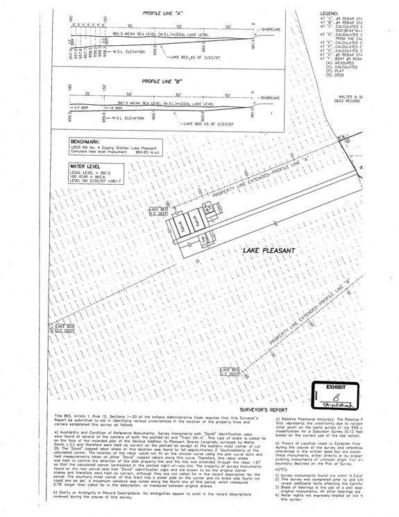
PL-20,551 of authorization to dredge beneath two boat lifts that were to be
placed along the extended temporary pier.
Clauss subsequently withdrew this element of his petition, and it is not
further considered here.
3.
The correspondence described in Finding 1 initiated a proceeding under IC
4-21.5 (sometimes referred to as the “Administrative Orders and Procedures Act”
or “AOPA”). The Commission adopted 312
IAC 3-1 to assist with its implementation of AOPA.
4.
[VOLUME 11, PAGE 151]
5.
The Commission has jurisdiction over the subject matter and over the persons of
the parties.
B. Hearing de Novo and
Burden of Proof
6. Administrative review of a DNR licensure determination
is conducted de novo. Rather than
deferring to the DNR determination, de novo review requires the administrative
law judge to consider and apply proper weight to the evidence presented in a
proceeding. Crafton, et al. v
7. At each stage of a proceeding, the party requesting
that an agency take action or asserting an affirmative defense has the burden
of going forward and the burden of persuasion (sometimes collectively referred
to as the burden of proof) with the evidence.
IC 4-21.5-3-14(c). A person seeking
the benefit of a license has the burden of proof for entitlement to the
license. DNR v. United Refuse Co.,
cited previously, and Ind. DNR and NRC v.
Krantz Bros. Const., 581 N.E.2d 935 (Ind. App. 1991).
8. The hearing in
this proceeding is conducted de novo. As
the license applicant, Clauss has the burden of proof.
C. Licensure of Temporary
Piers
9. Unless
a person obtains a DNR license under IC 14-26-2-23 of the Lakes Preservation
Act, the person cannot lawfully place a temporary structure over, along, or
lakeward of the “shoreline or water line” of a public freshwater lake. IC 14-26-2-23(a).
10.
The water level of
11.
The Indiana General Assembly directed the Commission to adopt rules to provide
objective standards for issuing licenses under IC 14-26-2-23, including
standards for the configuration of piers, boat stations, platforms and similar structures. The standards are to exempt any class of
activities from licensing, including temporary structures, if the Commission
finds that the class is unlikely to pose more than a minimal potential for harm
to the public rights described in IC 14-26-2-5.
IC 14-26-2-23(e).
12.
The “public rights” referenced in IC 14-26-2-5 are “natural resources and the
natural scenic beauty of
[VOLUME 11, PAGE 152]
13.
Applying these statutory authorities, and particularly IC 14-26-2-23(e), the
Commission has developed a regulatory design that authorizes the placement of temporary
piers, boat stations and similar structures under a partial exemption that is
commonly referred to as a “general license”.
Under this regulatory design, a qualified structure can be placed within
a public freshwater lake without obtaining a prior written license (or what is
sometimes called an “individual license”) from the DNR.
14.
As provided in pertinent part in 312 IAC 11-3-1(a) and (b):
(a) The
placement of a temporary structure…is authorized without a written license
issued by the [DNR under the Lakes Preservation Act and 312 IAC 11-3] if the
temporary structure qualifies under this section.
(b) In order for a temporary structure to
qualify, the structure must satisfy each of the following:
(1) Be easily removable.
(2) Not infringe on the access of an
adjacent landowner to the public freshwater lake.
(3) Not unduly restrict navigation.
(4) Not be unusually wide or long relative
to similar structures within the vicinity on the same public freshwater lake.
(5) Not extend more than one hundred fifty
(150) feet from the…shoreline [or water line].
(6) If a pier, not extend over water that
is continuously more than six (6) feet deep to a distance of one hundred fifty
(150) feet from the…shoreline [or water line].
(7) Not be a marina.
(8) Not be a group pier.
(9) Be placed by…a riparian owner.
D. Navigation Buoys and the
15.
A hearing was conducted as scheduled in this proceeding on April 12, 2007
during which the parties provided testimony and offered documents into
evidence.
16.
Testimony and documents were offered pertaining to the placement of a solid
orange buoy (the “orange buoy”) near the location of the proposed temporary
pier. The orange buoy is visible on
copies of three photographs in the riparian area of
17.
Conservation Officer Warner of the DNR’s Division of Law Enforcement testified
he was aware of the placement of the orange buoy, but the orange buoy has not
been licensed by the DNR. The orange
buoy has been placed the last two or three boating seasons.
[VOLUME 11, PAGE 153]
18.
Clauss testified the orange buoy has been placed in shallow water by the Lake
Pleasant Home Owners Association. Nancy
L. Bandelier, Secretary-Treasurer of the Lake Pleasant Home Owners Association,
provided an April 9, 2007 letter in which she stated the orange “buoy is
positioned approximately 350-400 ft. from the shoreline to discourage boaters
from entering the area and incurring damage to props, etc.”
19.
The licensure of navigation aids and water recreation structures is governed by
statute at IC 14-15-7-3 primarily through rules at 312 IAC 5-4. A “buoy” is a form of navigation aid. 312 IAC 5-2-23(1).
20.
As provided in pertinent part at 312 IAC 5-4-1:
(a) [312 IAC 5-4] governs the placement of
any navigation aid or water recreation structure.
(b) A person must comply with [312 IAC
5-4] before placing a navigation aid or water recreation structure on or along
a public water. Except as provided in
subsections (d) and (e), a license from the [DNR’s Division of Law Enforcement]
is required for the placement of a navigation aid or water recreation
structure.
(c) Except as provided in subsections (d)
and (e), each navigation aid must be colored white with international orange geometric
shapes. If placed on the water, a navigation aid must be a buoy.
(d) A buoy that identifies a point two
hundred (200) feet from the shoreline of any lake or channel under IC
14-15-3-17 is exempted from subsection (c). This exemption does not apply to
(e) This rule does not apply to a
navigation aid or water recreation structure located within one hundred fifty
(150) feet from the waterline or shoreline of a public freshwater lake or to a
mooring buoy….
21.
As a consequence of 312 IAC 5-4-1, a navigation aid placed in public waters
must comply with subsection (c) unless the buoy “identifies a point two hundred
(200) feet from the shoreline of a lake or channel under IC 14-15-3-17 or is
located within 150 feet of the shoreline or water line of a public freshwater
lake. The evidence is unrefuted that the
orange buoy is considerably more than 200 feet from the shoreline or water line
of
22.
In addition, the Lake Pleasant Homeowners Association describes a purpose for
the orange buoy which is inconsistent with 312 IAC 5-4-1(d). As stated in the subsection, and as confirmed
by testimony from First Sergeant William Snyder of the DNR’s Division of Law
Enforcement, the sole purpose for such a buoy is to assist in identifying a
point 200 feet from the shoreline of a lake.
The Indiana General Assembly has established an “idle speed” zone for
motorboats operated within 200 feet of the shoreline of a lake. IC 14-15-3-17.
[VOLUME 11, PAGE 154]
23. The orange buoy does not qualify for an
exemption from the requirements of 312 IAC 5-4-1(c).
24.
312 IAC 5-4-1(c) requires that “each navigation aid must be colored white with
international orange geometric shapes.”
The specifications for geometric shapes are set forth by description and
with illustrations at 312 IAC 5-4-6. A
vertical, open-faced diamond shape means danger. Other geometric shapes provide other
navigation requirements, information or directions.
25.
The orange buoy is required to be licensed by the DNR’s Division of Law
Enforcement but is unlicensed. The
orange buoy does not satisfy the licensure requirements of 312 IAC 5-4-1 and
could not lawfully be licensed at its current location. The sole function, for a buoy colored as is
the orange buoy, is to help identify a point 200 feet from the shoreline or
water line of
26.
Under proper circumstances, the establishment of a special watercraft zone by
statute or rule, or the placement of a buoy which is licensed and qualifies as
a navigation aid, could be considered in determining the propriety of the
placement of a temporary pier. Determining the placement of a temporary pier
cannot be founded, in whole or in part, on a buoy which is unlicensed and which
does not conform to legal requirements for coloring and geometric shapes. The orange buoy provides no basis for
consideration of the propriety of the temporary pier that is sought in
PL-20,551.[1]
E. Qualification to Place a
Temporary Pier under PL-20,551
27.
Clauss owns Lot 29 in the Plat of Pleasant Shores Second Addition,
28.
In order to place a temporary pier that does not meet the conditions for a
general license under 312 IAC 3-1, a person must apply for a written license
and must meet the burden of proving the person is entitled to a written
license. Clauss seeks to place a
temporary pier, with two boat lifts and a ski lift, which would extend 185 feet
from the shoreline or water line of
[VOLUME 11, PAGE 155]
29.
The structures sought to be placed by Clauss are depicted in a survey prepared
for him by James D. Burlage, a Registered Indiana Land Surveyor, and admitted
into evidence as Stipulated Exhibit B:
30.
The property immediately adjacent and north of Lot 29 is owned by Walter and
Sharon David (the “Davids”), and Clauss and the Davids have bordering riparian
zones within
31.
In the summer of 2004, Conservation Officer Donald Warner was requested to
respond to a complaint by the Davids that a pier placed by Clauss encroached
upon the Davids’ riparian zone. Warner
visited the site and offered his opinion that the line separating their
riparian zones was properly an extension of the terrestrial line separating
[VOLUME 11, PAGE 156]
32.
Clauss testified that following Warner’s visit, Clauss and Walter David reached
an informal agreement. Clauss was
allowed to leave his pier in place for 2004, but he promised to relocate the
pier in subsequent years so as not intersect the terrestrial property line with
the Davids extended lakeward. Clauss
testified since 2004, he and the Davids have not had a dispute regarding pier
placement.
33.
James D. Burlage identified the boundaries of Lot 29 and provided water depth
profiles along the lakeward extension of the terrestrial line separating
34.
On January 12, 2007, First Sergeant William Snyder and Conservation Officer
Donald Warner conducted measurements to provide water depth profiles, parallel
to and ten feet southeast of, the extension of the terrestrial line separating
35.
The measurements by Burlage are found to be dependable and accurate.
36.
The measurements by Snyder and Warner are accorded less credibility than those
of Burlage. Even so, the measurements by
Snyder and Warner have some probative value.
The practical identity of depths found by Burlage at 150 feet along the
extended terrestrial line separating Lot 29 and Davids’ property, compared with
depths found by Snyder and Warner ten feet southeast of that line, lend
credibility to the their measurements.
37.
The preponderance of the evidence supports a finding that the differences in
depth found by Burlage at 185 feet (50 inches), relative to depth found by Snyder
and Warner at 185 feet but ten feet southeasterly (39 inches), is in
significant part attributable to an overall increase in lake depth moving from
south to north. Sgt. Snyder testified
the water was deeper extending generally northerly and remaining 185 feet from
the shoreline, and he identified a “Florida-shaped” depression discernable on
Stipulated Exhibit D in support of his testimony. This general trend is also supported by
Stipulated Exhibit B where Burlage identifies a depth profile of only 2.3 feet
(approximately 28 inches) along the southerly boundary of
[VOLUME 11, PAGE 157]
38.
Snyder testified that a pier as proposed in Stipulated Exhibit B would pose an
unreasonable hazard to safety for persons boating on
39.
Snyder also testified the law enforcement professionals within the three
Districts of the DNR’s Division of Law Enforcement for
40.
Clauss testified that persons operating watercraft on
41.
In response, Snyder testified that because of the proximity of
42.
As provided in
Persons operating vessels on the waters of
[
[VOLUME 11, PAGE 158]
43.
In the absence of a statute in
44.
Clauss has not sustained his burden of proving that the pier and boat lifts
should be extended 185 feet from the shoreline or water line of
45.
The evidence does support a modification of the denial of PL-20,551 to
authorize Clauss to place a pier and boat lifts as depicted in Stipulated
Exhibit B, but with the added restriction that no portion of these structures
should extend more than 175 feet from the shoreline or water line of Lake
Pleasant (as contrasted to 185 feet from the shoreline as depicted in
Stipulated Exhibit B). No portion of the
pier, boat lift or moored boat should be located within ten feet of the line
identified in Stipulated Exhibit B as the property line extended—Profile Line
“A”, although a minimal extension of the canopy should not be prohibited
provided it would not interfere with navigation.[4]