NATURAL RESOURCES COMMISSION
Information Bulletin #56 (Third Amendment)
Subject: Riparian Zones within Public Freshwater Lakes and Navigable Waters
A state agency may issue statements in the conduct of its affairs that interpret, supplement, or implement a statute. Where these statements are not adopted as rules and are not intended to have the effect of law, they are required to be delivered to the Legislative Services Agency for publication in the Indiana Register as nonrule policy documents1.
The purpose of this nonrule policy document (described here as "this information bulletin") is to assist with interpreting, supplementing, and implementing the responsibilities of the Department with respect to:
The scope of this information bulletin is to provide guidance for determining the boundaries of riparian zones within public freshwater lakes and within navigable waters. The guidance helps define the relationships between neighboring riparian owners, between easement holders and the fee ownership, and between riparian owners and public use of the waters.
In developing the guidance, consideration has been given to the following:
(1) Reported decisions by the Indiana Supreme Court and the Indiana Court of Appeals.
(2) Decisions by the Commission posted in Caddnar. An agency is required to index final orders and may rely upon indexed orders as precedent. Caddnar is the Commission's index of agency decisions. If a party to an administrative adjudication cites a precedent from Caddnar, the Commission is required to cite or distinguish the precedent in a decision2.
(3) Expertise of the Department, the Commission, and the Advisory Council.
These definitions apply to this information bulletin:
"Advisory Council" refers to the advisory council established by
IC 14-9-6-1 to serve the bureau of water and resource regulation and the bureau of lands and cultural resources.
"Commission" refers to the natural resources commission established by
IC 14-10-1-1.
"Department" refers to the department of natural resources created by
IC 14-9-1-1.
"Navigable" means:
(a) A waterway that has been declared to be navigable or a public highway by one (1) or more of the following:
(1) A court.
(2) The Indiana General Assembly.
(3) The United States Army Corps of Engineers.
(4) The Federal Energy Regulatory Commission.
(6) The commission following a completed proceeding under
IC 4-21.5.
(b) To assist in the administration of this title, Information Bulletin #3 "Roster of Indiana Waterways Declared Navigable or Nonnavigable" published in the Indiana Register at
20211020-IR-312210433NRA3.
(c) The roster described in subsection (b) is not dispositive of whether a waterway is or is not navigable. In administrative review, the Commission would determine whether the waterway: "was available and susceptible for navigation according to the general rules of river transportation at the time [1816] Indiana was admitted to the Union. It does not depend on whether it is now navigable.... The true test seems to be the capacity of the stream, rather than the manner or extent of use. And the mere fact that the presence of sandbars or driftwood or stone, or other objects, which at times render the stream unfit for transportation, does not destroy its actual capacity and susceptibility for that use4". A modified standard for determining navigability would be applied to a waterway that did not exist in 1816.
"Ordinary high watermark" means the line as defined by
312 IAC 1-1-265 to establish the boundary of a navigable waterway.
"Public freshwater lake" has the meaning set forth in
312 IAC 11-2-176. To assist in identifying public freshwater lakes, Information Bulletin #61 "Listing of Public Freshwater Lakes" published in the Indiana Register at
20211020-IR-312210447NRA.
"Public waters" refers to a waterway that is either navigable or a public freshwater lake.
"Riparian owner" means the owner of land, or the owner of an interest in land sufficient to establish the same legal standing as the owner of land, bound by a waterway. The term includes a littoral owner.
"Riparian zone" means the portion of public waters where a riparian owner has particular rights that are correlative to those of citizens, under the public trust, and exclusive of those of neighboring riparian owners.
"Shore" means the shoreline or water line of a public freshwater lake or the ordinary high watermark of a navigable waterway.
"Shoreline" means "shoreline or water line" as defined by
IC 14-26-2-47 to establish the boundary of a public freshwater lake.
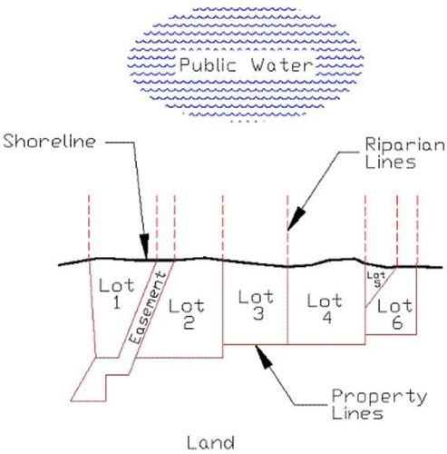
A riparian owner acquires rights to public waters from a fee title that extends at least to the shore9. Riparian rights may be transferred in a deed or other real estate conveyance without special mention, but the person who grants the deed may specifically reserve riparian rights. If the grantor reserves riparian rights, the grantee owns land adjacent to the public waters but is not the riparian owner10. A fee owner may also convey the ability to exercise riparian rights through an easement11. If an easement separates two fee owners, including an easement or right-of-way where a governmental entity is the beneficiary, riparian rights generally extend to the centerline of the easement or right-of-way12.
Where a waterway was navigable on the date of statehood, title passed to the state of Indiana and could not ordinarily be conveyed incident to a deed transfer made by a riparian owner13. Once a waterway is found to be navigable, it remains so, even if the waterway is no longer used for purposes of commercial navigation14.
For public waters, a public trust exists for which the state of Indiana is the trustee, and the Department is the state agency primarily responsible for administering the trust15. For navigable waters, the public trust was recognized in the Ordinance of 1787 and in Indiana common law16. The Lakes Preservation Act places full power and control of public freshwater lakes in the state of Indiana to hold in trust for the use of all citizens of Indiana to preserve natural scenic beauty and for recreational purposes. Riparian owners continue to possess rights with respect to a public freshwater lake, but their rights are statutory and must be balanced with the public's rights17.
A riparian owner along public waters typically enjoys rights that include: (1) access to the public water; (2) the placement of a pier to the line of navigability; (3) the use of accretions; and (4) reasonable use of the water for purposes such as boating and domestic use18. A person who is not a riparian owner, or who was not the recipient of rights conveyed to enjoy riparian ownership, is limited to the general rights of the public, such as for recreation or navigation. These rights of the general public do not include the placement of piers or the mooring of boats19.
The right to maintain a pier exists only so far out as not to interfere with the rights of the public or with the rights of other riparian owners. "These rights can co-exist only if the riparian right to build a pier is limited by the rights of the public and of other riparian owners20". To assist with safe navigation, as well as to preserve the public trust and the rights of neighboring riparian owners, there ideally should be 10 feet of clearance on both sides (for a total of 20 feet) of the dividing line between riparian zones. At a minimum, a total of 10 feet is typically required that is clear of piers and moored boats, although the area may be used for loading and unloading boats and for active recreation21.
A "reasonableness" test is applied to how far a pier may extend from the shore. The installation of a pier by a riparian owner is unreasonable if the pier interferes with the use of a public freshwater lake by others. "One point is well-settled...the boundaries of riparian property do not extend to the middle of the lake22". Neither do riparian boundaries extend to 200 feet from the shore of a public freshwater lake, a zone in which motorboats are limited to idle speed23. Any extension of a pier beyond the point required for the mooring and launching of boats may be considered unreasonable24.
The number of persons who can obtain riparian rights for land adjacent to public waters is infinite. The resources of public waters are finite, and riparian owners and the public must enjoy them in balance. The enjoyment of riparian rights must not overwhelm the public trust. This policy determination was underlined with recent statutory amendments to the Lakes Preservation Act that are now codified at
IC 14-26-2-2325. The Department may require common use of a structure if needed to accommodate the competing interests of riparian owners
26.
4. Principles for Delineating the Boundaries of Riparian Zones
Within this general framework, boundaries of riparian zones are delineated according to the following principles. These principles seek to accommodate the diverse characteristics of Indiana's numerous public freshwater lakes27. They are designed to provide riparian owners with equitable access to public waters28. Any diagram is intended to augment and provide examples of the principle that immediately precedes it or them.
First principle: Where properties are purchased subject to a homeowner association's constitution and bylaws, or a similar document intended to govern riparian rights, the document supersedes other principles governing a determination of riparian zones29.
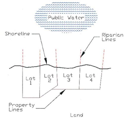
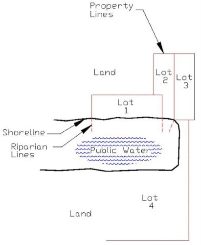
Second principle: Where the shore approximates a straight line, and where the onshore property boundaries are approximately perpendicular to this line, the boundaries of riparian zones are determined by extending the onshore boundaries into the public waters30.
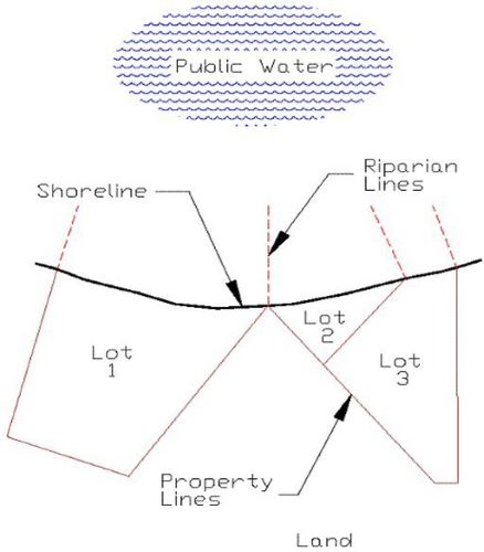
Third principle: Where the shore approximates a straight line, and where the onshore boundaries approach the shore at obtuse or acute angles, the boundaries of riparian zones are generally determined by extending a straight line at a perpendicular to the shore31. If the boundaries of two owners intersect at the shore, or in proximity to but landward of the shore, the boundaries of the riparian zones may be formed by a perpendicular to the shore from the point of intersection of the onshore boundaries. Application of the third principle is most compelling where land owners in the vicinity have historically used a perpendicular line to divide their riparian zones, but the principle should not be applied where a result is to deprive a riparian owner of reasonable access to public waters32.
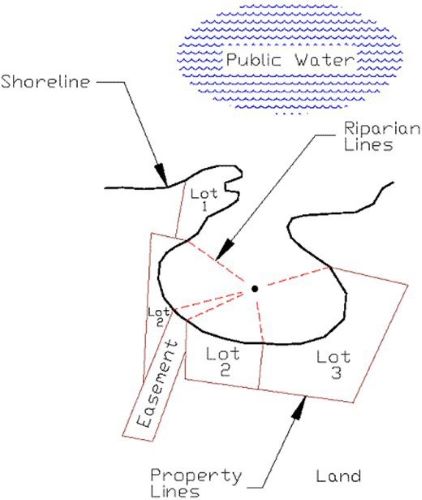
Fourth principle: Where the shore is irregular, and it is impossible to run lines at right angles to the shore for a just apportionment, the lines forming the boundaries between riparian zones should be run to divide the total navigable waterfront in proportion to the length of the shores of each owner taken according to the general trend of the shore33. If the navigable waterfront borders a lake that is substantially round or is a bay that is substantially round except for its connection to the main body of the public waters, the riparian zones may be formed by running lines from each owner's shore boundaries to the center of the lake or bay. If the navigable waterfront borders a long lake or other public waters that are not substantially round, the boundaries of the riparian zones may be formed by running a line through the center of the public waters, with deflected lines run from each owner's shore boundaries to intersect the centerline at perpendiculars.
If the boundaries of two owners intersect at the shore, or in proximity to but landward of the shore, the boundaries of the riparian zones may be formed by running a line from the owners' boundary intersection to the center of a substantially round public waters or to a center point where at the cul-de-sac of a long lake. Otherwise, for a long lake or other public waters, which are not substantially round, by running a line from the intersection of their boundaries to intersect the centerline at a perpendicular34.

This information bulletin was originally published in the Indiana Register on January 16, 2008 (
20080116-IR-312080013NRA). On November 18, 2008, the Commission approved the First Amendment (
20081210-IR-312080891NRA) adding incorporated opinions from the Court of Appeals of Indiana, which were issued later in 2008, as well as the adoption of
312 IAC 11-3-4. On March 16, 2010, the Commission approved the Second Amendment (
20100331-IR-312100175NRA) recognizing the Commission's "Listing of Public Freshwater Lakes", included new rules governing minimum clearances for group piers, corrected clerical errors, and made other technical changes. On September 21, 2021, the Commission approved this Third Amendment updating URL links and making other technical changes.
______________________________
3 In addition to publication on the website of the Legislative Services Agency, the Commission includes this nonrule policy document on its website. The Commission's website includes links at: https://www.in.gov/nrc/nonrule-policy-documents-npd/navigable-waterways-roster/ by county and waterway, to waters declared navigable or nonnavigable.
4 State v. Kivett, 228 Ind. 629, 95 N.E.2d 148 (Ind. 1950), subsequently referenced in this nonrule policy document as Kivett.
5 Sec. 26. "Ordinary high watermark" means the following:
(1) The line on the shore of a waterway established by the fluctuations of water and indicated by physical characteristics.
Examples of these physical characteristics include the following:
(A) A clear and natural line impressed on the bank.
(C) Changes in character of the soil.
(D) The destruction of terrestrial vegetation.
(E) The presence of litter or debris.
(2) Notwithstanding subdivision (1), the shore of Lake Michigan at five hundred eighty-one and five-tenths (581.5) feet I.G.L.D., 1985 (five hundred eighty-two and two hundred fifty-two thousandths (582.252) feet N.G.V.D., 1929).
6 Sec. 17. "Public freshwater lake" means a lake that has been used by the public with the acquiescence of a riparian owner. The term does not include any of the following:
(2) A lake lying wholly or in part within the city of East Chicago, Gary, or Hammond.
(3) A privately owned body of water used for the purpose of, or created as a result of, surface coal mining.
7 Sec. 4. As used in [
IC 14-26-2], "shoreline or water line" means:
(1) if the water level has been legally established, the line formed on the bank or shore by the water surface at the legally established average normal level; or
(2) if the water level has not been legally established, the line formed by the water surface at the average level as determined by:
(A) existing water level records; or
(B) if water level records are not available, the action of the water that has marked upon the soil of the bed of the lake a character distinct from that of the bank with respect to vegetation as well as the nature of the soil.
8 Sec. 29.5. "Waterway" means:
9 Brown v. Heidersbach, 172 Ind. App. 434, 440, 360 N.E.2d 614, 619 (Ind. 1977) cited in Bath v. Courts, 459 N.E.2d 72, 74 (Ind. App. 1984). These decisions are subsequently referenced in this nonrule policy document as "Brown" and "Bath", respectively.
10 Watson v. Thibodeau, 559 N.E.2d 1205, 1208 (Ind. App. 1990).
11 Several Indiana court decisions have considered whether a particular easement granted riparian rights to an easement holder. These include Brown; Klotz v. Horn, 558 N.E.2d 1096 (Ind. 1990); and, Parkison v. McCue, 831 N.E.2d 118 (Ind. App. 2005). The latter is subsequently referenced as "Parkison". A discussion of what factors are considered in determining whether an easement holder may properly exercise riparian rights is beyond the scope of this document.
12 Rufenbarger, et al. v. Blue, et al. 11 Caddnar 185 (2007), subsequently referred to as "Rufenbarger", at page 193.
13 Kivett. An exception to this general principle is established by
IC 14-18-6 providing Indiana land patents for qualified filled lands within Lake Michigan.
14 United States v. United States Steel Corporation, 482 F.2d 439 (7th Cir. 1973).
16 Lake Sand Co. v. State, 68 Ind. App. 439, 120 N.E. 715 (Ind. App. 1918). This decision and the Ordinance of 1787 are discussed in "The Public Trust Doctrine on Navigable Waters and Public Freshwater Lakes and The Lake Management Workgroups", Information Bulletin #41 (First Amendment), Natural Resources Commission,
20070214-IR-312070073NRA (March 1, 2007).
17 Lake of the Woods v. Ralston, 748 N.E.2d 396, 401 (Ind. App. 2001).
18 Parkison at page 128 and Center Township Corp. v. City of Mishawaka, 882 N.E.2d 762, 767 (Ind. App. 2008).
19 Havel & Stickelmeyer v. Fisher, et al., 11 Caddnar 110, 118 (2007) (subsequently "Havel") citing Barbee Villa Condominium Owners Assoc. v. Shrock, 10 Caddnar 23, 26 (2005).
21 Havel at page 119 and Rufenbarger at page 194. For "group piers" on public freshwater lakes, these minimum clearances are set forth in
312 IAC 11. See LSA Document 09-856(F) at
20101027-IR-312090856FRA. For "group piers" on navigable waters, they are set forth in
312 IAC 6-4-4.
22 Zapffe v. Srbeny, 587 N.E.2d 177 (Ind. App. 1992), subsequently referenced as Zapffe, at page 180.
24 Zapffe at page 181. On the facts, the Court of Appeals found that 50 feet from shore was a reasonable pier length. A Commission rule authorizes a general license for many temporary piers extending as far as 150 feet from shore, although the general license is contingent upon preserving navigation safety, compatibility with the activities of other riparian owners, and sufficient water depth to accomplish the purposes of the Lakes Preservation Act.
312 IAC 11-3-1. A detailed discussion of the rule section and related rule sections, pertaining to general licenses, is beyond the scope of this document.
25 P.L. 64-2000 and P.L. 152-2006.
28 Roberts v. Beachview Properties, LLC, et al., 10 Caddnar 125 (2005), subsequently referenced as "Roberts".
29 Lukis v. Ray, 888 N.E.2d 325 (Ind. App. 2008). This case is subsequently cited as Lukis.
31 Nosek v. Stryker, 103 Wis.2d 633, 309 N.W.2d 868 (Wis. 1981) (subsequently "Nosek"), a decision cited favorably by the Court of Appeals of Indiana in Lukis.
32 Pipp v. Spitler, et al., 11 Caddnar 39 (2007).
33 Nosek at page 872. This principle was applied in Lukis.
34 This principle was applied in Belcher and Belcher v. Yager-Rosales, 11 Caddnar 79 (2007).
Posted: 02/09/2022 by Legislative Services Agency
DIN: 20220209-IR-312220025NRA
Composed: Apr 18,2024 9:44:07PM EDT
A
PDF version of this document.