Summary
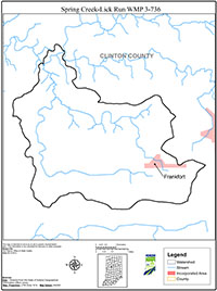
The Spring Creek-Lick Run Watershed is a 14-digit watershed located in North Central Indiana. It is one of 44 subwatersheds located in the Wildcat Creek Watershed. The Spring Creek-Lick Run Watershed drains 10,842 acres of predominantly agricultural land in Clinton County. Early settlers began clearing and farming the land in 1826. A 12 x 4 mile stretch of prime farmland known as the “Twelve Mile Prairie” is located in Clinton County and the southern portion of the Spring Creek-Lick Run Watershed. The Twelve Mile Prairie is considered some of the finest soil in the state for crop production.
There are approximately 16.8 miles of natural and constructed waterways in the Spring Creek-Lick Run Watershed that drain into the South Fork of Wildcat Creek. The streams are small, headwater streams. Forty-five percent of the streams are well buffered with trees, shrubs, and grasses beneficial for filtering sediments and pollutants. Areas that lack well-established streamside vegetation show signs of erosion and bank failure. The drainage ditches have very small, if any filter strips and could benefit from grass buffers to filter sediments and pollutants carried by stormwater.
According to the most recent data available from the Indiana Department of Environmental Management, there are two stretches of waterways in the Spring Creek-Lick Run Watershed that do not meet or are not expected to water quality standards. These are Heavilon Ditch and the South Fork of Wildcat Creek. Heavilon Ditch is listed for E coli, Ammonia, Organic Enrichment, and dissolved oxygen. The South Fork of Wildcat Creek is listed for cyanide and E. coli.
The Spring Creek-Lick Run Watershed Management Plan is the result of 18 months of meetings and discussion among federal, state, and local government staff, local industry, agriculture, developer, environmental, and concerned citizens. The emphasis of this Plan is improving water quality and addressing non-point sources of pollution from agricultural practices and urban development.
The discussion on agricultural practices focuses on both row crop and livestock operations. These include nutrients, pesticides, erosion and sedimentation, tillage practices, and conservation buffers for row crops and manure and pasture management for livestock operations.
The discussion on urban development looks at human and animal waste; household and yard waste; as well as development practices and encroachment of development in natural areas. The issue of failing septic systems in the Town of Jefferson has been well documented by both the local and state Board of Health as a source of water quality impairment. Wildlife and pet waste is also addressed as a water quality concern. The Plan discusses the importance of the proper use, storage, and disposal of everyday household hazardous waste and lawn and garden chemicals to minimize impacts on water quality. And finally, the Plan explores the relationship of land use planning and development practices to water quality.
The discussion on agricultural practices and urban development resulted in the development of five goals. Each goal represents a specific topic or issue as it relates to water quality concerns in the Spring Creek-Lick Run Watershed.