Land Records at the State Archives
The State Archives contains a wide variety of land records. As Indiana was a public domain state, virtually every acre was surveyed and then sold or otherwise granted by the federal government before settlement. The only exceptions are the lands around Vincennes settled by the French and George Rogers Clark's Grant around Clarksville.
A fuller description of the collection is available with formal notes, but, briefly, one can say that for all of Indiana, these land records exist:
- field notes - the surveyor's written description;
- plat maps - the surveyor's graphic description; and
- land office tract book entries - the accounts of individual purchases.
All of these are available for examination at the Archives.
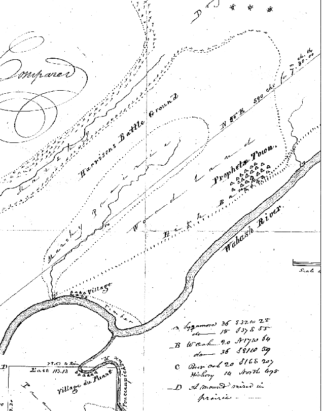
Tippecanoe Battle Ground Plat Map
After the Treaty of St. Mary's in 1818, the federal government had all the Indian reserves in northern Indiana surveyed and mapped. The plat map for one of the reserves included the site of General William Henry Harrison's battle with Tecumseh at Tippecanoe. This map is the earliest we can trace of the battlefield; it was probably surveyed in late 1819 or early 1820 by Deputy Surveyor Joseph S. Allen.
Land Office Databases
Of the six federal land offices in Indiana, the tract book records for Fort Wayne, LaPorte-Winamac, and Vincennes are available on the new Indiana Digital Archives. Patrons may now find the complete land description free online! These early land records enhance the Bureau of Land Management's Land Patent database by providing the date of purchase rather than the date the land patent was issued. This invaluable tool will often place early settlers on their land earlier than the patent date.
The records of a state land office, the Indianapolis Donation, are also available in a searchable database. This contains information on the original purchasers of the land given by the federal government to Indiana for the site of the new state capital.
To give an idea of what these databases can provide, the Archives' staff produced a subset of all entries, those labeled "Indian Reserves," from the LaPorte-Winamac database; this is, in a sense, a census of Indian lands in northwestern Indiana.
GLO Plat Maps Database
The Archaeological Resources Management Service, Department of Anthropology, Ball State University, working on a grant from the Indiana Department of Natural Resources, went over the plat maps produced by the surveyors of the US General Land Office and recorded all references to human habitations in a database. From this, the Archives' staff produced a list detailing the traces of Native American and pioneer settlement in General Land Office Database.
Note: Archives' records detail only initial surveys and sales from the public domain. All subsequent transactions and plat maps are held by the recorders in the individual counties of Indiana. Patrons interested in any transactions other than the first purchase from the public domain must contact the recorder of the county where the sale took place.
Hoosier Homestead Awards Database
The Hoosier Homestead Award recognizes farms that have been owned by the same family for one hundred years or more and stresses the contributions these family farms have made to the economic, cultural and social advancement of Indiana. The database provides information on the awards from 1976 to 1994.